1969
Tropical Cyclone (Gale) HORTENSE (1969044S15173)
IBTrACS version v04r00. Visit
IBTrACS website for data access.
Please direct all questions to the
IBTrACS Q and A forum
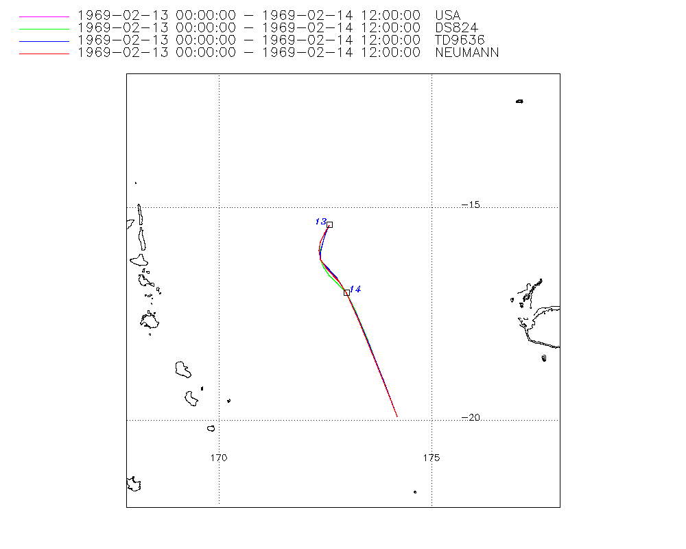
Storm track
-
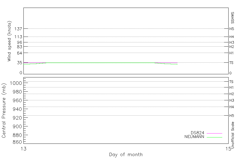
Intensity
-
Wind Radii
-
Intensity Data
-
Source Data
-
All data
Summary Information
|
|
| Storm ID |
1969044S15173 |
| Start |
Feb 13 00Z |
| Max Intensity |
35 kt (Feb 13 03Z) |
| End |
Feb 14 12Z |
| ATCF IDs |
SH211969 |
| Track status |
Best track data. |
|
Storm track plot
|
Intensity plots
|
Radial wind information
No radial wind information for this storm
|
Position and Intensity Table
| BASIN |
ISO_TIME_________ |
NATURE |
LAT |
LON |
DS824 WIND |
NEUMANN WIND |
| |
|
|
degrees north |
degrees east |
kts |
kts |
| SP |
1969-02-13 00:00:00 |
TS |
-15.40 |
172.60 |
35 |
30 |
| SP |
03:00:00 |
TS |
-15.61 |
172.49 |
35 |
32 |
| SP |
06:00:00 |
TS |
-15.81 |
172.41 |
35 |
35 |
| SP |
09:00:00 |
TS |
-16.01 |
172.37 |
35 |
35 |
| SP |
12:00:00 |
TS |
-16.20 |
172.40 |
35 |
35 |
| SP |
15:00:00 |
TS |
-16.38 |
172.48 |
35 |
35 |
| SP |
18:00:00 |
TS |
-16.56 |
172.62 |
35 |
35 |
| SP |
21:00:00 |
TS |
-16.72 |
172.79 |
35 |
35 |
| SP |
1969-02-14 00:00:00 |
TS |
-17.00 |
173.00 |
35 |
35 |
| SP |
03:00:00 |
TS |
-17.51 |
173.25 |
35 |
35 |
| SP |
06:00:00 |
TS |
-18.21 |
173.54 |
35 |
35 |
| SP |
09:00:00 |
TS |
-19.03 |
173.86 |
35 |
32 |
| SP |
12:00:00 |
TS |
-19.90 |
174.20 |
35 |
30 |
Source Information
| Agency |
Information |
| USA |
bsh211969.txt |
| TOKYO |
|
| CMA |
|
| HKO |
|
| NEWDELHI |
|
| REUNION |
|
| BOM |
|
| NADI |
|
| WELLINGTON |
|
| DS824 |
s_hem.dat:1090:21P |
| TD9636 |
cons_worldwide_trop_cyclone_18710101-19891231-006:Line=8150 |
| TD9635 |
|
| NEUMANN |
tracks.sh:Storm=240:HORTENSE:BSH2169:JTWC&NCDC |
| MLC |
|
All available IBTrACS Data
| SEASON |
BASIN |
SUBBASIN |
ISO_TIME_________ |
NATURE |
LAT |
LON |
DIST2LAND |
LANDFALL |
IFLAG |
USA AGENCY |
USA ATCF_ID |
USA LAT |
USA LON |
USA SSHS |
DS824 LAT |
DS824 LON |
DS824 STAGE |
DS824 WIND |
TD9636 LAT |
TD9636 LON |
TD9636 STAGE |
NEUMANN LAT |
NEUMANN LON |
NEUMANN CLASS |
NEUMANN WIND |
STORM SPEED |
STORM DIR |
| Year |
|
|
|
|
degrees north |
degrees east |
km |
km |
|
|
|
degrees north |
degrees east |
1 |
degrees north |
degrees east |
|
kts |
degrees north |
degrees east |
|
degrees north |
degrees east |
|
kts |
kts |
degrees |
| 1969 |
SP |
MM |
1969-02-13 00:00:00 |
TS |
-15.40 |
172.60 |
523 |
508 |
O________OO_O_ |
jtwc_sh |
SH211969 |
-15.40 |
172.60 |
-5 |
-15.40 |
172.60 |
TC |
35 |
-15.40 |
172.60 |
2 |
-15.40 |
172.60 |
TC |
30 |
5 |
207 |
| 1969 |
SP |
MM |
03:00:00 |
TS |
-15.61 |
172.49 |
508 |
494 |
P________PP_P_ |
|
SH211969 |
-15.60 |
172.49 |
-5 |
-15.60 |
172.49 |
TC |
35 |
-15.63 |
172.51 |
2 |
-15.60 |
172.49 |
TC |
32 |
5 |
204 |
| 1969 |
SP |
MM |
06:00:00 |
TS |
-15.81 |
172.41 |
494 |
492 |
O________OP_O_ |
jtwc_sh |
SH211969 |
-15.80 |
172.40 |
-5 |
-15.80 |
172.40 |
TC |
35 |
-15.85 |
172.43 |
2 |
-15.80 |
172.40 |
TC |
35 |
4 |
196 |
| 1969 |
SP |
MM |
09:00:00 |
TS |
-16.01 |
172.37 |
492 |
491 |
P________PP_P_ |
|
SH211969 |
-16.00 |
172.37 |
-5 |
-16.00 |
172.37 |
TC |
35 |
-16.05 |
172.39 |
2 |
-16.00 |
172.36 |
TC |
35 |
4 |
184 |
| 1969 |
SP |
MM |
12:00:00 |
TS |
-16.20 |
172.40 |
491 |
491 |
O________OO_O_ |
jtwc_sh |
SH211969 |
-16.20 |
172.40 |
-5 |
-16.20 |
172.40 |
TC |
35 |
-16.20 |
172.40 |
2 |
-16.20 |
172.40 |
TC |
35 |
4 |
164 |
| 1969 |
SP |
MM |
15:00:00 |
TS |
-16.38 |
172.48 |
501 |
501 |
P________PP_P_ |
|
SH211969 |
-16.40 |
172.47 |
-5 |
-16.40 |
172.47 |
TC |
35 |
-16.31 |
172.47 |
2 |
-16.40 |
172.53 |
TC |
35 |
4 |
149 |
| 1969 |
SP |
MM |
18:00:00 |
TS |
-16.56 |
172.62 |
511 |
489 |
O________OP_O_ |
jtwc_sh |
SH211969 |
-16.60 |
172.60 |
-5 |
-16.60 |
172.60 |
TC |
35 |
-16.44 |
172.60 |
2 |
-16.60 |
172.70 |
TC |
35 |
4 |
139 |
| 1969 |
SP |
MM |
21:00:00 |
TS |
-16.72 |
172.79 |
489 |
459 |
P________PP_P_ |
|
SH211969 |
-16.75 |
172.78 |
-5 |
-16.75 |
172.78 |
TC |
35 |
-16.65 |
172.78 |
2 |
-16.72 |
172.83 |
TC |
35 |
6 |
141 |
| 1969 |
SP |
MM |
1969-02-14 00:00:00 |
TS |
-17.00 |
173.00 |
459 |
427 |
O________OO_O_ |
jtwc_sh |
SH211969 |
-17.00 |
173.00 |
-5 |
-17.00 |
173.00 |
TC |
35 |
-17.00 |
173.00 |
2 |
-17.00 |
173.00 |
TC |
35 |
9 |
151 |
| 1969 |
SP |
MM |
03:00:00 |
TS |
-17.51 |
173.25 |
427 |
391 |
P________PP_P_ |
|
SH211969 |
-17.44 |
173.23 |
-5 |
-17.44 |
173.23 |
TC |
35 |
-17.54 |
173.26 |
2 |
-17.62 |
173.28 |
TC |
35 |
13 |
157 |
| 1969 |
SP |
MM |
06:00:00 |
TS |
-18.21 |
173.54 |
391 |
367 |
O________OP_O_ |
jtwc_sh |
SH211969 |
-18.10 |
173.50 |
-5 |
-18.10 |
173.50 |
TC |
35 |
-18.24 |
173.56 |
2 |
-18.40 |
173.60 |
TC |
35 |
16 |
159 |
| 1969 |
SP |
MM |
09:00:00 |
TS |
-19.03 |
173.86 |
365 |
365 |
P________PP_P_ |
|
SH211969 |
-18.95 |
173.83 |
-5 |
-18.95 |
173.83 |
TC |
35 |
-19.04 |
173.87 |
2 |
-19.16 |
173.91 |
TC |
32 |
18 |
160 |
| 1969 |
SP |
MM |
12:00:00 |
TS |
-19.90 |
174.20 |
380 |
|
O________OO_O_ |
jtwc_sh |
SH211969 |
-19.90 |
174.20 |
-5 |
-19.90 |
174.20 |
TC |
35 |
-19.90 |
174.20 |
2 |
-19.90 |
174.20 |
TC |
30 |
19 |
160 |