Current IBTrACS Version: v04r00
Introduction
This web page is an unofficial web portal for IBTrACS data. The goal is for this site to be a web browseable representation of IBTrACS data for demonstration purposes. Any official use of IBTrACS data should not be based on data from this site, but from the IBTrACS archive.
IBTrACS contains global tropical cyclone best-track data, collected from agencies in every ocean basin. The project has been endorsed by the World Meteorological Organization as the offical archiving and distribution resource for best-track data. The data were collected and processed by the IBTrACS group at the NOAA National Centers for Environmental Information (NCEI) in Asheville, NC.
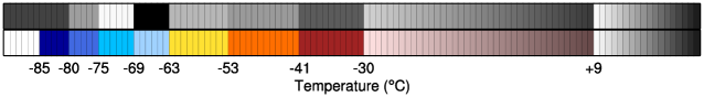
The IBTrACS Browse pages also provide access to satellite imagery based on infrared window brightness temperatures. The color scale is based on the Dvorak Technique intervals, but modified to include color. The colorbar below provides a mapping of the color imagery to temperature.
The menu at left provides access to IBTrACS data. Data are updated in real-time several times per week. Contact the IBTrACS group at NCEI if you have questions about the data on these pages.