1925
Tropical Depression NOT_NAMED (1925009S19067)
IBTrACS version v04r00. Visit
IBTrACS website for data access.
Please direct all questions to the
IBTrACS Q and A forum
Storm track
-
Intensity
-
Wind Radii
-
Intensity Data
-
Source Data
-
All data
Summary Information
|
|
| Storm ID |
1925009S19067 |
| Start |
Jan 9 00Z |
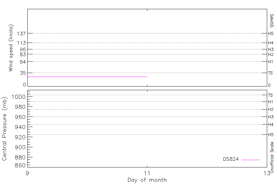
| Max Intensity |
25 kt (Jan 9 03Z) |
| End |
Jan 11 00Z |
| ATCF IDs |
|
| Track status |
Best track data. |
|
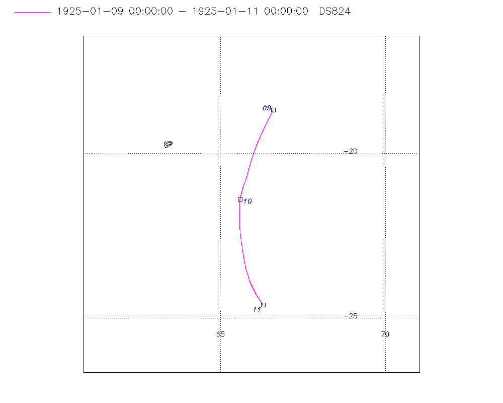
Storm track plot
|
Intensity plots
|
Radial wind information
No radial wind information for this storm
|
Position and Intensity Table
| BASIN |
ISO_TIME_________ |
NATURE |
LAT |
LON |
DS824 WIND |
| |
|
|
degrees north |
degrees east |
kts |
| SI |
1925-01-09 00:00:00 |
TS |
-18.70 |
66.60 |
25 |
| SI |
03:00:00 |
TS |
-18.99 |
66.45 |
25 |
| SI |
06:00:00 |
TS |
-19.30 |
66.30 |
25 |
| SI |
09:00:00 |
TS |
-19.64 |
66.14 |
25 |
| SI |
12:00:00 |
TS |
-20.00 |
66.00 |
25 |
| SI |
15:00:00 |
TS |
-20.35 |
65.89 |
25 |
| SI |
18:00:00 |
TS |
-20.70 |
65.80 |
25 |
| SI |
21:00:00 |
TS |
-21.04 |
65.69 |
25 |
| SI |
1925-01-10 00:00:00 |
TS |
-21.40 |
65.60 |
25 |
| SI |
03:00:00 |
TS |
-21.84 |
65.58 |
25 |
| SI |
06:00:00 |
TS |
-22.30 |
65.60 |
25 |
| SI |
09:00:00 |
TS |
-22.71 |
65.64 |
25 |
| SI |
12:00:00 |
TS |
-23.10 |
65.70 |
25 |
| SI |
15:00:00 |
TS |
-23.51 |
65.78 |
25 |
| SI |
18:00:00 |
TS |
-23.90 |
65.90 |
25 |
| SI |
21:00:00 |
TS |
-24.26 |
66.08 |
25 |
| SI |
1925-01-11 00:00:00 |
TS |
-24.60 |
66.30 |
25 |
Source Information
| Agency |
Information |
| USA |
|
| TOKYO |
|
| CMA |
|
| HKO |
|
| NEWDELHI |
|
| REUNION |
|
| BOM |
|
| NADI |
|
| WELLINGTON |
|
| DS824 |
s_hem.dat:246:NOT NAMED |
| TD9636 |
|
| TD9635 |
|
| NEUMANN |
|
| MLC |
|
All available IBTrACS Data
| SEASON |
BASIN |
SUBBASIN |
ISO_TIME_________ |
NATURE |
LAT |
LON |
DIST2LAND |
LANDFALL |
IFLAG |
USA SSHS |
DS824 LAT |
DS824 LON |
DS824 STAGE |
DS824 WIND |
STORM SPEED |
STORM DIR |
| Year |
|
|
|
|
degrees north |
degrees east |
km |
km |
|
1 |
degrees north |
degrees east |
|
kts |
kts |
degrees |
| 1925 |
SI |
MM |
1925-01-09 00:00:00 |
TS |
-18.70 |
66.60 |
939 |
922 |
_________O____ |
-5 |
-18.70 |
66.60 |
TC |
25 |
6 |
206 |
| 1925 |
SI |
MM |
03:00:00 |
TS |
-18.99 |
66.45 |
922 |
896 |
_________P____ |
-5 |
-18.99 |
66.45 |
TC |
25 |
7 |
205 |
| 1925 |
SI |
MM |
06:00:00 |
TS |
-19.30 |
66.30 |
896 |
881 |
_________O____ |
-5 |
-19.30 |
66.30 |
TC |
25 |
7 |
204 |
| 1925 |
SI |
MM |
09:00:00 |
TS |
-19.64 |
66.14 |
870 |
856 |
_________P____ |
-5 |
-19.64 |
66.14 |
TC |
25 |
8 |
202 |
| 1925 |
SI |
MM |
12:00:00 |
TS |
-20.00 |
66.00 |
856 |
844 |
_________O____ |
-5 |
-20.00 |
66.00 |
TC |
25 |
7 |
198 |
| 1925 |
SI |
MM |
15:00:00 |
TS |
-20.35 |
65.89 |
844 |
833 |
_________P____ |
-5 |
-20.35 |
65.89 |
TC |
25 |
7 |
195 |
| 1925 |
SI |
MM |
18:00:00 |
TS |
-20.70 |
65.80 |
834 |
824 |
_________O____ |
-5 |
-20.70 |
65.80 |
TC |
25 |
7 |
196 |
| 1925 |
SI |
MM |
21:00:00 |
TS |
-21.04 |
65.69 |
825 |
817 |
_________P____ |
-5 |
-21.04 |
65.69 |
TC |
25 |
7 |
195 |
| 1925 |
SI |
MM |
1925-01-10 00:00:00 |
TS |
-21.40 |
65.60 |
819 |
819 |
_________O____ |
-5 |
-21.40 |
65.60 |
TC |
25 |
8 |
187 |
| 1925 |
SI |
MM |
03:00:00 |
TS |
-21.84 |
65.58 |
826 |
826 |
_________P____ |
-5 |
-21.84 |
65.58 |
TC |
25 |
9 |
0 |
| 1925 |
SI |
MM |
06:00:00 |
TS |
-22.30 |
65.60 |
838 |
838 |
_________O____ |
-5 |
-22.30 |
65.60 |
TC |
25 |
9 |
176 |
| 1925 |
SI |
MM |
09:00:00 |
TS |
-22.71 |
65.64 |
850 |
850 |
_________P____ |
-5 |
-22.71 |
65.64 |
TC |
25 |
8 |
174 |
| 1925 |
SI |
MM |
12:00:00 |
TS |
-23.10 |
65.70 |
873 |
873 |
_________O____ |
-5 |
-23.10 |
65.70 |
TC |
25 |
8 |
171 |
| 1925 |
SI |
MM |
15:00:00 |
TS |
-23.51 |
65.78 |
899 |
899 |
_________P____ |
-5 |
-23.51 |
65.78 |
TC |
25 |
8 |
167 |
| 1925 |
SI |
MM |
18:00:00 |
TS |
-23.90 |
65.90 |
925 |
925 |
_________O____ |
-5 |
-23.90 |
65.90 |
TC |
25 |
8 |
160 |
| 1925 |
SI |
MM |
21:00:00 |
TS |
-24.26 |
66.08 |
961 |
961 |
_________P____ |
-5 |
-24.26 |
66.08 |
TC |
25 |
8 |
152 |
| 1925 |
SI |
MM |
1925-01-11 00:00:00 |
TS |
-24.60 |
66.30 |
994 |
|
_________O____ |
-5 |
-24.60 |
66.30 |
TC |
25 |
8 |
150 |