1992
Tropical Storm JANIS (1992216N10145)
IBTrACS version v04r00. Visit
IBTrACS website for data access.
Please direct all questions to the
IBTrACS Q and A forum
Storm track
-
Intensity
-
Wind Radii
-
Intensity Data
-
Source Data
-
All data
Summary Information
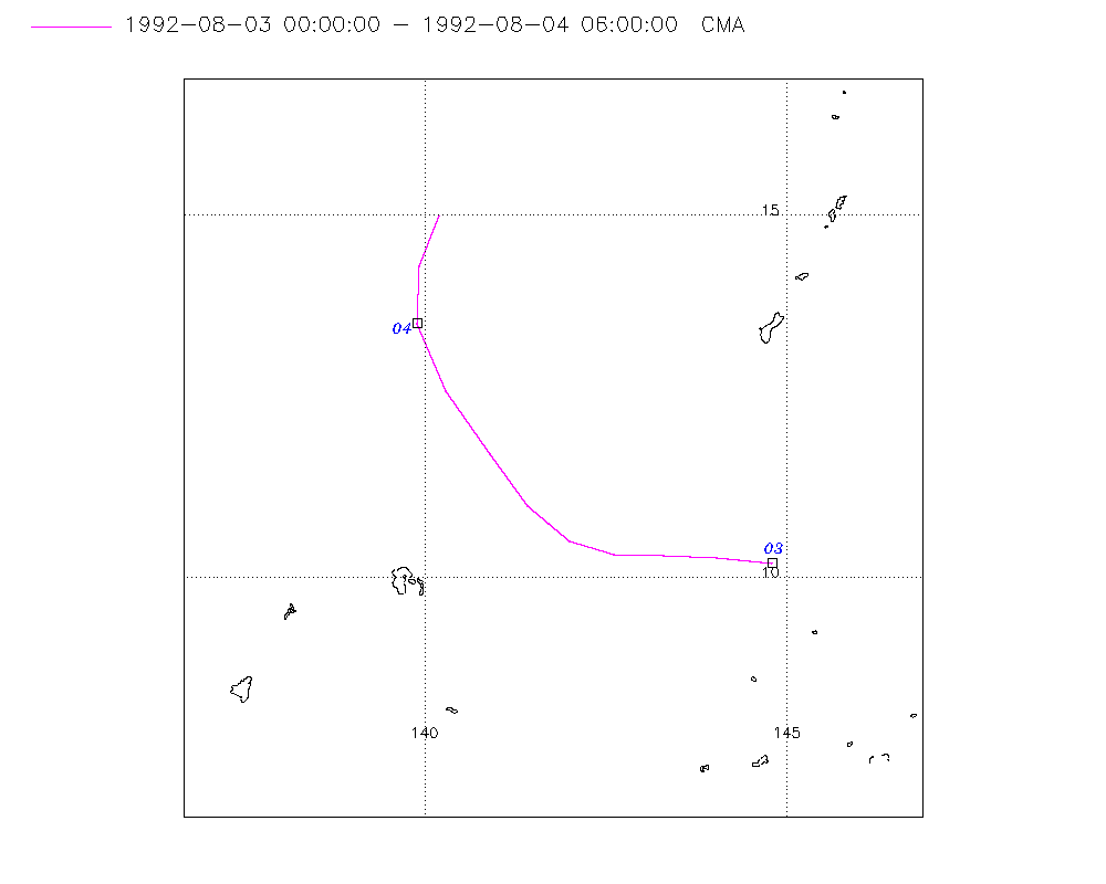
Storm track plot
|
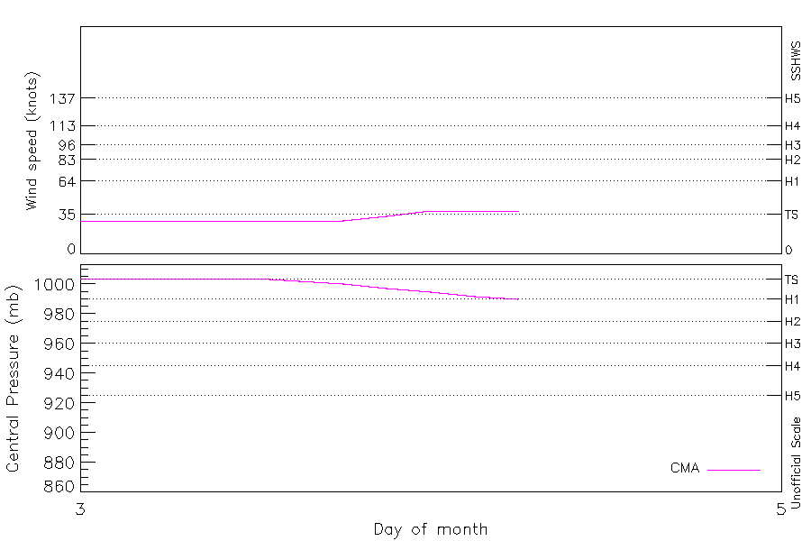
Intensity plots
|
Radial wind information
No radial wind information for this storm
|
Position and Intensity Table
Source Information
| Agency |
Information |
| USA |
|
| TOKYO |
|
| CMA |
CH1992BST.txt:Storm=11:Janis |
| HKO |
|
| NEWDELHI |
|
| REUNION |
|
| BOM |
|
| NADI |
|
| WELLINGTON |
|
| DS824 |
|
| TD9636 |
|
| TD9635 |
|
| NEUMANN |
|
| MLC |
|
All available IBTrACS Data
| SEASON |
BASIN |
SUBBASIN |
ISO_TIME_________ |
NATURE |
LAT |
LON |
DIST2LAND |
LANDFALL |
IFLAG |
USA SSHS |
CMA LAT |
CMA LON |
CMA CAT |
CMA WIND |
CMA PRES |
STORM SPEED |
STORM DIR |
| Year |
|
|
|
|
degrees north |
degrees east |
km |
km |
|
1 |
degrees north |
degrees east |
1 |
kts |
mb |
kts |
degrees |
| 1992 |
WP |
MM |
1992-08-03 00:00:00 |
TS |
10.20 |
144.80 |
1392 |
1392 |
__O___________ |
-5 |
10.20 |
144.80 |
1 |
29 |
1004 |
14 |
274 |
| 1992 |
WP |
MM |
03:00:00 |
TS |
10.25 |
144.09 |
1416 |
1416 |
__P___________ |
-5 |
10.27 |
144.04 |
1 |
29 |
1004 |
15 |
274 |
| 1992 |
WP |
MM |
06:00:00 |
TS |
10.30 |
143.30 |
1436 |
1423 |
__O___________ |
-5 |
10.30 |
143.30 |
1 |
29 |
1004 |
15 |
273 |
| 1992 |
WP |
MM |
09:00:00 |
TS |
10.32 |
142.62 |
1419 |
1412 |
__P___________ |
-5 |
10.32 |
142.62 |
1 |
29 |
1004 |
13 |
279 |
| 1992 |
WP |
MM |
12:00:00 |
TS |
10.50 |
142.00 |
1419 |
1416 |
__O___________ |
-5 |
10.50 |
142.00 |
1 |
29 |
1004 |
14 |
299 |
| 1992 |
WP |
MM |
15:00:00 |
TS |
10.98 |
141.43 |
1455 |
1455 |
__P___________ |
-5 |
10.98 |
141.43 |
1 |
29 |
1002 |
16 |
318 |
| 1992 |
WP |
MM |
18:00:00 |
TS |
11.70 |
140.90 |
1505 |
1505 |
__O___________ |
-5 |
11.70 |
140.90 |
1 |
29 |
1000 |
20 |
325 |
| 1992 |
WP |
MM |
21:00:00 |
TS |
12.58 |
140.30 |
1577 |
1554 |
__P___________ |
-5 |
12.58 |
140.30 |
1 |
33 |
997 |
21 |
332 |
| 1992 |
WP |
MM |
1992-08-04 00:00:00 |
TS |
13.50 |
139.90 |
1558 |
1558 |
__O___________ |
-5 |
13.50 |
139.90 |
2 |
38 |
995 |
17 |
350 |
| 1992 |
WP |
MM |
03:00:00 |
TS |
14.27 |
140.00 |
1584 |
1584 |
__P___________ |
-5 |
14.29 |
139.92 |
2 |
38 |
992 |
15 |
11 |
| 1992 |
WP |
MM |
06:00:00 |
TS |
15.00 |
140.20 |
1619 |
|
__O___________ |
-5 |
15.00 |
140.20 |
2 |
38 |
990 |
15 |
15 |