1976
Tropical Depression NOT_NAMED (1976039N06132)
IBTrACS version v04r00. Visit
IBTrACS website for data access.
Please direct all questions to the
IBTrACS Q and A forum
Storm track
-
Intensity
-
Wind Radii
-
Intensity Data
-
Source Data
-
All data
Summary Information
|
|
| Storm ID |
1976039N06132 |
| Start |
Feb 8 00Z |
| Max Intensity |
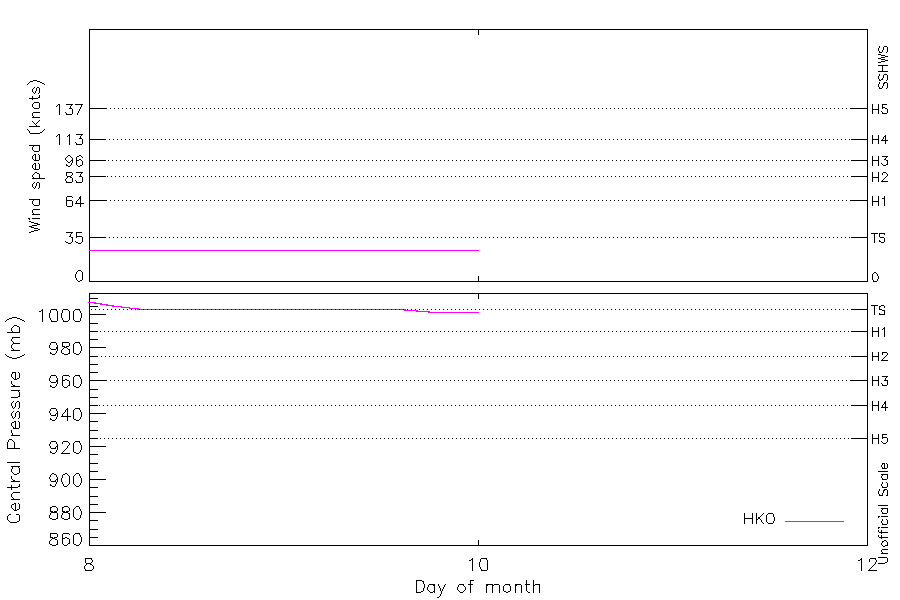
25 kt (Feb 8 03Z) |
| End |
Feb 10 00Z |
| ATCF IDs |
|
| Track status |
Best track data. |
|
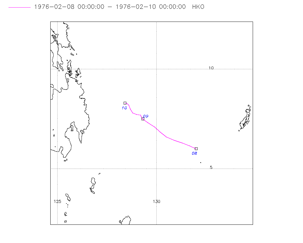
Storm track plot
|
Intensity plots
|
Radial wind information
No radial wind information for this storm
|
Position and Intensity Table
| BASIN |
ISO_TIME_________ |
NATURE |
LAT |
LON |
HKO WIND |
HKO PRES |
| |
|
|
degrees north |
degrees east |
kts |
mb |
| WP |
1976-02-08 00:00:00 |
NR |
6.00 |
132.00 |
25 |
1008 |
| WP |
03:00:00 |
NR |
6.16 |
131.67 |
25 |
1006 |
| WP |
06:00:00 |
NR |
6.30 |
131.30 |
25 |
1004 |
| WP |
09:00:00 |
NR |
6.44 |
130.89 |
25 |
1004 |
| WP |
12:00:00 |
NR |
6.60 |
130.50 |
25 |
1004 |
| WP |
15:00:00 |
NR |
6.84 |
130.18 |
25 |
1004 |
| WP |
18:00:00 |
NR |
7.10 |
129.90 |
25 |
1004 |
| WP |
21:00:00 |
NR |
7.32 |
129.56 |
25 |
1004 |
| WP |
1976-02-09 00:00:00 |
NR |
7.50 |
129.30 |
25 |
1004 |
| WP |
03:00:00 |
NR |
7.62 |
129.23 |
25 |
1004 |
| WP |
06:00:00 |
NR |
7.70 |
129.20 |
25 |
1004 |
| WP |
09:00:00 |
NR |
7.74 |
129.01 |
25 |
1004 |
| WP |
12:00:00 |
NR |
7.80 |
128.80 |
25 |
1004 |
| WP |
15:00:00 |
NR |
8.00 |
128.69 |
25 |
1003 |
| WP |
18:00:00 |
NR |
8.20 |
128.60 |
25 |
1002 |
| WP |
21:00:00 |
NR |
8.29 |
128.50 |
25 |
1002 |
| WP |
1976-02-10 00:00:00 |
NR |
8.30 |
128.40 |
25 |
1002 |
Source Information
| Agency |
Information |
| USA |
|
| TOKYO |
|
| CMA |
|
| HKO |
tc-besttrack-data-current.txt:Line=10670:TD0208 |
| NEWDELHI |
|
| REUNION |
|
| BOM |
|
| NADI |
|
| WELLINGTON |
|
| DS824 |
|
| TD9636 |
|
| TD9635 |
|
| NEUMANN |
|
| MLC |
|
All available IBTrACS Data
| SEASON |
BASIN |
SUBBASIN |
ISO_TIME_________ |
NATURE |
LAT |
LON |
DIST2LAND |
LANDFALL |
IFLAG |
USA SSHS |
HKO LAT |
HKO LON |
HKO CAT |
HKO WIND |
HKO PRES |
STORM SPEED |
STORM DIR |
| Year |
|
|
|
|
degrees north |
degrees east |
km |
km |
|
1 |
degrees north |
degrees east |
|
kts |
mb |
kts |
degrees |
| 1976 |
WP |
MM |
1976-02-08 00:00:00 |
NR |
6.00 |
132.00 |
536 |
523 |
___O__________ |
-5 |
6.00 |
132.00 |
TD |
25 |
1008 |
7 |
295 |
| 1976 |
WP |
MM |
03:00:00 |
NR |
6.16 |
131.67 |
531 |
511 |
___P__________ |
-5 |
6.16 |
131.67 |
TD |
25 |
1006 |
8 |
293 |
| 1976 |
WP |
MM |
06:00:00 |
NR |
6.30 |
131.30 |
514 |
485 |
___O__________ |
-5 |
6.30 |
131.30 |
TD |
25 |
1004 |
8 |
290 |
| 1976 |
WP |
MM |
09:00:00 |
NR |
6.44 |
130.89 |
485 |
437 |
___P__________ |
-5 |
6.44 |
130.89 |
TD |
25 |
1004 |
9 |
291 |
| 1976 |
WP |
MM |
12:00:00 |
NR |
6.60 |
130.50 |
437 |
401 |
___O__________ |
-5 |
6.60 |
130.50 |
TD |
25 |
1004 |
8 |
300 |
| 1976 |
WP |
MM |
15:00:00 |
NR |
6.84 |
130.18 |
401 |
365 |
___P__________ |
-5 |
6.84 |
130.18 |
TD |
25 |
1004 |
8 |
310 |
| 1976 |
WP |
MM |
18:00:00 |
NR |
7.10 |
129.90 |
365 |
331 |
___O__________ |
-5 |
7.10 |
129.90 |
TD |
25 |
1004 |
8 |
308 |
| 1976 |
WP |
MM |
21:00:00 |
NR |
7.32 |
129.56 |
331 |
297 |
___P__________ |
-5 |
7.32 |
129.56 |
TD |
25 |
1004 |
7 |
304 |
| 1976 |
WP |
MM |
1976-02-09 00:00:00 |
NR |
7.50 |
129.30 |
297 |
286 |
___O__________ |
-5 |
7.50 |
129.30 |
TD |
25 |
1004 |
4 |
313 |
| 1976 |
WP |
MM |
03:00:00 |
NR |
7.62 |
129.23 |
286 |
286 |
___P__________ |
-5 |
7.62 |
129.23 |
TD |
25 |
1004 |
2 |
333 |
| 1976 |
WP |
MM |
06:00:00 |
NR |
7.70 |
129.20 |
286 |
264 |
___O__________ |
-5 |
7.70 |
129.20 |
TD |
25 |
1004 |
3 |
297 |
| 1976 |
WP |
MM |
09:00:00 |
NR |
7.74 |
129.01 |
264 |
242 |
___P__________ |
-5 |
7.74 |
129.01 |
TD |
25 |
1004 |
4 |
284 |
| 1976 |
WP |
MM |
12:00:00 |
NR |
7.80 |
128.80 |
242 |
232 |
___O__________ |
-5 |
7.80 |
128.80 |
TD |
25 |
1004 |
4 |
310 |
| 1976 |
WP |
MM |
15:00:00 |
NR |
8.00 |
128.69 |
233 |
224 |
___P__________ |
-5 |
8.00 |
128.69 |
TD |
25 |
1003 |
4 |
334 |
| 1976 |
WP |
MM |
18:00:00 |
NR |
8.20 |
128.60 |
227 |
219 |
___O__________ |
-5 |
8.20 |
128.60 |
TD |
25 |
1002 |
3 |
328 |
| 1976 |
WP |
MM |
21:00:00 |
NR |
8.29 |
128.50 |
219 |
209 |
___P__________ |
-5 |
8.29 |
128.50 |
TD |
25 |
1002 |
2 |
297 |
| 1976 |
WP |
MM |
1976-02-10 00:00:00 |
NR |
8.30 |
128.40 |
209 |
|
___O__________ |
-5 |
8.30 |
128.40 |
TD |
25 |
1002 |
2 |
277 |