1975
Tropical Cyclone (Gale) NOT_NAMED (1975020S24161)
IBTrACS version v04r00. Visit
IBTrACS website for data access.
Please direct all questions to the
IBTrACS Q and A forum
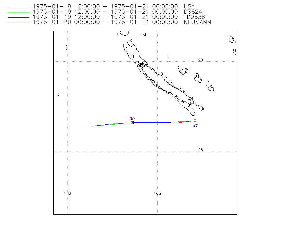
Storm track
-
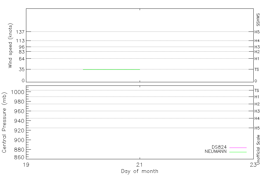
Intensity
-
Wind Radii
-
Intensity Data
-
Source Data
-
All data
Summary Information
|
|
| Storm ID |
1975020S24161 |
| Start |
Jan 19 12Z |
| Max Intensity |
35 kt (Jan 20 00Z) |
| End |
Jan 21 00Z |
| ATCF IDs |
SH151975 |
| Track status |
Best track data. |
|
Storm track plot
|
Intensity plots
|
Radial wind information
No radial wind information for this storm
|
Position and Intensity Table
| BASIN |
ISO_TIME_________ |
NATURE |
LAT |
LON |
DS824 WIND |
NEUMANN WIND |
| |
|
|
degrees north |
degrees east |
kts |
kts |
| SP |
1975-01-19 12:00:00 |
TS |
-23.60 |
161.40 |
|
|
| SP |
15:00:00 |
TS |
-23.55 |
162.00 |
|
|
| SP |
18:00:00 |
TS |
-23.49 |
162.58 |
|
|
| SP |
21:00:00 |
TS |
-23.44 |
163.12 |
|
|
| SP |
23:00:00 |
TS |
-23.41 |
163.45 |
|
|
| SP |
1975-01-20 00:00:00 |
TS |
-23.40 |
163.60 |
35 |
35 |
| SP |
03:00:00 |
TS |
-23.39 |
164.02 |
35 |
35 |
| SP |
06:00:00 |
TS |
-23.40 |
164.42 |
35 |
35 |
| SP |
09:00:00 |
TS |
-23.40 |
164.85 |
35 |
35 |
| SP |
12:00:00 |
TS |
-23.40 |
165.30 |
35 |
35 |
| SP |
15:00:00 |
TS |
-23.40 |
165.75 |
35 |
35 |
| SP |
18:00:00 |
TS |
-23.39 |
166.19 |
35 |
35 |
| SP |
21:00:00 |
TS |
-23.35 |
166.65 |
35 |
35 |
| SP |
1975-01-21 00:00:00 |
TS |
-23.30 |
167.10 |
35 |
35 |
Source Information
| Agency |
Information |
| USA |
bsh151975.txt |
| TOKYO |
|
| CMA |
|
| HKO |
|
| NEWDELHI |
|
| REUNION |
|
| BOM |
|
| NADI |
|
| WELLINGTON |
|
| DS824 |
s_hem.dat:1277:15P |
| TD9636 |
cons_worldwide_trop_cyclone_18710101-19891231-006:Line=9807 |
| TD9635 |
|
| NEUMANN |
tracks.sh:Storm=426:HSK1675:BSH1875:JTWC |
| MLC |
|
All available IBTrACS Data
| SEASON |
BASIN |
SUBBASIN |
ISO_TIME_________ |
NATURE |
LAT |
LON |
DIST2LAND |
LANDFALL |
IFLAG |
USA AGENCY |
USA ATCF_ID |
USA LAT |
USA LON |
USA SSHS |
DS824 LAT |
DS824 LON |
DS824 STAGE |
DS824 WIND |
TD9636 LAT |
TD9636 LON |
TD9636 STAGE |
NEUMANN LAT |
NEUMANN LON |
NEUMANN CLASS |
NEUMANN WIND |
STORM SPEED |
STORM DIR |
| Year |
|
|
|
|
degrees north |
degrees east |
km |
km |
|
|
|
degrees north |
degrees east |
1 |
degrees north |
degrees east |
|
kts |
degrees north |
degrees east |
|
degrees north |
degrees east |
|
kts |
kts |
degrees |
| 1975 |
SP |
MM |
1975-01-19 12:00:00 |
TS |
-23.60 |
161.40 |
435 |
386 |
O________OO___ |
jtwc_sh |
SH151975 |
-23.60 |
161.40 |
-5 |
-23.60 |
161.40 |
TC |
|
-23.60 |
161.40 |
2 |
|
|
|
|
11 |
85 |
| 1975 |
SP |
MM |
15:00:00 |
TS |
-23.55 |
162.00 |
379 |
333 |
P________PP___ |
|
SH151975 |
-23.55 |
162.02 |
-5 |
-23.55 |
162.02 |
TC |
|
-23.54 |
161.98 |
2 |
|
|
|
|
11 |
84 |
| 1975 |
SP |
MM |
18:00:00 |
TS |
-23.49 |
162.58 |
333 |
290 |
O________OP___ |
jtwc_sh |
SH151975 |
-23.50 |
162.60 |
-5 |
-23.50 |
162.60 |
TC |
|
-23.48 |
162.55 |
2 |
|
|
|
|
10 |
84 |
| 1975 |
SP |
MM |
21:00:00 |
TS |
-23.44 |
163.12 |
290 |
271 |
P________PP___ |
|
SH151975 |
-23.44 |
163.13 |
-5 |
-23.44 |
163.13 |
TC |
|
-23.43 |
163.10 |
2 |
|
|
|
|
10 |
84 |
| 1975 |
SP |
MM |
23:00:00 |
TS |
-23.41 |
163.45 |
271 |
260 |
P________PP___ |
|
SH151975 |
-23.41 |
163.45 |
-5 |
-23.41 |
163.45 |
TC |
|
-23.41 |
163.44 |
2 |
|
|
|
|
9 |
85 |
| 1975 |
SP |
MM |
1975-01-20 00:00:00 |
TS |
-23.40 |
163.60 |
260 |
241 |
O________OO_O_ |
jtwc_sh |
SH151975 |
-23.40 |
163.60 |
-5 |
-23.40 |
163.60 |
TC |
35 |
-23.40 |
163.60 |
2 |
-23.40 |
163.60 |
TC |
35 |
8 |
88 |
| 1975 |
SP |
MM |
03:00:00 |
TS |
-23.39 |
164.02 |
241 |
220 |
P________PP_P_ |
|
SH151975 |
-23.39 |
164.01 |
-5 |
-23.39 |
164.01 |
TC |
35 |
-23.39 |
164.06 |
2 |
-23.40 |
163.99 |
TC |
35 |
8 |
90 |
| 1975 |
SP |
MM |
06:00:00 |
TS |
-23.40 |
164.42 |
220 |
196 |
O________OP_O_ |
jtwc_sh |
SH151975 |
-23.40 |
164.40 |
-5 |
-23.40 |
164.40 |
TC |
35 |
-23.39 |
164.48 |
2 |
-23.40 |
164.40 |
TC |
35 |
8 |
91 |
| 1975 |
SP |
MM |
09:00:00 |
TS |
-23.40 |
164.85 |
190 |
166 |
P________PP_P_ |
|
SH151975 |
-23.40 |
164.84 |
-5 |
-23.40 |
164.84 |
TC |
35 |
-23.40 |
164.89 |
2 |
-23.40 |
164.84 |
TC |
35 |
8 |
90 |
| 1975 |
SP |
MM |
12:00:00 |
TS |
-23.40 |
165.30 |
166 |
142 |
O________OO_O_ |
jtwc_sh |
SH151975 |
-23.40 |
165.30 |
-5 |
-23.40 |
165.30 |
TC |
35 |
-23.40 |
165.30 |
2 |
-23.40 |
165.30 |
TC |
35 |
8 |
90 |
| 1975 |
SP |
MM |
15:00:00 |
TS |
-23.40 |
165.75 |
142 |
122 |
P________PP_P_ |
|
SH151975 |
-23.41 |
165.75 |
-5 |
-23.41 |
165.75 |
TC |
35 |
-23.39 |
165.73 |
2 |
-23.41 |
165.75 |
TC |
35 |
8 |
89 |
| 1975 |
SP |
MM |
18:00:00 |
TS |
-23.39 |
166.19 |
122 |
112 |
O________OP_O_ |
jtwc_sh |
SH151975 |
-23.40 |
166.20 |
-5 |
-23.40 |
166.20 |
TC |
35 |
-23.37 |
166.18 |
2 |
-23.40 |
166.20 |
TC |
35 |
8 |
87 |
| 1975 |
SP |
MM |
21:00:00 |
TS |
-23.35 |
166.65 |
112 |
100 |
P________PP_P_ |
|
SH151975 |
-23.36 |
166.65 |
-5 |
-23.36 |
166.65 |
TC |
35 |
-23.34 |
166.64 |
2 |
-23.36 |
166.65 |
TC |
35 |
8 |
84 |
| 1975 |
SP |
MM |
1975-01-21 00:00:00 |
TS |
-23.30 |
167.10 |
102 |
|
O________OO_O_ |
jtwc_sh |
SH151975 |
-23.30 |
167.10 |
-5 |
-23.30 |
167.10 |
TC |
35 |
-23.30 |
167.10 |
2 |
-23.30 |
167.10 |
TC |
35 |
8 |
83 |