1972
Moderate Tropical Storm NOT_NAMED (1972059S31078)
IBTrACS version v04r00. Visit
IBTrACS website for data access.
Please direct all questions to the
IBTrACS Q and A forum
Storm track
-
Intensity
-
Wind Radii
-
Intensity Data
-
Source Data
-
All data
Summary Information
|
|
| Storm ID |
1972059S31078 |
| Start |
Feb 27 12Z |
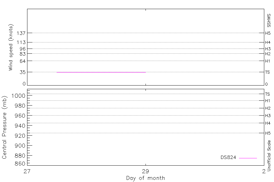
| Max Intensity |
35 kt (Feb 27 15Z) |
| End |
Feb 29 00Z |
| ATCF IDs |
SH201972 |
| Track status |
Best track data. |
|
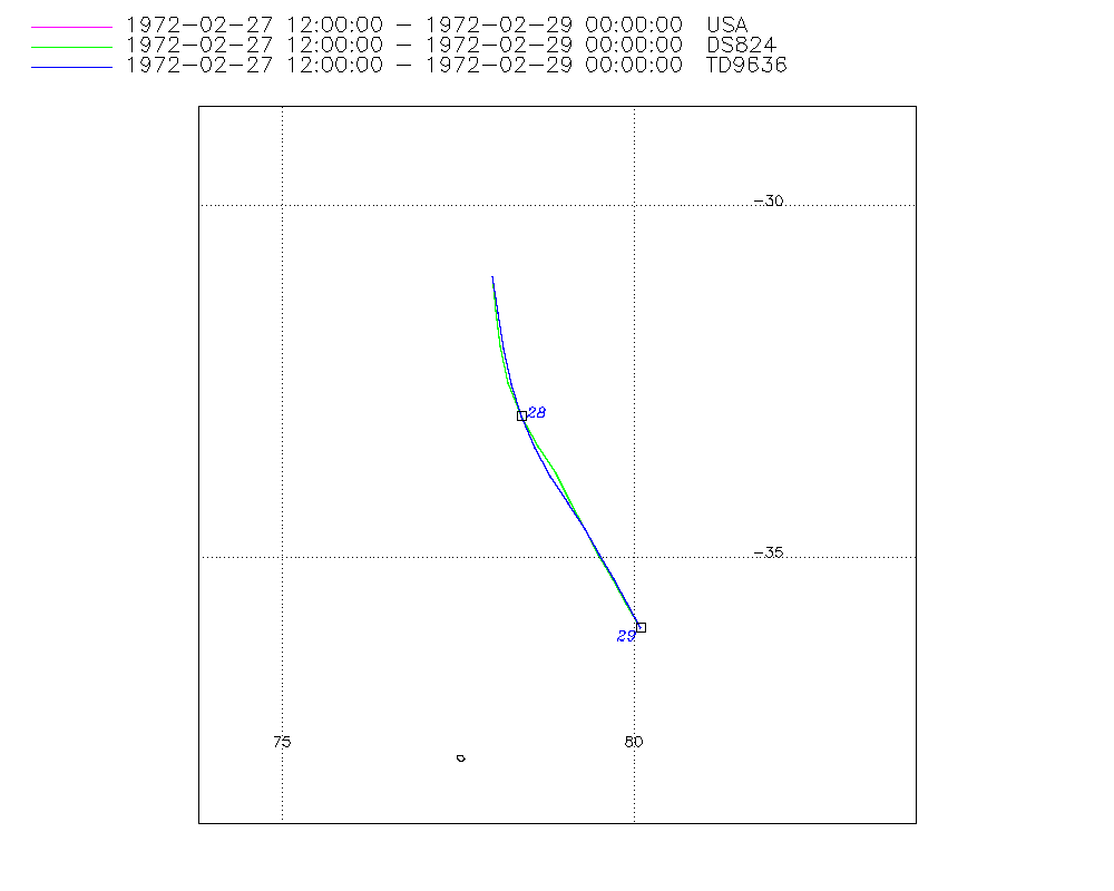
Storm track plot
|
Intensity plots
|
Radial wind information
No radial wind information for this storm
|
Position and Intensity Table
| BASIN |
ISO_TIME_________ |
NATURE |
LAT |
LON |
DS824 WIND |
| |
|
|
degrees north |
degrees east |
kts |
| SI |
1972-02-27 12:00:00 |
TS |
-31.00 |
78.00 |
35 |
| SI |
15:00:00 |
TS |
-31.50 |
78.02 |
35 |
| SI |
18:00:00 |
TS |
-32.00 |
78.09 |
35 |
| SI |
21:00:00 |
TS |
-32.52 |
78.22 |
35 |
| SI |
1972-02-28 00:00:00 |
TS |
-33.00 |
78.40 |
35 |
| SI |
03:00:00 |
TS |
-33.42 |
78.63 |
35 |
| SI |
06:00:00 |
TS |
-33.82 |
78.87 |
35 |
| SI |
09:00:00 |
TS |
-34.22 |
79.09 |
35 |
| SI |
12:00:00 |
TS |
-34.60 |
79.30 |
35 |
| SI |
15:00:00 |
TS |
-34.96 |
79.51 |
35 |
| SI |
18:00:00 |
TS |
-35.30 |
79.71 |
35 |
| SI |
21:00:00 |
TS |
-35.65 |
79.90 |
35 |
| SI |
1972-02-29 00:00:00 |
TS |
-36.00 |
80.10 |
35 |
Source Information
| Agency |
Information |
| USA |
bsh201972.txt |
| TOKYO |
|
| CMA |
|
| HKO |
|
| NEWDELHI |
|
| REUNION |
|
| BOM |
|
| NADI |
|
| WELLINGTON |
|
| DS824 |
s_hem.dat:1181:20S |
| TD9636 |
cons_worldwide_trop_cyclone_18710101-19891231-005:Line=10294 |
| TD9635 |
|
| NEUMANN |
|
| MLC |
|
All available IBTrACS Data
| SEASON |
BASIN |
SUBBASIN |
ISO_TIME_________ |
NATURE |
LAT |
LON |
DIST2LAND |
LANDFALL |
IFLAG |
USA AGENCY |
USA ATCF_ID |
USA LAT |
USA LON |
USA SSHS |
DS824 LAT |
DS824 LON |
DS824 STAGE |
DS824 WIND |
TD9636 LAT |
TD9636 LON |
TD9636 STAGE |
STORM SPEED |
STORM DIR |
| Year |
|
|
|
|
degrees north |
degrees east |
km |
km |
|
|
|
degrees north |
degrees east |
1 |
degrees north |
degrees east |
|
kts |
degrees north |
degrees east |
|
kts |
degrees |
| 1972 |
SI |
MM |
1972-02-27 12:00:00 |
TS |
-31.00 |
78.00 |
2109 |
2056 |
O________OO___ |
jtwc_sh |
SH201972 |
-31.00 |
78.00 |
-5 |
-31.00 |
78.00 |
TC |
35 |
-31.00 |
78.00 |
2 |
10 |
178 |
| 1972 |
SI |
MM |
15:00:00 |
TS |
-31.50 |
78.02 |
2056 |
2005 |
P________PP___ |
|
SH201972 |
-31.50 |
78.04 |
-5 |
-31.50 |
78.04 |
TC |
35 |
-31.52 |
78.07 |
2 |
10 |
176 |
| 1972 |
SI |
MM |
18:00:00 |
TS |
-32.00 |
78.09 |
2005 |
1954 |
O________OP___ |
jtwc_sh |
SH201972 |
-32.00 |
78.10 |
-5 |
-32.00 |
78.10 |
TC |
35 |
-32.03 |
78.15 |
2 |
10 |
170 |
| 1972 |
SI |
MM |
21:00:00 |
TS |
-32.52 |
78.22 |
1954 |
1906 |
P________PP___ |
|
SH201972 |
-32.51 |
78.22 |
-5 |
-32.51 |
78.22 |
TC |
35 |
-32.53 |
78.25 |
2 |
10 |
165 |
| 1972 |
SI |
MM |
1972-02-28 00:00:00 |
TS |
-33.00 |
78.40 |
1906 |
1869 |
O________OO___ |
jtwc_sh |
SH201972 |
-33.00 |
78.40 |
-5 |
-33.00 |
78.40 |
TC |
35 |
-33.00 |
78.40 |
2 |
10 |
159 |
| 1972 |
SI |
MM |
03:00:00 |
TS |
-33.42 |
78.63 |
1869 |
1833 |
P________PP___ |
|
SH201972 |
-33.42 |
78.64 |
-5 |
-33.42 |
78.64 |
TC |
35 |
-33.44 |
78.59 |
2 |
9 |
154 |
| 1972 |
SI |
MM |
06:00:00 |
TS |
-33.82 |
78.87 |
1836 |
1801 |
O________OP___ |
jtwc_sh |
SH201972 |
-33.80 |
78.90 |
-5 |
-33.80 |
78.90 |
TC |
35 |
-33.85 |
78.82 |
2 |
9 |
154 |
| 1972 |
SI |
MM |
09:00:00 |
TS |
-34.22 |
79.09 |
1801 |
1766 |
P________PP___ |
|
SH201972 |
-34.21 |
79.11 |
-5 |
-34.21 |
79.11 |
TC |
35 |
-34.23 |
79.06 |
2 |
9 |
156 |
| 1972 |
SI |
MM |
12:00:00 |
TS |
-34.60 |
79.30 |
1766 |
1738 |
O________OO___ |
jtwc_sh |
SH201972 |
-34.60 |
79.30 |
-5 |
-34.60 |
79.30 |
TC |
35 |
-34.60 |
79.30 |
2 |
8 |
155 |
| 1972 |
SI |
MM |
15:00:00 |
TS |
-34.96 |
79.51 |
1731 |
1707 |
P________PP___ |
|
SH201972 |
-34.96 |
79.50 |
-5 |
-34.96 |
79.50 |
TC |
35 |
-34.96 |
79.52 |
2 |
8 |
155 |
| 1972 |
SI |
MM |
18:00:00 |
TS |
-35.30 |
79.71 |
1707 |
1680 |
O________OP___ |
jtwc_sh |
SH201972 |
-35.30 |
79.70 |
-5 |
-35.30 |
79.70 |
TC |
35 |
-35.31 |
79.72 |
2 |
8 |
155 |
| 1972 |
SI |
MM |
21:00:00 |
TS |
-35.65 |
79.90 |
1674 |
1651 |
P________PP___ |
|
SH201972 |
-35.65 |
79.90 |
-5 |
-35.65 |
79.90 |
TC |
35 |
-35.66 |
79.91 |
2 |
8 |
155 |
| 1972 |
SI |
MM |
1972-02-29 00:00:00 |
TS |
-36.00 |
80.10 |
1651 |
|
O________OO___ |
jtwc_sh |
SH201972 |
-36.00 |
80.10 |
-5 |
-36.00 |
80.10 |
TC |
35 |
-36.00 |
80.10 |
2 |
8 |
156 |