1970
Tropical Depression NOT_NAMED (1970218N28285)
IBTrACS version v04r00. Visit
IBTrACS website for data access.
Please direct all questions to the
IBTrACS Q and A forum
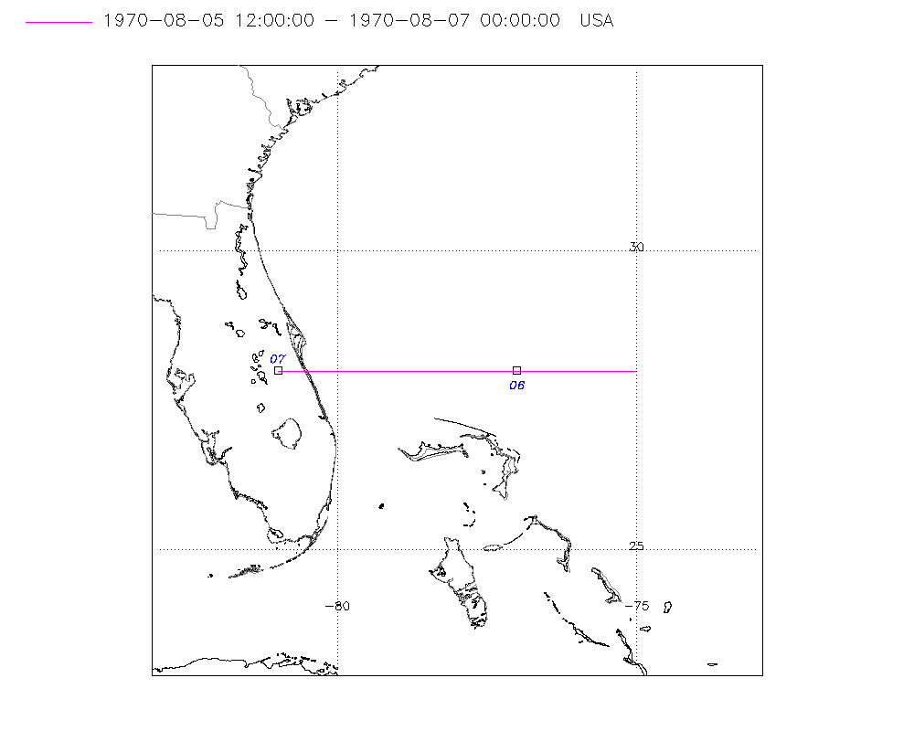
Storm track
-
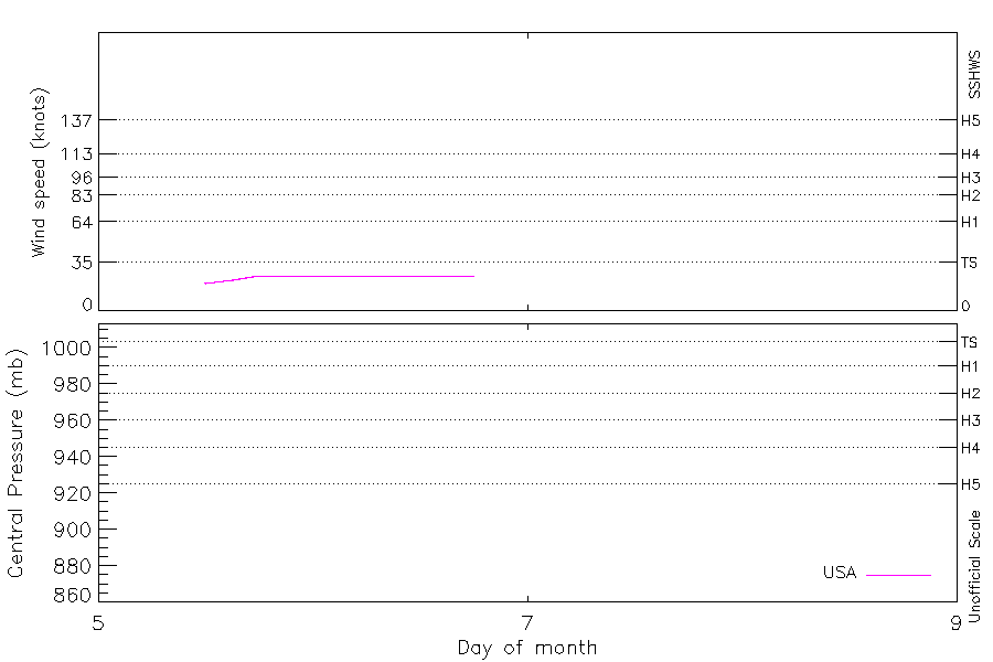
Intensity
-
Wind Radii
-
Intensity Data
-
Source Data
-
All data
Summary Information
|
|
| Storm ID |
1970218N28285 |
| Start |
Aug 5 12Z |
| Landfall |
Aug 7 00Z |
| Max Intensity |
25 kt (Aug 5 18Z) |
| End |
Aug 7 00Z |
| ATCF IDs |
AL061970 |
| Track status |
Best track data. |
|
Storm track plot
|
Intensity plots
|
Radial wind information
No radial wind information for this storm
|
Position and Intensity Table
| BASIN |
ISO_TIME_________ |
NATURE |
LAT |
LON |
WMO WIND |
USA WIND |
| |
|
|
degrees north |
degrees east |
kts |
kts |
| NA |
1970-08-05 12:00:00 |
TS |
28.00 |
-75.00 |
20 |
20 |
| NA |
15:00:00 |
TS |
28.00 |
-75.50 |
|
22 |
| NA |
18:00:00 |
TS |
28.00 |
-76.00 |
25 |
25 |
| NA |
21:00:00 |
TS |
28.00 |
-76.50 |
|
25 |
| NA |
1970-08-06 00:00:00 |
TS |
28.00 |
-77.00 |
25 |
25 |
| NA |
03:00:00 |
TS |
28.00 |
-77.50 |
|
25 |
| NA |
06:00:00 |
TS |
28.00 |
-78.00 |
25 |
25 |
| NA |
09:00:00 |
TS |
28.00 |
-78.50 |
|
25 |
| NA |
12:00:00 |
TS |
28.00 |
-79.00 |
25 |
25 |
| NA |
15:00:00 |
TS |
28.00 |
-79.50 |
|
25 |
| NA |
18:00:00 |
TS |
28.00 |
-80.00 |
25 |
25 |
| NA |
21:00:00 |
TS |
28.00 |
-80.50 |
|
|
| NA |
1970-08-07 00:00:00 |
TS |
28.00 |
-81.00 |
|
|
Source Information
| Agency |
Information |
| USA |
bal061970.dat |
| TOKYO |
|
| CMA |
|
| HKO |
|
| NEWDELHI |
|
| REUNION |
|
| BOM |
|
| NADI |
|
| WELLINGTON |
|
| DS824 |
|
| TD9636 |
|
| TD9635 |
|
| NEUMANN |
|
| MLC |
|
All available IBTrACS Data
| SEASON |
BASIN |
SUBBASIN |
ISO_TIME_________ |
NATURE |
LAT |
LON |
WMO WIND |
WMO AGENCY |
DIST2LAND |
LANDFALL |
IFLAG |
USA AGENCY |
USA ATCF_ID |
USA LAT |
USA LON |
USA STATUS |
USA WIND |
USA SSHS |
STORM SPEED |
STORM DIR |
| Year |
|
|
|
|
degrees north |
degrees east |
kts |
|
km |
km |
|
|
|
degrees north |
degrees east |
|
kts |
1 |
kts |
degrees |
| 1970 |
NA |
NA |
1970-08-05 12:00:00 |
TS |
28.00 |
-75.00 |
20 |
atcf |
440 |
408 |
O_____________ |
atcf |
AL061970 |
28.00 |
-75.00 |
TD |
20 |
-1 |
9 |
270 |
| 1970 |
NA |
NA |
15:00:00 |
TS |
28.00 |
-75.50 |
|
|
408 |
380 |
P_____________ |
|
AL061970 |
28.00 |
-75.50 |
TD |
22 |
-1 |
9 |
270 |
| 1970 |
NA |
NA |
18:00:00 |
TS |
28.00 |
-76.00 |
25 |
atcf |
380 |
356 |
O_____________ |
atcf |
AL061970 |
28.00 |
-76.00 |
TD |
25 |
-1 |
9 |
270 |
| 1970 |
NA |
NA |
21:00:00 |
TS |
28.00 |
-76.50 |
|
|
356 |
324 |
P_____________ |
|
AL061970 |
28.00 |
-76.50 |
TD |
25 |
-1 |
9 |
270 |
| 1970 |
NA |
NA |
1970-08-06 00:00:00 |
TS |
28.00 |
-77.00 |
25 |
atcf |
324 |
279 |
O_____________ |
atcf |
AL061970 |
28.00 |
-77.00 |
TD |
25 |
-1 |
9 |
270 |
| 1970 |
NA |
NA |
03:00:00 |
TS |
28.00 |
-77.50 |
|
|
279 |
234 |
P_____________ |
|
AL061970 |
28.00 |
-77.50 |
TD |
25 |
-1 |
9 |
270 |
| 1970 |
NA |
NA |
06:00:00 |
TS |
28.00 |
-78.00 |
25 |
atcf |
234 |
189 |
O_____________ |
atcf |
AL061970 |
28.00 |
-78.00 |
TD |
25 |
-1 |
9 |
270 |
| 1970 |
NA |
NA |
09:00:00 |
TS |
28.00 |
-78.50 |
|
|
189 |
144 |
P_____________ |
|
AL061970 |
28.00 |
-78.50 |
TD |
25 |
-1 |
9 |
270 |
| 1970 |
NA |
NA |
12:00:00 |
TS |
28.00 |
-79.00 |
25 |
atcf |
144 |
98 |
O_____________ |
atcf |
AL061970 |
28.00 |
-79.00 |
TD |
25 |
-1 |
9 |
270 |
| 1970 |
NA |
NA |
15:00:00 |
TS |
28.00 |
-79.50 |
|
|
98 |
50 |
P_____________ |
|
AL061970 |
28.00 |
-79.50 |
TD |
25 |
-1 |
9 |
270 |
| 1970 |
NA |
NA |
18:00:00 |
TS |
28.00 |
-80.00 |
25 |
atcf |
50 |
9 |
O_____________ |
atcf |
AL061970 |
28.00 |
-80.00 |
TD |
25 |
-1 |
9 |
270 |
| 1970 |
NA |
NA |
21:00:00 |
TS |
28.00 |
-80.50 |
|
|
9 |
0 |
P_____________ |
|
AL061970 |
28.00 |
-80.50 |
TD |
|
-5 |
9 |
270 |
| 1970 |
NA |
NA |
1970-08-07 00:00:00 |
TS |
28.00 |
-81.00 |
|
atcf |
0 |
|
O_____________ |
atcf |
AL061970 |
28.00 |
-81.00 |
TD |
|
-5 |
9 |
270 |