1967
Tropical Depression NOT_NAMED (1967278N15119)
IBTrACS version v04r00. Visit
IBTrACS website for data access.
Please direct all questions to the
IBTrACS Q and A forum
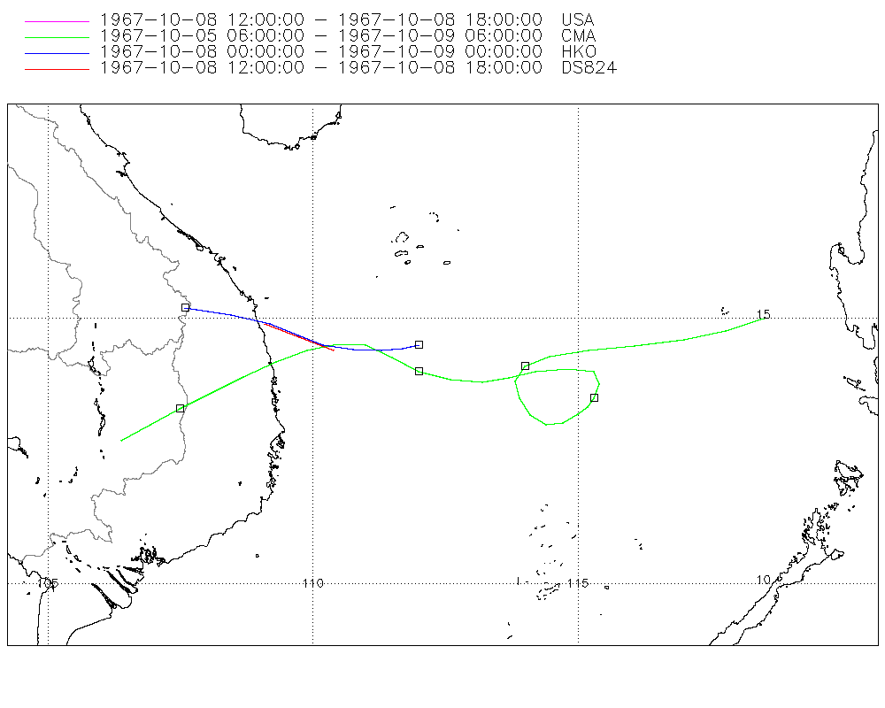
Storm track
-
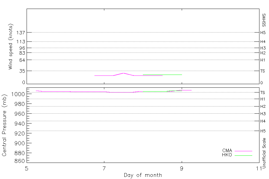
Intensity
-
Wind Radii
-
Intensity Data
-
Source Data
-
All data
Summary Information
|
|
| Storm ID |
1967278N15119 |
| Start |
Oct 5 06Z |
| Landfall |
Oct 8 18Z |
| Max Intensity |
29 kt (Oct 7 12Z) |
| End |
Oct 9 06Z |
| ATCF IDs |
,WP411967 |
| Track status |
Best track data. |
|
Storm track plot
|
Intensity plots
|
Radial wind information
No radial wind information for this storm
|
Position and Intensity Table
| BASIN |
ISO_TIME_________ |
NATURE |
LAT |
LON |
CMA WIND |
CMA PRES |
HKO WIND |
HKO PRES |
| |
|
|
degrees north |
degrees east |
kts |
mb |
kts |
mb |
| WP |
1967-10-05 06:00:00 |
TS |
15.00 |
118.50 |
|
1007 |
|
|
| WP |
09:00:00 |
TS |
14.78 |
117.79 |
|
1006 |
|
|
| WP |
12:00:00 |
TS |
14.60 |
117.00 |
|
1006 |
|
|
| WP |
15:00:00 |
TS |
14.49 |
116.08 |
|
1006 |
|
|
| WP |
18:00:00 |
TS |
14.40 |
115.20 |
|
1006 |
|
|
| WP |
21:00:00 |
TS |
14.28 |
114.47 |
|
1006 |
|
|
| WP |
1967-10-06 00:00:00 |
TS |
14.10 |
114.00 |
|
1006 |
|
|
| WP |
03:00:00 |
TS |
13.81 |
113.82 |
|
1005 |
|
|
| WP |
06:00:00 |
TS |
13.50 |
113.90 |
|
1005 |
|
|
| WP |
09:00:00 |
TS |
13.19 |
114.10 |
|
1005 |
|
|
| WP |
12:00:00 |
TS |
13.00 |
114.40 |
|
1005 |
|
|
| WP |
15:00:00 |
TS |
13.04 |
114.71 |
|
1005 |
|
|
| WP |
18:00:00 |
TS |
13.20 |
115.00 |
23 |
1005 |
|
|
| WP |
21:00:00 |
TS |
13.33 |
115.20 |
23 |
1005 |
|
|
| WP |
1967-10-07 00:00:00 |
TS |
13.50 |
115.30 |
23 |
1005 |
|
|
| WP |
03:00:00 |
TS |
13.77 |
115.40 |
23 |
1004 |
|
|
| WP |
06:00:00 |
TS |
14.00 |
115.30 |
23 |
1004 |
|
|
| WP |
09:00:00 |
TS |
14.05 |
114.83 |
26 |
1004 |
|
|
| WP |
12:00:00 |
TS |
14.00 |
114.20 |
29 |
1004 |
|
|
| WP |
15:00:00 |
TS |
13.88 |
113.71 |
26 |
1004 |
|
|
| WP |
18:00:00 |
TS |
13.80 |
113.20 |
23 |
1004 |
|
|
| WP |
21:00:00 |
TS |
13.85 |
112.60 |
23 |
1005 |
|
|
| WP |
1967-10-08 00:00:00 |
TS |
14.10 |
112.00 |
23 |
1006 |
25 |
1006 |
| WP |
03:00:00 |
TS |
14.33 |
111.56 |
23 |
1006 |
25 |
1006 |
| WP |
06:00:00 |
TS |
14.46 |
111.13 |
23 |
1006 |
25 |
1006 |
| WP |
09:00:00 |
TS |
14.47 |
110.62 |
23 |
1006 |
25 |
1006 |
| WP |
12:00:00 |
TS |
14.44 |
110.12 |
23 |
1006 |
25 |
1006 |
| WP |
15:00:00 |
TS |
14.51 |
109.60 |
|
1006 |
25 |
1006 |
| WP |
18:00:00 |
TS |
14.46 |
108.96 |
|
1006 |
25 |
1007 |
| WP |
21:00:00 |
TS |
14.09 |
108.22 |
|
1007 |
25 |
1007 |
| WP |
1967-10-09 00:00:00 |
TS |
13.78 |
107.53 |
|
1008 |
25 |
1007 |
| WP |
03:00:00 |
TS |
13.00 |
106.94 |
|
1008 |
|
|
| WP |
06:00:00 |
TS |
12.70 |
106.40 |
|
1008 |
|
|
Source Information
| Agency |
Information |
| USA |
bwp411967.txt |
| TOKYO |
|
| CMA |
CH1967BST.txt:Storm=45:(nameless) |
| HKO |
tc-besttrack-data-current.txt:Line=5234:TD1008 |
| NEWDELHI |
|
| REUNION |
|
| BOM |
|
| NADI |
|
| WELLINGTON |
|
| DS824 |
w_npac.dat:622:34W |
| TD9636 |
|
| TD9635 |
|
| NEUMANN |
|
| MLC |
|
All available IBTrACS Data
| SEASON |
BASIN |
SUBBASIN |
ISO_TIME_________ |
NATURE |
LAT |
LON |
DIST2LAND |
LANDFALL |
IFLAG |
USA AGENCY |
USA ATCF_ID |
USA LAT |
USA LON |
USA STATUS |
USA SSHS |
CMA LAT |
CMA LON |
CMA CAT |
CMA WIND |
CMA PRES |
HKO LAT |
HKO LON |
HKO CAT |
HKO WIND |
HKO PRES |
DS824 LAT |
DS824 LON |
DS824 STAGE |
STORM SPEED |
STORM DIR |
| Year |
|
|
|
|
degrees north |
degrees east |
km |
km |
|
|
|
degrees north |
degrees east |
|
1 |
degrees north |
degrees east |
1 |
kts |
mb |
degrees north |
degrees east |
|
kts |
mb |
degrees north |
degrees east |
|
kts |
degrees |
| 1967 |
WP |
MM |
1967-10-05 06:00:00 |
TS |
15.00 |
118.50 |
156 |
156 |
__O___________ |
|
|
|
|
|
-5 |
15.00 |
118.50 |
0 |
|
1007 |
|
|
|
|
|
|
|
|
14 |
252 |
| 1967 |
WP |
MM |
09:00:00 |
TS |
14.78 |
117.79 |
235 |
235 |
__P___________ |
|
|
|
|
|
-5 |
14.78 |
117.79 |
0 |
|
1006 |
|
|
|
|
|
|
|
|
15 |
255 |
| 1967 |
WP |
MM |
12:00:00 |
TS |
14.60 |
117.00 |
324 |
324 |
__O___________ |
|
|
|
|
|
-5 |
14.60 |
117.00 |
0 |
|
1006 |
|
|
|
|
|
|
|
|
17 |
260 |
| 1967 |
WP |
MM |
15:00:00 |
TS |
14.49 |
116.08 |
420 |
420 |
__P___________ |
|
|
|
|
|
-5 |
14.49 |
116.08 |
0 |
|
1006 |
|
|
|
|
|
|
|
|
18 |
263 |
| 1967 |
WP |
MM |
18:00:00 |
TS |
14.40 |
115.20 |
515 |
515 |
__O___________ |
|
|
|
|
|
-5 |
14.40 |
115.20 |
0 |
|
1006 |
|
|
|
|
|
|
|
|
16 |
262 |
| 1967 |
WP |
MM |
21:00:00 |
TS |
14.28 |
114.47 |
562 |
505 |
__P___________ |
|
|
|
|
|
-5 |
14.28 |
114.47 |
0 |
|
1006 |
|
|
|
|
|
|
|
|
12 |
256 |
| 1967 |
WP |
MM |
1967-10-06 00:00:00 |
TS |
14.10 |
114.00 |
505 |
476 |
__O___________ |
|
|
|
|
|
-5 |
14.10 |
114.00 |
0 |
|
1006 |
|
|
|
|
|
|
|
|
8 |
234 |
| 1967 |
WP |
MM |
03:00:00 |
TS |
13.81 |
113.82 |
476 |
472 |
__P___________ |
|
|
|
|
|
-5 |
13.81 |
113.82 |
0 |
|
1005 |
|
|
|
|
|
|
|
|
6 |
189 |
| 1967 |
WP |
MM |
06:00:00 |
TS |
13.50 |
113.90 |
481 |
479 |
__O___________ |
|
|
|
|
|
-5 |
13.50 |
113.90 |
0 |
|
1005 |
|
|
|
|
|
|
|
|
7 |
157 |
| 1967 |
WP |
MM |
09:00:00 |
TS |
13.19 |
114.10 |
499 |
499 |
__P___________ |
|
|
|
|
|
-5 |
13.19 |
114.10 |
0 |
|
1005 |
|
|
|
|
|
|
|
|
7 |
136 |
| 1967 |
WP |
MM |
12:00:00 |
TS |
13.00 |
114.40 |
531 |
531 |
__O___________ |
|
|
|
|
|
-5 |
13.00 |
114.40 |
0 |
|
1005 |
|
|
|
|
|
|
|
|
6 |
104 |
| 1967 |
WP |
MM |
15:00:00 |
TS |
13.04 |
114.71 |
543 |
528 |
__P___________ |
|
|
|
|
|
-5 |
13.04 |
114.71 |
0 |
|
1005 |
|
|
|
|
|
|
|
|
6 |
71 |
| 1967 |
WP |
MM |
18:00:00 |
TS |
13.20 |
115.00 |
528 |
513 |
__O___________ |
|
|
|
|
|
-5 |
13.20 |
115.00 |
1 |
23 |
1005 |
|
|
|
|
|
|
|
|
6 |
58 |
| 1967 |
WP |
MM |
21:00:00 |
TS |
13.33 |
115.20 |
513 |
509 |
__P___________ |
|
|
|
|
|
-5 |
13.33 |
115.20 |
1 |
23 |
1005 |
|
|
|
|
|
|
|
|
4 |
44 |
| 1967 |
WP |
MM |
1967-10-07 00:00:00 |
TS |
13.50 |
115.30 |
514 |
511 |
__O___________ |
|
|
|
|
|
-5 |
13.50 |
115.30 |
1 |
23 |
1005 |
|
|
|
|
|
|
|
|
5 |
25 |
| 1967 |
WP |
MM |
03:00:00 |
TS |
13.77 |
115.40 |
516 |
508 |
__P___________ |
|
|
|
|
|
-5 |
13.77 |
115.40 |
1 |
23 |
1004 |
|
|
|
|
|
|
|
|
5 |
2 |
| 1967 |
WP |
MM |
06:00:00 |
TS |
14.00 |
115.30 |
519 |
519 |
__O___________ |
|
|
|
|
|
-5 |
14.00 |
115.30 |
1 |
23 |
1004 |
|
|
|
|
|
|
|
|
6 |
297 |
| 1967 |
WP |
MM |
09:00:00 |
TS |
14.05 |
114.83 |
567 |
523 |
__P___________ |
|
|
|
|
|
-5 |
14.05 |
114.83 |
1 |
26 |
1004 |
|
|
|
|
|
|
|
|
11 |
270 |
| 1967 |
WP |
MM |
12:00:00 |
TS |
14.00 |
114.20 |
523 |
468 |
__O___________ |
|
|
|
|
|
-5 |
14.00 |
114.20 |
1 |
29 |
1004 |
|
|
|
|
|
|
|
|
11 |
261 |
| 1967 |
WP |
MM |
15:00:00 |
TS |
13.88 |
113.71 |
468 |
413 |
__P___________ |
|
|
|
|
|
-5 |
13.88 |
113.71 |
1 |
26 |
1004 |
|
|
|
|
|
|
|
|
10 |
258 |
| 1967 |
WP |
MM |
18:00:00 |
TS |
13.80 |
113.20 |
413 |
350 |
__O___________ |
|
|
|
|
|
-5 |
13.80 |
113.20 |
1 |
23 |
1004 |
|
|
|
|
|
|
|
|
11 |
268 |
| 1967 |
WP |
MM |
21:00:00 |
TS |
13.85 |
112.60 |
350 |
292 |
__P___________ |
|
|
|
|
|
-5 |
13.85 |
112.60 |
1 |
23 |
1005 |
|
|
|
|
|
|
|
|
12 |
284 |
| 1967 |
WP |
MM |
1967-10-08 00:00:00 |
TS |
14.10 |
112.00 |
292 |
252 |
__OO__________ |
|
|
|
|
|
-5 |
14.00 |
112.00 |
1 |
23 |
1006 |
14.50 |
112.00 |
TD |
25 |
1006 |
|
|
|
11 |
295 |
| 1967 |
WP |
MM |
03:00:00 |
TS |
14.33 |
111.56 |
252 |
212 |
__PP__________ |
|
|
|
|
|
-5 |
14.27 |
111.49 |
1 |
23 |
1006 |
14.44 |
111.69 |
TD |
25 |
1006 |
|
|
|
9 |
293 |
| 1967 |
WP |
MM |
06:00:00 |
TS |
14.46 |
111.13 |
205 |
155 |
__OO__________ |
|
|
|
|
|
-5 |
14.50 |
111.00 |
1 |
23 |
1006 |
14.40 |
111.30 |
TD |
25 |
1006 |
|
|
|
9 |
279 |
| 1967 |
WP |
MM |
09:00:00 |
TS |
14.47 |
110.62 |
155 |
102 |
__PP__________ |
|
|
|
|
|
-5 |
14.52 |
110.46 |
1 |
23 |
1006 |
14.41 |
110.77 |
TD |
25 |
1006 |
|
|
|
10 |
269 |
| 1967 |
WP |
MM |
12:00:00 |
TS |
14.44 |
110.12 |
102 |
53 |
O_OO_____O____ |
jtwc_wp |
WP411967 |
14.40 |
110.40 |
TD |
-5 |
14.40 |
109.90 |
1 |
23 |
1006 |
14.50 |
110.20 |
TD |
25 |
1006 |
14.40 |
110.40 |
TC |
10 |
272 |
| 1967 |
WP |
MM |
15:00:00 |
TS |
14.51 |
109.60 |
53 |
0 |
P_PP_____P____ |
|
WP411967 |
14.65 |
109.75 |
TD |
-5 |
14.19 |
109.31 |
1 |
|
1006 |
14.68 |
109.74 |
TD |
25 |
1006 |
14.65 |
109.75 |
TC |
11 |
271 |
| 1967 |
WP |
MM |
18:00:00 |
TS |
14.46 |
108.96 |
0 |
0 |
O_OO_____O____ |
jtwc_wp |
WP411967 |
14.90 |
109.10 |
TD |
-5 |
13.90 |
108.70 |
0 |
|
1006 |
14.90 |
109.20 |
TD |
25 |
1007 |
14.90 |
109.10 |
TC |
14 |
253 |
| 1967 |
WP |
MM |
21:00:00 |
TS |
14.09 |
108.22 |
0 |
0 |
__PP__________ |
|
WP411967 |
|
|
TD |
-5 |
13.61 |
108.09 |
0 |
|
1007 |
15.07 |
108.46 |
TD |
25 |
1007 |
|
|
TC |
15 |
244 |
| 1967 |
WP |
MM |
1967-10-09 00:00:00 |
TS |
13.78 |
107.53 |
0 |
0 |
__OO__________ |
|
|
|
|
|
-5 |
13.30 |
107.50 |
0 |
|
1008 |
15.20 |
107.60 |
TD |
25 |
1007 |
|
|
|
17 |
228 |
| 1967 |
WP |
MM |
03:00:00 |
TS |
13.00 |
106.94 |
0 |
0 |
__P___________ |
|
|
|
|
|
-5 |
13.00 |
106.94 |
0 |
|
1008 |
|
|
TD |
|
|
|
|
|
15 |
226 |
| 1967 |
WP |
MM |
06:00:00 |
TS |
12.70 |
106.40 |
0 |
|
__O___________ |
|
|
|
|
|
-5 |
12.70 |
106.40 |
0 |
|
1008 |
|
|
|
|
|
|
|
|
12 |
241 |