1967
Tropical Depression NOT_NAMED (1967201N26134)
IBTrACS version v04r00. Visit
IBTrACS website for data access.
Please direct all questions to the
IBTrACS Q and A forum
Storm track
-
Intensity
-
Wind Radii
-
Intensity Data
-
Source Data
-
All data
Summary Information
|
|
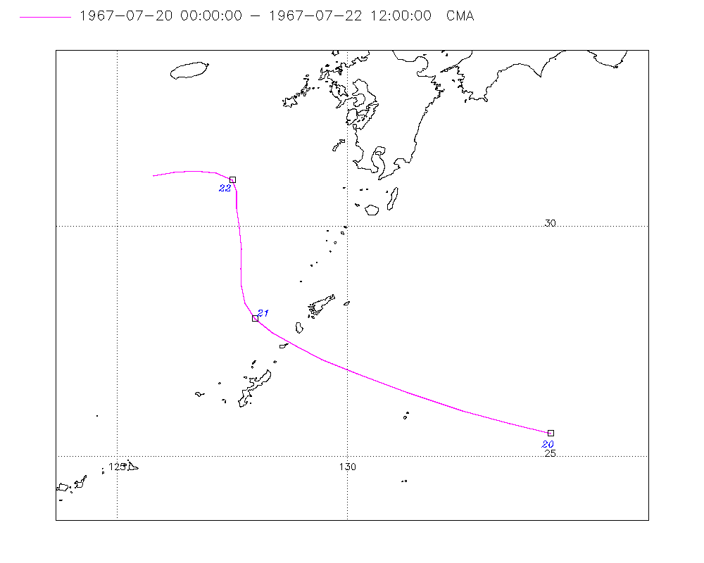
| Storm ID |
1967201N26134 |
| Start |
Jul 20 00Z |
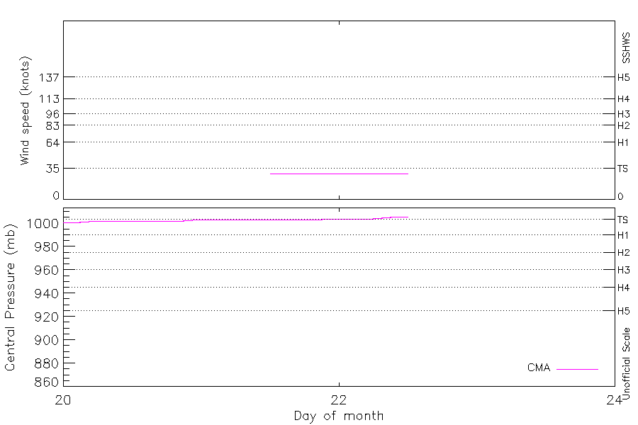
| Max Intensity |
29 kt (Jul 21 12Z) |
| End |
Jul 22 12Z |
| ATCF IDs |
|
| Track status |
Best track data. |
|
Storm track plot
|
Intensity plots
|
Radial wind information
No radial wind information for this storm
|
Position and Intensity Table
| BASIN |
ISO_TIME_________ |
NATURE |
LAT |
LON |
CMA WIND |
CMA PRES |
| |
|
|
degrees north |
degrees east |
kts |
mb |
| WP |
1967-07-20 00:00:00 |
TS |
25.50 |
134.40 |
|
1001 |
| WP |
03:00:00 |
TS |
25.71 |
133.51 |
|
1001 |
| WP |
06:00:00 |
TS |
26.00 |
132.50 |
|
1002 |
| WP |
09:00:00 |
TS |
26.39 |
131.31 |
|
1002 |
| WP |
12:00:00 |
TS |
26.80 |
130.20 |
|
1002 |
| WP |
15:00:00 |
TS |
27.11 |
129.44 |
|
1002 |
| WP |
18:00:00 |
TS |
27.40 |
128.90 |
|
1002 |
| WP |
21:00:00 |
TS |
27.69 |
128.37 |
|
1002 |
| WP |
1967-07-21 00:00:00 |
TS |
28.00 |
128.00 |
|
1003 |
| WP |
03:00:00 |
TS |
28.33 |
127.78 |
|
1003 |
| WP |
06:00:00 |
TS |
28.70 |
127.70 |
|
1003 |
| WP |
09:00:00 |
TS |
29.08 |
127.68 |
|
1003 |
| WP |
12:00:00 |
TS |
29.50 |
127.70 |
29 |
1003 |
| WP |
15:00:00 |
TS |
29.97 |
127.66 |
29 |
1003 |
| WP |
18:00:00 |
TS |
30.40 |
127.60 |
29 |
1003 |
| WP |
21:00:00 |
TS |
30.75 |
127.60 |
29 |
1003 |
| WP |
1967-07-22 00:00:00 |
TS |
31.00 |
127.50 |
29 |
1004 |
| WP |
03:00:00 |
TS |
31.15 |
127.16 |
29 |
1004 |
| WP |
06:00:00 |
TS |
31.20 |
126.70 |
29 |
1004 |
| WP |
09:00:00 |
TS |
31.17 |
126.24 |
29 |
1005 |
| WP |
12:00:00 |
TS |
31.10 |
125.80 |
29 |
1006 |
Source Information
| Agency |
Information |
| USA |
|
| TOKYO |
|
| CMA |
CH1967BST.txt:Storm=12:(nameless) |
| HKO |
|
| NEWDELHI |
|
| REUNION |
|
| BOM |
|
| NADI |
|
| WELLINGTON |
|
| DS824 |
|
| TD9636 |
|
| TD9635 |
|
| NEUMANN |
|
| MLC |
|
All available IBTrACS Data
| SEASON |
BASIN |
SUBBASIN |
ISO_TIME_________ |
NATURE |
LAT |
LON |
DIST2LAND |
LANDFALL |
IFLAG |
USA SSHS |
CMA LAT |
CMA LON |
CMA CAT |
CMA WIND |
CMA PRES |
STORM SPEED |
STORM DIR |
| Year |
|
|
|
|
degrees north |
degrees east |
km |
km |
|
1 |
degrees north |
degrees east |
1 |
kts |
mb |
kts |
degrees |
| 1967 |
WP |
MM |
1967-07-20 00:00:00 |
TS |
25.50 |
134.40 |
712 |
656 |
__O___________ |
-5 |
25.50 |
134.40 |
0 |
|
1001 |
17 |
285 |
| 1967 |
WP |
MM |
03:00:00 |
TS |
25.71 |
133.51 |
651 |
588 |
__P___________ |
-5 |
25.71 |
133.51 |
0 |
|
1001 |
18 |
286 |
| 1967 |
WP |
MM |
06:00:00 |
TS |
26.00 |
132.50 |
585 |
518 |
__O___________ |
-5 |
26.00 |
132.50 |
0 |
|
1002 |
21 |
289 |
| 1967 |
WP |
MM |
09:00:00 |
TS |
26.39 |
131.31 |
516 |
470 |
__P___________ |
-5 |
26.39 |
131.31 |
0 |
|
1002 |
22 |
291 |
| 1967 |
WP |
MM |
12:00:00 |
TS |
26.80 |
130.20 |
471 |
450 |
__O___________ |
-5 |
26.80 |
130.20 |
0 |
|
1002 |
18 |
293 |
| 1967 |
WP |
MM |
15:00:00 |
TS |
27.11 |
129.44 |
453 |
434 |
__P___________ |
-5 |
27.11 |
129.44 |
0 |
|
1002 |
13 |
297 |
| 1967 |
WP |
MM |
18:00:00 |
TS |
27.40 |
128.90 |
438 |
427 |
__O___________ |
-5 |
27.40 |
128.90 |
0 |
|
1002 |
11 |
301 |
| 1967 |
WP |
MM |
21:00:00 |
TS |
27.69 |
128.37 |
427 |
415 |
__P___________ |
-5 |
27.69 |
128.37 |
0 |
|
1002 |
10 |
307 |
| 1967 |
WP |
MM |
1967-07-21 00:00:00 |
TS |
28.00 |
128.00 |
415 |
397 |
__O___________ |
-5 |
28.00 |
128.00 |
0 |
|
1003 |
8 |
321 |
| 1967 |
WP |
MM |
03:00:00 |
TS |
28.33 |
127.78 |
397 |
368 |
__P___________ |
-5 |
28.33 |
127.78 |
0 |
|
1003 |
8 |
339 |
| 1967 |
WP |
MM |
06:00:00 |
TS |
28.70 |
127.70 |
368 |
335 |
__O___________ |
-5 |
28.70 |
127.70 |
0 |
|
1003 |
8 |
353 |
| 1967 |
WP |
MM |
09:00:00 |
TS |
29.08 |
127.68 |
335 |
305 |
__P___________ |
-5 |
29.08 |
127.68 |
0 |
|
1003 |
8 |
1 |
| 1967 |
WP |
MM |
12:00:00 |
TS |
29.50 |
127.70 |
305 |
279 |
__O___________ |
-5 |
29.50 |
127.70 |
1 |
29 |
1003 |
9 |
359 |
| 1967 |
WP |
MM |
15:00:00 |
TS |
29.97 |
127.66 |
273 |
263 |
__P___________ |
-5 |
29.97 |
127.66 |
1 |
29 |
1003 |
9 |
355 |
| 1967 |
WP |
MM |
18:00:00 |
TS |
30.40 |
127.60 |
263 |
253 |
__O___________ |
-5 |
30.40 |
127.60 |
1 |
29 |
1003 |
8 |
357 |
| 1967 |
WP |
MM |
21:00:00 |
TS |
30.75 |
127.60 |
251 |
249 |
__P___________ |
-5 |
30.75 |
127.60 |
1 |
29 |
1003 |
6 |
352 |
| 1967 |
WP |
MM |
1967-07-22 00:00:00 |
TS |
31.00 |
127.50 |
257 |
240 |
__O___________ |
-5 |
31.00 |
127.50 |
1 |
29 |
1004 |
6 |
317 |
| 1967 |
WP |
MM |
03:00:00 |
TS |
31.15 |
127.16 |
230 |
223 |
__P___________ |
-5 |
31.15 |
127.16 |
1 |
29 |
1004 |
7 |
286 |
| 1967 |
WP |
MM |
06:00:00 |
TS |
31.20 |
126.70 |
223 |
223 |
__O___________ |
-5 |
31.20 |
126.70 |
1 |
29 |
1004 |
8 |
271 |
| 1967 |
WP |
MM |
09:00:00 |
TS |
31.17 |
126.24 |
223 |
223 |
__P___________ |
-5 |
31.17 |
126.24 |
1 |
29 |
1005 |
8 |
263 |
| 1967 |
WP |
MM |
12:00:00 |
TS |
31.10 |
125.80 |
238 |
|
__O___________ |
-5 |
31.10 |
125.80 |
1 |
29 |
1006 |
8 |
260 |