1966
Tropical Depression NOT_NAMED (1966055S21429)
IBTrACS version v04r00. Visit
IBTrACS website for data access.
Please direct all questions to the
IBTrACS Q and A forum
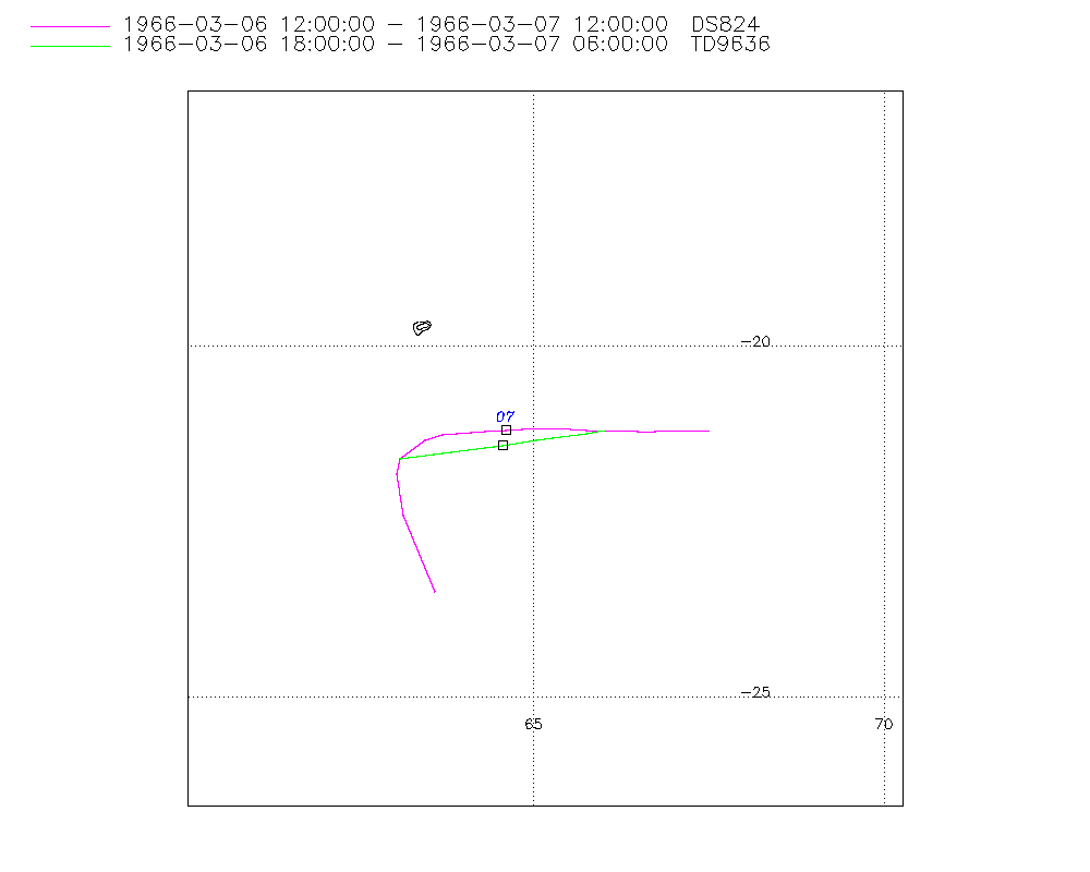
Storm track
-
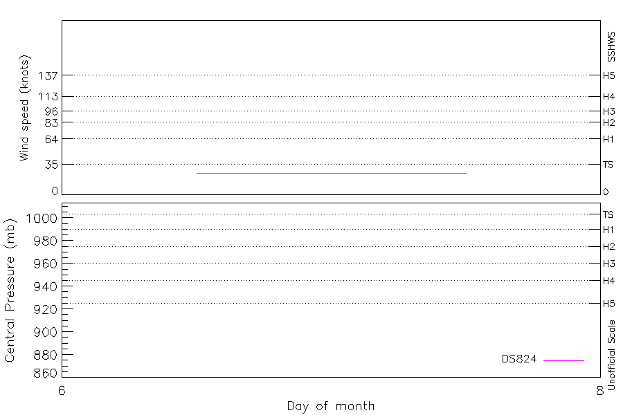
Intensity
-
Wind Radii
-
Intensity Data
-
Source Data
-
All data
Summary Information
|
|
| Storm ID |
1966055S21429 |
| Start |
Mar 6 07Z |
| Max Intensity |
25 kt (Mar 6 12Z) |
| End |
Mar 7 12Z |
| ATCF IDs |
|
| Track status |
Best track data. |
|
Storm track plot
|
Intensity plots
|
Radial wind information
No radial wind information for this storm
|
Position and Intensity Table
| BASIN |
ISO_TIME_________ |
NATURE |
LAT |
LON |
DS824 WIND |
| |
|
|
degrees north |
degrees east |
kts |
| SI |
1966-03-06 07:00:00 |
TS |
-21.19 |
68.66 |
|
| SI |
09:00:00 |
TS |
-21.17 |
68.18 |
|
| SI |
12:00:00 |
TS |
-21.17 |
67.47 |
25 |
| SI |
15:00:00 |
TS |
-21.18 |
66.73 |
25 |
| SI |
16:00:00 |
TS |
-21.18 |
66.49 |
25 |
| SI |
18:00:00 |
TS |
-21.20 |
66.00 |
25 |
| SI |
19:00:00 |
TS |
-21.18 |
65.73 |
25 |
| SI |
21:00:00 |
TS |
-21.14 |
65.17 |
25 |
| SI |
22:00:00 |
TS |
-21.13 |
64.90 |
25 |
| SI |
1966-03-07 00:00:00 |
TS |
-21.14 |
64.36 |
25 |
| SI |
01:00:00 |
TS |
-21.15 |
64.08 |
25 |
| SI |
03:00:00 |
TS |
-21.23 |
63.56 |
25 |
| SI |
04:00:00 |
TS |
-21.31 |
63.35 |
25 |
| SI |
06:00:00 |
TS |
-21.60 |
63.10 |
25 |
| SI |
07:00:00 |
TS |
-21.83 |
63.07 |
25 |
| SI |
09:00:00 |
TS |
-22.43 |
63.19 |
25 |
| SI |
12:00:00 |
TS |
-23.55 |
63.77 |
25 |
Source Information
| Agency |
Information |
| USA |
|
| TOKYO |
|
| CMA |
|
| HKO |
|
| NEWDELHI |
|
| REUNION |
|
| BOM |
|
| NADI |
|
| WELLINGTON |
|
| DS824 |
s_hem.dat:1000:28S |
| TD9636 |
cons_worldwide_trop_cyclone_18710101-19891231-005:Line=8936 |
| TD9635 |
|
| NEUMANN |
|
| MLC |
|
All available IBTrACS Data
| SEASON |
BASIN |
SUBBASIN |
ISO_TIME_________ |
NATURE |
LAT |
LON |
DIST2LAND |
LANDFALL |
IFLAG |
USA SSHS |
DS824 LAT |
DS824 LON |
DS824 STAGE |
DS824 WIND |
TD9636 LAT |
TD9636 LON |
TD9636 STAGE |
STORM SPEED |
STORM DIR |
| Year |
|
|
|
|
degrees north |
degrees east |
km |
km |
|
1 |
degrees north |
degrees east |
|
kts |
degrees north |
degrees east |
|
kts |
degrees |
| 1966 |
SI |
MM |
1966-03-06 07:00:00 |
TS |
-21.19 |
68.66 |
1137 |
1085 |
______________ |
-5 |
|
|
|
|
|
|
|
13 |
272 |
| 1966 |
SI |
MM |
09:00:00 |
TS |
-21.17 |
68.18 |
1085 |
1013 |
______________ |
-5 |
|
|
|
|
|
|
|
13 |
271 |
| 1966 |
SI |
MM |
12:00:00 |
TS |
-21.17 |
67.47 |
1013 |
930 |
_________O____ |
-5 |
-21.20 |
67.50 |
TC |
25 |
|
|
|
14 |
270 |
| 1966 |
SI |
MM |
15:00:00 |
TS |
-21.18 |
66.73 |
930 |
909 |
_________P____ |
-5 |
-21.21 |
66.74 |
TC |
25 |
|
|
|
14 |
269 |
| 1966 |
SI |
MM |
16:00:00 |
TS |
-21.18 |
66.49 |
909 |
858 |
_________P____ |
-5 |
-21.21 |
66.49 |
TC |
25 |
|
|
|
14 |
268 |
| 1966 |
SI |
MM |
18:00:00 |
TS |
-21.20 |
66.00 |
858 |
837 |
_________OO___ |
-5 |
-21.20 |
66.00 |
TC |
25 |
-21.20 |
66.00 |
1 |
14 |
270 |
| 1966 |
SI |
MM |
19:00:00 |
TS |
-21.18 |
65.73 |
827 |
774 |
_________PP___ |
-5 |
-21.19 |
65.76 |
TC |
25 |
-21.24 |
65.76 |
1 |
16 |
274 |
| 1966 |
SI |
MM |
21:00:00 |
TS |
-21.14 |
65.17 |
774 |
743 |
_________PP___ |
-5 |
-21.17 |
65.30 |
TC |
25 |
-21.30 |
65.28 |
1 |
16 |
274 |
| 1966 |
SI |
MM |
22:00:00 |
TS |
-21.13 |
64.90 |
743 |
692 |
_________PP___ |
-5 |
-21.17 |
65.07 |
TC |
25 |
-21.34 |
65.04 |
1 |
15 |
270 |
| 1966 |
SI |
MM |
1966-03-07 00:00:00 |
TS |
-21.14 |
64.36 |
692 |
661 |
_________OP___ |
-5 |
-21.20 |
64.60 |
TC |
25 |
-21.41 |
64.55 |
1 |
15 |
268 |
| 1966 |
SI |
MM |
01:00:00 |
TS |
-21.15 |
64.08 |
661 |
611 |
_________PP___ |
-5 |
-21.20 |
64.30 |
TC |
25 |
-21.44 |
64.31 |
1 |
15 |
263 |
| 1966 |
SI |
MM |
03:00:00 |
TS |
-21.23 |
63.56 |
611 |
592 |
_________PP___ |
-5 |
-21.26 |
63.71 |
TC |
25 |
-21.50 |
63.83 |
1 |
14 |
256 |
| 1966 |
SI |
MM |
04:00:00 |
TS |
-21.31 |
63.35 |
592 |
566 |
_________PP___ |
-5 |
-21.33 |
63.45 |
TC |
25 |
-21.54 |
63.58 |
1 |
11 |
229 |
| 1966 |
SI |
MM |
06:00:00 |
TS |
-21.60 |
63.10 |
569 |
569 |
_________OO___ |
-5 |
-21.60 |
63.10 |
TC |
25 |
-21.60 |
63.10 |
1 |
12 |
207 |
| 1966 |
SI |
MM |
07:00:00 |
TS |
-21.83 |
63.07 |
574 |
574 |
_________P____ |
-5 |
-21.82 |
63.04 |
TC |
25 |
|
|
1 |
17 |
174 |
| 1966 |
SI |
MM |
09:00:00 |
TS |
-22.43 |
63.19 |
606 |
610 |
_________P____ |
-5 |
-22.41 |
63.14 |
TC |
25 |
|
|
1 |
22 |
159 |
| 1966 |
SI |
MM |
12:00:00 |
TS |
-23.55 |
63.77 |
717 |
|
_________O____ |
-5 |
-23.50 |
63.60 |
TC |
25 |
|
|
1 |
25 |
154 |