1959
Tropical Storm OPAL:RUTH (1959248N09160)
IBTrACS version v04r00. Visit
IBTrACS website for data access.
Please direct all questions to the
IBTrACS Q and A forum
Storm track
-
Intensity
-
Wind Radii
-
Intensity Data
-
Source Data
-
All data
Summary Information
|
|
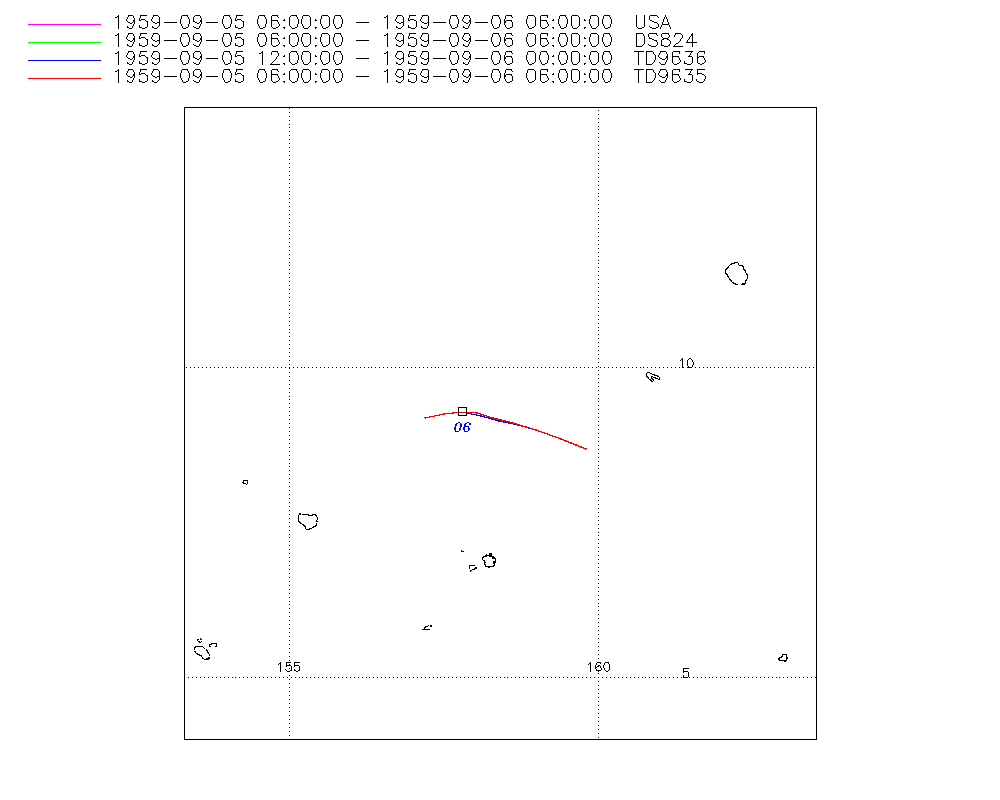
| Storm ID |
1959248N09160 |
| Start |
Sep 5 06Z |
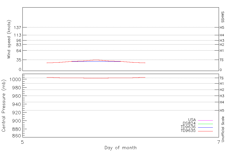
| Max Intensity |
35 kt (Sep 5 18Z) |
| End |
Sep 6 06Z |
| ATCF IDs |
WP131959 |
| Track status |
Best track data. |
|
Storm track plot
|
Intensity plots
|
Radial wind information
|
Position and Intensity Table
| BASIN |
ISO_TIME_________ |
NATURE |
LAT |
LON |
USA WIND |
DS824 WIND |
TD9636 WIND |
TD9635 WIND |
TD9635 PRES |
| |
|
|
degrees north |
degrees east |
kts |
kts |
kts |
kts |
mb |
| WP |
1959-09-05 06:00:00 |
TS |
8.70 |
159.80 |
25 |
25 |
|
25 |
1005 |
| WP |
09:00:00 |
TS |
8.86 |
159.40 |
27 |
27 |
|
27 |
1004 |
| WP |
12:00:00 |
TS |
9.00 |
159.00 |
30 |
30 |
30 |
30 |
1004 |
| WP |
15:00:00 |
TS |
9.11 |
158.64 |
32 |
32 |
30 |
32 |
1003 |
| WP |
18:00:00 |
TS |
9.19 |
158.32 |
35 |
35 |
30 |
35 |
1003 |
| WP |
21:00:00 |
TS |
9.27 |
158.05 |
32 |
32 |
30 |
32 |
1003 |
| WP |
1959-09-06 00:00:00 |
TS |
9.30 |
157.80 |
30 |
30 |
30 |
30 |
1004 |
| WP |
03:00:00 |
TS |
9.27 |
157.51 |
27 |
27 |
|
27 |
1004 |
| WP |
06:00:00 |
TS |
9.20 |
157.20 |
25 |
25 |
|
25 |
1005 |
Source Information
| Agency |
Information |
| USA |
bwp131959.txt |
| TOKYO |
|
| CMA |
|
| HKO |
|
| NEWDELHI |
|
| REUNION |
|
| BOM |
|
| NADI |
|
| WELLINGTON |
|
| DS824 |
w_npac.dat:318:RUTH |
| TD9636 |
cons_worldwide_trop_cyclone_18710101-19891231-003:Line=18355 |
| TD9635 |
typhoons-analogs_19450101-19761231.corrected:Line=9144 |
| NEUMANN |
|
| MLC |
|
All available IBTrACS Data
| SEASON |
BASIN |
SUBBASIN |
ISO_TIME_________ |
NATURE |
LAT |
LON |
DIST2LAND |
LANDFALL |
IFLAG |
USA AGENCY |
USA ATCF_ID |
USA LAT |
USA LON |
USA WIND |
USA SSHS |
DS824 LAT |
DS824 LON |
DS824 STAGE |
DS824 WIND |
TD9636 LAT |
TD9636 LON |
TD9636 STAGE |
TD9636 WIND |
TD9635 LAT |
TD9635 LON |
TD9635 WIND |
TD9635 PRES |
TD9635 ROCI |
STORM SPEED |
STORM DIR |
| Year |
|
|
|
|
degrees north |
degrees east |
km |
km |
|
|
|
degrees north |
degrees east |
kts |
1 |
degrees north |
degrees east |
|
kts |
degrees north |
degrees east |
|
kts |
degrees north |
degrees east |
kts |
mb |
nmile |
kts |
degrees |
| 1959 |
WP |
MM |
1959-09-05 06:00:00 |
TS |
8.70 |
159.80 |
1599 |
1585 |
O________O_O__ |
jtwc_wp |
WP131959 |
8.70 |
159.80 |
25 |
-1 |
8.70 |
159.80 |
TC |
25 |
|
|
|
|
8.70 |
159.80 |
25 |
1005 |
60 |
9 |
292 |
| 1959 |
WP |
MM |
09:00:00 |
TS |
8.86 |
159.40 |
1594 |
1581 |
P________P_P__ |
|
WP131959 |
8.86 |
159.40 |
27 |
-1 |
8.86 |
159.40 |
TC |
27 |
|
|
|
|
8.86 |
159.40 |
27 |
1004 |
60 |
8 |
291 |
| 1959 |
WP |
MM |
12:00:00 |
TS |
9.00 |
159.00 |
1581 |
1573 |
O________OOO__ |
jtwc_wp |
WP131959 |
9.00 |
159.00 |
30 |
-1 |
9.00 |
159.00 |
TC |
30 |
9.00 |
159.00 |
1 |
30 |
9.00 |
159.00 |
30 |
1004 |
60 |
8 |
289 |
| 1959 |
WP |
MM |
15:00:00 |
TS |
9.11 |
158.64 |
1568 |
1561 |
P________PPP__ |
|
WP131959 |
9.11 |
158.63 |
32 |
-1 |
9.11 |
158.63 |
TC |
32 |
9.08 |
158.70 |
1 |
30 |
9.11 |
158.63 |
32 |
1003 |
60 |
7 |
286 |
| 1959 |
WP |
MM |
18:00:00 |
TS |
9.19 |
158.32 |
1561 |
1550 |
O________OPO__ |
jtwc_wp |
WP131959 |
9.20 |
158.30 |
35 |
0 |
9.20 |
158.30 |
TC |
35 |
9.15 |
158.40 |
1 |
30 |
9.20 |
158.30 |
35 |
1003 |
60 |
6 |
285 |
| 1959 |
WP |
MM |
21:00:00 |
TS |
9.27 |
158.05 |
1560 |
1545 |
P________PPP__ |
|
WP131959 |
9.27 |
158.04 |
32 |
-1 |
9.27 |
158.04 |
TC |
32 |
9.23 |
158.10 |
1 |
30 |
9.27 |
158.04 |
32 |
1003 |
60 |
5 |
282 |
| 1959 |
WP |
MM |
1959-09-06 00:00:00 |
TS |
9.30 |
157.80 |
1545 |
1530 |
O________OOO__ |
jtwc_wp |
WP131959 |
9.30 |
157.80 |
30 |
-1 |
9.30 |
157.80 |
TC |
30 |
9.30 |
157.80 |
1 |
30 |
9.30 |
157.80 |
30 |
1004 |
60 |
5 |
270 |
| 1959 |
WP |
MM |
03:00:00 |
TS |
9.27 |
157.51 |
1530 |
1505 |
P________P_P__ |
|
WP131959 |
9.27 |
157.51 |
27 |
-1 |
9.27 |
157.51 |
TC |
27 |
|
|
1 |
|
9.27 |
157.51 |
27 |
1004 |
60 |
6 |
260 |
| 1959 |
WP |
MM |
06:00:00 |
TS |
9.20 |
157.20 |
1505 |
|
O________O_O__ |
jtwc_wp |
WP131959 |
9.20 |
157.20 |
25 |
-1 |
9.20 |
157.20 |
TC |
25 |
|
|
1 |
|
9.20 |
157.20 |
25 |
1005 |
60 |
6 |
258 |