1959
Tropical Cyclone BEATRICE (1959017S20165)
IBTrACS version v04r00. Visit
IBTrACS website for data access.
Please direct all questions to the
IBTrACS Q and A forum
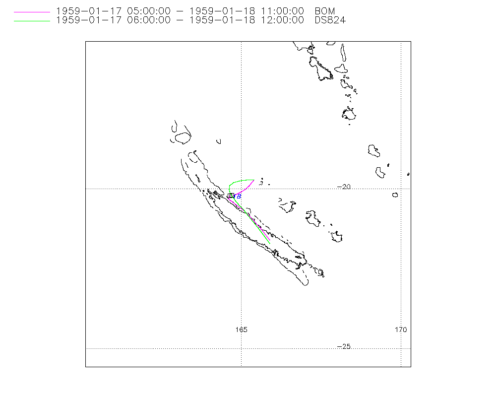
Storm track
-
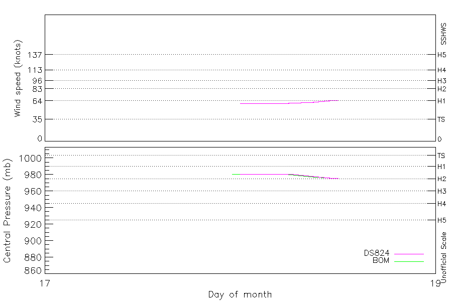
Intensity
-
Wind Radii
-
Intensity Data
-
Source Data
-
All data
Summary Information
|
|
| Storm ID |
1959017S20165 |
| Start |
Jan 17 05Z |
| Landfall |
Jan 18 06Z |
| Max Intensity |
65 kt (Jan 18 12Z), 976 mb (Jan 18 11Z) |
| End |
Jan 18 12Z |
| ATCF IDs |
|
| Track status |
Best track data. |
|
Storm track plot
|
Intensity plots
|
Radial wind information
No radial wind information for this storm
|
Position and Intensity Table
| BASIN |
ISO_TIME_________ |
NATURE |
LAT |
LON |
WMO PRES |
BOM PRES |
DS824 WIND |
DS824 PRES |
| |
|
|
degrees north |
degrees east |
mb |
mb |
kts |
mb |
| SP |
1959-01-17 05:00:00 |
TS |
-19.59 |
165.35 |
990 |
990 |
|
|
| SP |
06:00:00 |
TS |
-19.80 |
165.44 |
|
|
45 |
990 |
| SP |
09:00:00 |
TS |
-20.21 |
165.52 |
|
|
|
|
| SP |
11:00:00 |
TS |
-20.33 |
165.46 |
|
|
|
|
| SP |
12:00:00 |
TS |
-20.35 |
165.41 |
|
|
|
|
| SP |
15:00:00 |
TS |
-20.33 |
165.20 |
|
|
|
|
| SP |
18:00:00 |
TS |
-20.24 |
164.96 |
|
|
|
|
| SP |
21:00:00 |
TS |
-20.17 |
164.76 |
|
|
|
|
| SP |
23:00:00 |
TS |
-20.18 |
164.69 |
981 |
981 |
|
|
| SP |
1959-01-18 00:00:00 |
TS |
-20.21 |
164.67 |
|
981 |
60 |
981 |
| SP |
02:00:00 |
TS |
-20.33 |
164.71 |
981 |
981 |
60 |
981 |
| SP |
03:00:00 |
TS |
-20.42 |
164.80 |
|
981 |
60 |
981 |
| SP |
05:00:00 |
TS |
-20.64 |
165.05 |
981 |
981 |
60 |
981 |
| SP |
06:00:00 |
TS |
-20.77 |
165.18 |
|
980 |
60 |
981 |
| SP |
09:00:00 |
TS |
-21.26 |
165.59 |
|
977 |
62 |
978 |
| SP |
11:00:00 |
TS |
-21.58 |
165.85 |
976 |
976 |
64 |
976 |
| SP |
12:00:00 |
TS |
-21.70 |
165.96 |
|
|
65 |
976 |
Source Information
| Agency |
Information |
| USA |
|
| TOKYO |
|
| CMA |
|
| HKO |
|
| NEWDELHI |
|
| REUNION |
|
| BOM |
IDCKMSTM0S.csv:Line=2780:BEATRICE |
| NADI |
|
| WELLINGTON |
|
| DS824 |
aus_area.dat:275:NOT NAMED |
| TD9636 |
|
| TD9635 |
|
| NEUMANN |
|
| MLC |
|
All available IBTrACS Data
| SEASON |
BASIN |
SUBBASIN |
ISO_TIME_________ |
NATURE |
LAT |
LON |
WMO PRES |
WMO AGENCY |
DIST2LAND |
LANDFALL |
IFLAG |
USA SSHS |
BOM LAT |
BOM LON |
BOM PRES |
DS824 LAT |
DS824 LON |
DS824 STAGE |
DS824 WIND |
DS824 PRES |
STORM SPEED |
STORM DIR |
| Year |
|
|
|
|
degrees north |
degrees east |
mb |
|
km |
km |
|
1 |
degrees north |
degrees east |
mb |
degrees north |
degrees east |
|
kts |
mb |
kts |
degrees |
| 1959 |
SP |
MM |
1959-01-17 05:00:00 |
TS |
-19.59 |
165.35 |
990 |
bom |
114 |
107 |
______O_______ |
-5 |
-19.70 |
165.40 |
990 |
|
|
|
|
|
14 |
157 |
| 1959 |
SP |
MM |
06:00:00 |
TS |
-19.80 |
165.44 |
|
|
107 |
74 |
______P__O____ |
-5 |
-19.73 |
165.38 |
|
-19.70 |
165.40 |
TC |
45 |
990 |
10 |
166 |
| 1959 |
SP |
MM |
09:00:00 |
TS |
-20.21 |
165.52 |
|
|
74 |
64 |
______P__P____ |
-5 |
-19.83 |
165.30 |
|
-19.72 |
165.16 |
TC |
|
|
6 |
179 |
| 1959 |
SP |
MM |
11:00:00 |
TS |
-20.33 |
165.46 |
|
|
64 |
49 |
______P__P____ |
-5 |
-19.89 |
165.25 |
|
-19.73 |
165.00 |
TC |
|
|
4 |
215 |
| 1959 |
SP |
MM |
12:00:00 |
TS |
-20.35 |
165.41 |
|
|
49 |
45 |
______P__P____ |
-5 |
-19.92 |
165.22 |
|
-19.74 |
164.93 |
TC |
|
|
4 |
269 |
| 1959 |
SP |
MM |
15:00:00 |
TS |
-20.33 |
165.20 |
|
|
53 |
38 |
______P__P____ |
-5 |
-20.01 |
165.12 |
|
-19.79 |
164.75 |
TC |
|
|
4 |
285 |
| 1959 |
SP |
MM |
18:00:00 |
TS |
-20.24 |
164.96 |
|
|
45 |
30 |
______P__P____ |
-5 |
-20.09 |
164.99 |
|
-19.88 |
164.64 |
TC |
|
|
4 |
292 |
| 1959 |
SP |
MM |
21:00:00 |
TS |
-20.17 |
164.76 |
|
|
30 |
23 |
______P__P____ |
-5 |
-20.16 |
164.83 |
|
-20.01 |
164.61 |
TC |
|
|
3 |
284 |
| 1959 |
SP |
MM |
23:00:00 |
TS |
-20.18 |
164.69 |
981 |
bom |
23 |
23 |
______O__P____ |
-5 |
-20.20 |
164.70 |
981 |
-20.13 |
164.66 |
TC |
|
|
2 |
245 |
| 1959 |
SP |
MM |
1959-01-18 00:00:00 |
TS |
-20.21 |
164.67 |
|
|
23 |
15 |
______P__O____ |
-5 |
-20.22 |
164.63 |
981 |
-20.20 |
164.70 |
TC |
60 |
981 |
3 |
176 |
| 1959 |
SP |
MM |
02:00:00 |
TS |
-20.33 |
164.71 |
981 |
bom |
15 |
10 |
______O__P____ |
-5 |
-20.30 |
164.60 |
981 |
-20.36 |
164.83 |
TC |
60 |
981 |
5 |
148 |
| 1959 |
SP |
MM |
03:00:00 |
TS |
-20.42 |
164.80 |
|
|
15 |
15 |
______P__P____ |
-5 |
-20.38 |
164.69 |
981 |
-20.46 |
164.91 |
TC |
60 |
981 |
9 |
134 |
| 1959 |
SP |
MM |
05:00:00 |
TS |
-20.64 |
165.05 |
981 |
bom |
15 |
11 |
______O__P____ |
-5 |
-20.60 |
165.00 |
981 |
-20.68 |
165.10 |
TC |
60 |
981 |
10 |
135 |
| 1959 |
SP |
MM |
06:00:00 |
TS |
-20.77 |
165.18 |
|
|
0 |
0 |
______P__O____ |
-5 |
-20.74 |
165.16 |
980 |
-20.80 |
165.20 |
TC |
60 |
981 |
12 |
141 |
| 1959 |
SP |
MM |
09:00:00 |
TS |
-21.26 |
165.59 |
|
|
0 |
0 |
______P__P____ |
-5 |
-21.24 |
165.61 |
977 |
-21.23 |
165.54 |
TC |
62 |
978 |
12 |
142 |
| 1959 |
SP |
MM |
11:00:00 |
TS |
-21.58 |
165.85 |
976 |
bom |
0 |
0 |
______O__P____ |
-5 |
-21.60 |
165.90 |
976 |
-21.54 |
165.78 |
TC |
64 |
976 |
11 |
142 |
| 1959 |
SP |
MM |
12:00:00 |
TS |
-21.70 |
165.96 |
|
|
0 |
|
_________O____ |
-5 |
|
|
|
-21.70 |
165.90 |
TC |
65 |
976 |
10 |
139 |