1956
Tropical Depression NOT_NAMED (1956302S11089)
IBTrACS version v04r00. Visit
IBTrACS website for data access.
Please direct all questions to the
IBTrACS Q and A forum
Storm track
-
Intensity
-
Wind Radii
-
Intensity Data
-
Source Data
-
All data
Summary Information
|
|
| Storm ID |
1956302S11089 |
| Start |
Oct 28 06Z |
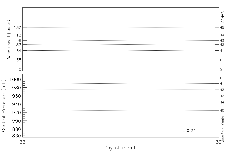
| Max Intensity |
25 kt (Oct 28 07Z) |
| End |
Oct 29 00Z |
| ATCF IDs |
SH041957 |
| Track status |
Best track data. |
|
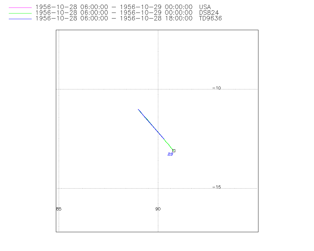
Storm track plot
|
Intensity plots
|
Radial wind information
No radial wind information for this storm
|
Position and Intensity Table
| BASIN |
ISO_TIME_________ |
NATURE |
LAT |
LON |
DS824 WIND |
| |
|
|
degrees north |
degrees east |
kts |
| SI |
1956-10-28 06:00:00 |
TS |
-11.00 |
89.00 |
25 |
| SI |
07:00:00 |
TS |
-11.13 |
89.12 |
25 |
| SI |
09:00:00 |
TS |
-11.40 |
89.35 |
25 |
| SI |
10:00:00 |
TS |
-11.53 |
89.47 |
25 |
| SI |
12:00:00 |
TS |
-11.79 |
89.70 |
25 |
| SI |
15:00:00 |
TS |
-12.16 |
90.01 |
25 |
| SI |
16:00:00 |
TS |
-12.28 |
90.11 |
25 |
| SI |
18:00:00 |
TS |
-12.50 |
90.30 |
25 |
| SI |
19:00:00 |
TS |
-12.61 |
90.39 |
25 |
| SI |
21:00:00 |
TS |
-12.82 |
90.56 |
25 |
| SI |
22:00:00 |
TS |
-12.92 |
90.64 |
25 |
| SI |
1956-10-29 00:00:00 |
TS |
-13.11 |
90.80 |
25 |
Source Information
| Agency |
Information |
| USA |
bsh041957.txt |
| TOKYO |
|
| CMA |
|
| HKO |
|
| NEWDELHI |
|
| REUNION |
|
| BOM |
|
| NADI |
|
| WELLINGTON |
|
| DS824 |
s_hem.dat:689:04S |
| TD9636 |
cons_worldwide_trop_cyclone_18710101-19891231-005:Line=7389 |
| TD9635 |
|
| NEUMANN |
|
| MLC |
|
All available IBTrACS Data
| SEASON |
BASIN |
SUBBASIN |
ISO_TIME_________ |
NATURE |
LAT |
LON |
DIST2LAND |
LANDFALL |
IFLAG |
USA AGENCY |
USA ATCF_ID |
USA LAT |
USA LON |
USA SSHS |
DS824 LAT |
DS824 LON |
DS824 STAGE |
DS824 WIND |
TD9636 LAT |
TD9636 LON |
TD9636 STAGE |
STORM SPEED |
STORM DIR |
| Year |
|
|
|
|
degrees north |
degrees east |
km |
km |
|
|
|
degrees north |
degrees east |
1 |
degrees north |
degrees east |
|
kts |
degrees north |
degrees east |
|
kts |
degrees |
| 1957 |
SI |
MM |
1956-10-28 06:00:00 |
TS |
-11.00 |
89.00 |
1510 |
1510 |
O________OO___ |
jtwc_sh |
SH041957 |
-11.00 |
89.00 |
-5 |
-11.00 |
89.00 |
TC |
25 |
-11.00 |
89.00 |
7 |
11 |
138 |
| 1957 |
SI |
MM |
07:00:00 |
TS |
-11.13 |
89.12 |
1510 |
1510 |
P________PP___ |
|
SH041957 |
-11.14 |
89.12 |
-5 |
-11.14 |
89.12 |
TC |
25 |
-11.13 |
89.11 |
7 |
11 |
139 |
| 1957 |
SI |
MM |
09:00:00 |
TS |
-11.40 |
89.35 |
1510 |
1510 |
P________PP___ |
|
SH041957 |
-11.41 |
89.36 |
-5 |
-11.41 |
89.36 |
TC |
25 |
-11.38 |
89.32 |
7 |
11 |
139 |
| 1957 |
SI |
MM |
10:00:00 |
TS |
-11.53 |
89.47 |
1510 |
1510 |
P________PP___ |
|
SH041957 |
-11.54 |
89.47 |
-5 |
-11.54 |
89.47 |
TC |
25 |
-11.50 |
89.43 |
7 |
10 |
139 |
| 1957 |
SI |
MM |
12:00:00 |
TS |
-11.79 |
89.70 |
1520 |
1520 |
O________OP___ |
jtwc_sh |
SH041957 |
-11.80 |
89.70 |
-5 |
-11.80 |
89.70 |
TC |
25 |
-11.75 |
89.65 |
7 |
10 |
140 |
| 1957 |
SI |
WA |
15:00:00 |
TS |
-12.16 |
90.01 |
1532 |
1525 |
P________PP___ |
|
SH041957 |
-12.16 |
90.02 |
-5 |
-12.16 |
90.02 |
TC |
25 |
-12.13 |
89.97 |
7 |
10 |
140 |
| 1957 |
SI |
WA |
16:00:00 |
TS |
-12.28 |
90.11 |
1533 |
1526 |
P________PP___ |
|
SH041957 |
-12.28 |
90.11 |
-5 |
-12.28 |
90.11 |
TC |
25 |
-12.25 |
90.08 |
7 |
9 |
141 |
| 1957 |
SI |
WA |
18:00:00 |
TS |
-12.50 |
90.30 |
1537 |
1537 |
O________OO___ |
jtwc_sh |
SH041957 |
-12.50 |
90.30 |
-5 |
-12.50 |
90.30 |
TC |
25 |
-12.50 |
90.30 |
1 |
9 |
141 |
| 1957 |
SI |
WA |
19:00:00 |
TS |
-12.61 |
90.39 |
1539 |
1539 |
P________P____ |
|
SH041957 |
-12.61 |
90.39 |
-5 |
-12.61 |
90.39 |
TC |
25 |
|
|
1 |
8 |
141 |
| 1957 |
SI |
WA |
21:00:00 |
TS |
-12.82 |
90.56 |
1543 |
1543 |
P________P____ |
|
SH041957 |
-12.81 |
90.56 |
-5 |
-12.81 |
90.56 |
TC |
25 |
|
|
1 |
8 |
142 |
| 1957 |
SI |
WA |
22:00:00 |
TS |
-12.92 |
90.64 |
1552 |
1546 |
P________P____ |
|
SH041957 |
-12.91 |
90.64 |
-5 |
-12.91 |
90.64 |
TC |
25 |
|
|
1 |
8 |
142 |
| 1957 |
SI |
WA |
1956-10-29 00:00:00 |
TS |
-13.11 |
90.80 |
1558 |
|
O________O____ |
jtwc_sh |
SH041957 |
-13.10 |
90.80 |
-5 |
-13.10 |
90.80 |
TC |
25 |
|
|
1 |
8 |
141 |