1955
Tropical Depression NOT_NAMED (1955190N19115)
IBTrACS version v04r00. Visit
IBTrACS website for data access.
Please direct all questions to the
IBTrACS Q and A forum
Storm track
-
Intensity
-
Wind Radii
-
Intensity Data
-
Source Data
-
All data
Summary Information
|
|
| Storm ID |
1955190N19115 |
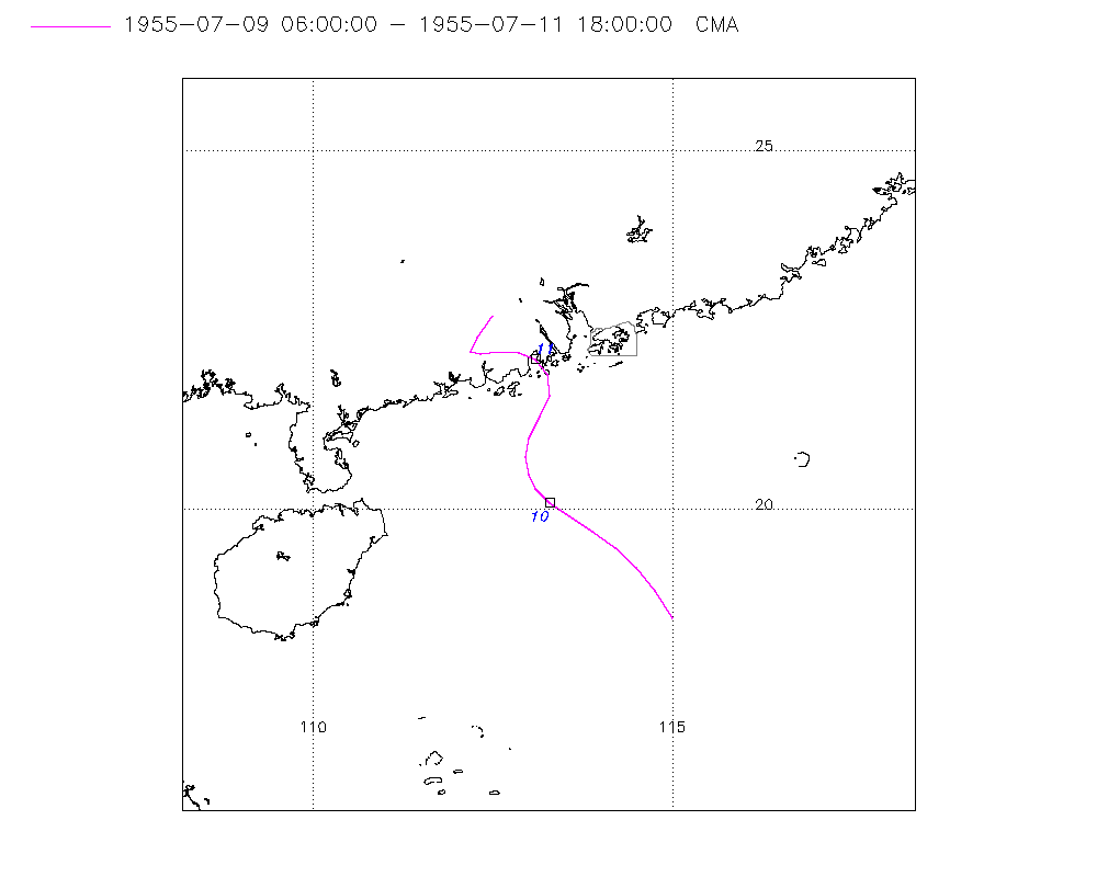
| Start |
Jul 9 06Z |
| Landfall |
Jul 11 00Z |
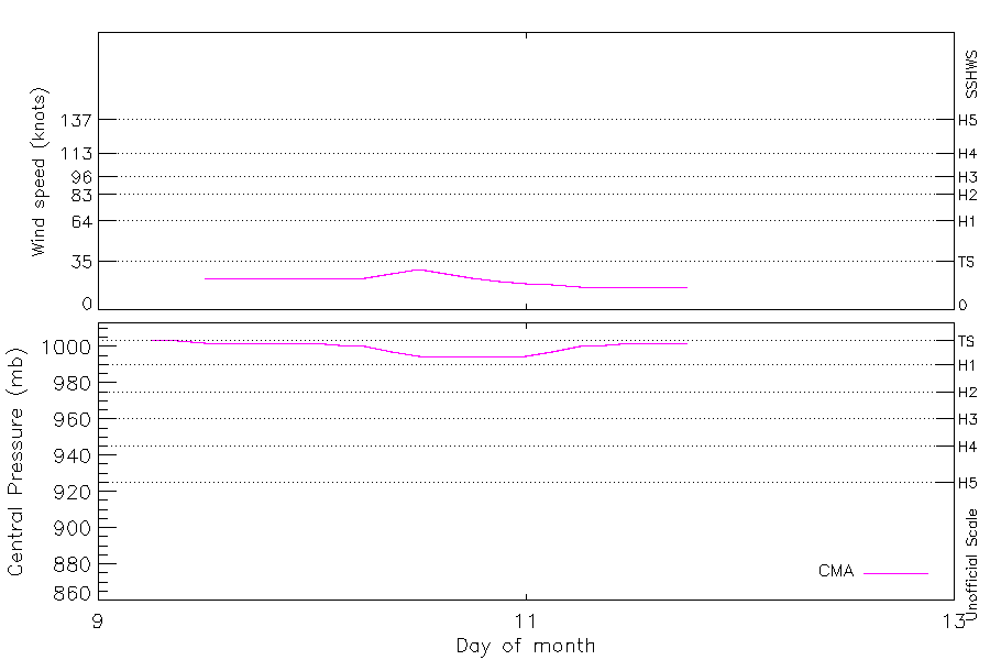
| Max Intensity |
29 kt (Jul 10 12Z), 995 mb (Jul 10 12Z) |
| End |
Jul 11 18Z |
| ATCF IDs |
|
| Track status |
Best track data. |
|
Storm track plot
|
Intensity plots
|
Radial wind information
No radial wind information for this storm
|
Position and Intensity Table
| BASIN |
ISO_TIME_________ |
NATURE |
LAT |
LON |
CMA WIND |
CMA PRES |
| |
|
|
degrees north |
degrees east |
kts |
mb |
| WP |
1955-07-09 06:00:00 |
TS |
18.50 |
115.00 |
|
1004 |
| WP |
09:00:00 |
TS |
18.87 |
114.76 |
|
1003 |
| WP |
12:00:00 |
TS |
19.20 |
114.50 |
23 |
1002 |
| WP |
15:00:00 |
TS |
19.47 |
114.21 |
23 |
1002 |
| WP |
18:00:00 |
TS |
19.70 |
113.90 |
23 |
1002 |
| WP |
21:00:00 |
TS |
19.91 |
113.58 |
23 |
1002 |
| WP |
1955-07-10 00:00:00 |
TS |
20.10 |
113.30 |
23 |
1002 |
| WP |
03:00:00 |
TS |
20.29 |
113.10 |
23 |
1001 |
| WP |
06:00:00 |
TS |
20.50 |
113.00 |
23 |
1000 |
| WP |
09:00:00 |
TS |
20.73 |
112.96 |
26 |
997 |
| WP |
12:00:00 |
TS |
21.00 |
113.00 |
29 |
995 |
| WP |
15:00:00 |
TS |
21.30 |
113.16 |
26 |
995 |
| WP |
18:00:00 |
TS |
21.60 |
113.30 |
23 |
995 |
| WP |
21:00:00 |
TS |
21.89 |
113.26 |
21 |
995 |
| WP |
1955-07-11 00:00:00 |
TS |
22.10 |
113.10 |
19 |
995 |
| WP |
03:00:00 |
TS |
22.19 |
112.86 |
18 |
997 |
| WP |
06:00:00 |
TS |
22.20 |
112.60 |
17 |
1000 |
| WP |
09:00:00 |
TS |
22.17 |
112.34 |
17 |
1001 |
| WP |
12:00:00 |
TS |
22.20 |
112.20 |
17 |
1002 |
| WP |
15:00:00 |
TS |
22.40 |
112.28 |
17 |
1002 |
| WP |
18:00:00 |
TS |
22.70 |
112.50 |
17 |
1002 |
Source Information
| Agency |
Information |
| USA |
|
| TOKYO |
|
| CMA |
CH1955BST.txt:Storm=8:(nameless) |
| HKO |
|
| NEWDELHI |
|
| REUNION |
|
| BOM |
|
| NADI |
|
| WELLINGTON |
|
| DS824 |
|
| TD9636 |
|
| TD9635 |
|
| NEUMANN |
|
| MLC |
|
All available IBTrACS Data
| SEASON |
BASIN |
SUBBASIN |
ISO_TIME_________ |
NATURE |
LAT |
LON |
DIST2LAND |
LANDFALL |
IFLAG |
USA SSHS |
CMA LAT |
CMA LON |
CMA CAT |
CMA WIND |
CMA PRES |
STORM SPEED |
STORM DIR |
| Year |
|
|
|
|
degrees north |
degrees east |
km |
km |
|
1 |
degrees north |
degrees east |
1 |
kts |
mb |
kts |
degrees |
| 1955 |
WP |
MM |
1955-07-09 06:00:00 |
TS |
18.50 |
115.00 |
431 |
394 |
__O___________ |
-5 |
18.50 |
115.00 |
0 |
|
1004 |
9 |
328 |
| 1955 |
WP |
MM |
09:00:00 |
TS |
18.87 |
114.76 |
383 |
339 |
__P___________ |
-5 |
18.87 |
114.76 |
0 |
|
1003 |
8 |
326 |
| 1955 |
WP |
MM |
12:00:00 |
TS |
19.20 |
114.50 |
339 |
295 |
__O___________ |
-5 |
19.20 |
114.50 |
1 |
23 |
1002 |
8 |
319 |
| 1955 |
WP |
MM |
15:00:00 |
TS |
19.47 |
114.21 |
295 |
263 |
__P___________ |
-5 |
19.47 |
114.21 |
1 |
23 |
1002 |
8 |
311 |
| 1955 |
WP |
MM |
18:00:00 |
TS |
19.70 |
113.90 |
263 |
232 |
__O___________ |
-5 |
19.70 |
113.90 |
1 |
23 |
1002 |
7 |
306 |
| 1955 |
WP |
MM |
21:00:00 |
TS |
19.91 |
113.58 |
232 |
203 |
__P___________ |
-5 |
19.91 |
113.58 |
1 |
23 |
1002 |
7 |
305 |
| 1955 |
WP |
MM |
1955-07-10 00:00:00 |
TS |
20.10 |
113.30 |
203 |
175 |
__O___________ |
-5 |
20.10 |
113.30 |
1 |
23 |
1002 |
6 |
311 |
| 1955 |
WP |
MM |
03:00:00 |
TS |
20.29 |
113.10 |
175 |
151 |
__P___________ |
-5 |
20.29 |
113.10 |
1 |
23 |
1001 |
5 |
325 |
| 1955 |
WP |
MM |
06:00:00 |
TS |
20.50 |
113.00 |
151 |
129 |
__O___________ |
-5 |
20.50 |
113.00 |
1 |
23 |
1000 |
5 |
342 |
| 1955 |
WP |
MM |
09:00:00 |
TS |
20.73 |
112.96 |
129 |
98 |
__P___________ |
-5 |
20.73 |
112.96 |
1 |
26 |
997 |
5 |
2 |
| 1955 |
WP |
MM |
12:00:00 |
TS |
21.00 |
113.00 |
98 |
67 |
__O___________ |
-5 |
21.00 |
113.00 |
1 |
29 |
995 |
6 |
19 |
| 1955 |
WP |
MM |
15:00:00 |
TS |
21.30 |
113.16 |
70 |
45 |
__P___________ |
-5 |
21.30 |
113.16 |
1 |
26 |
995 |
7 |
25 |
| 1955 |
WP |
MM |
18:00:00 |
TS |
21.60 |
113.30 |
45 |
22 |
__O___________ |
-5 |
21.60 |
113.30 |
1 |
23 |
995 |
6 |
8 |
| 1955 |
WP |
MM |
21:00:00 |
TS |
21.89 |
113.26 |
22 |
0 |
__P___________ |
-5 |
21.89 |
113.26 |
1 |
21 |
995 |
5 |
340 |
| 1955 |
WP |
MM |
1955-07-11 00:00:00 |
TS |
22.10 |
113.10 |
0 |
0 |
__O___________ |
-5 |
22.10 |
113.10 |
0 |
19 |
995 |
5 |
309 |
| 1955 |
WP |
MM |
03:00:00 |
TS |
22.19 |
112.86 |
0 |
0 |
__P___________ |
-5 |
22.19 |
112.86 |
0 |
18 |
997 |
5 |
282 |
| 1955 |
WP |
MM |
06:00:00 |
TS |
22.20 |
112.60 |
0 |
0 |
__O___________ |
-5 |
22.20 |
112.60 |
0 |
17 |
1000 |
5 |
268 |
| 1955 |
WP |
MM |
09:00:00 |
TS |
22.17 |
112.34 |
0 |
0 |
__P___________ |
-5 |
22.17 |
112.34 |
0 |
17 |
1001 |
4 |
270 |
| 1955 |
WP |
MM |
12:00:00 |
TS |
22.20 |
112.20 |
0 |
0 |
__O___________ |
-5 |
22.20 |
112.20 |
0 |
17 |
1002 |
2 |
346 |
| 1955 |
WP |
MM |
15:00:00 |
TS |
22.40 |
112.28 |
0 |
0 |
__P___________ |
-5 |
22.40 |
112.28 |
0 |
17 |
1002 |
6 |
29 |
| 1955 |
WP |
MM |
18:00:00 |
TS |
22.70 |
112.50 |
0 |
|
__O___________ |
-5 |
22.70 |
112.50 |
0 |
17 |
1002 |
7 |
33 |