1950
Severe Tropical Storm ELLEN (1950345N06172)
IBTrACS version v04r00. Visit
IBTrACS website for data access.
Please direct all questions to the
IBTrACS Q and A forum
Storm track
-
Intensity
-
Wind Radii
-
Intensity Data
-
Source Data
-
All data
Summary Information
|
|
| Storm ID |
1950345N06172 |
| Start |
Dec 11 06Z |
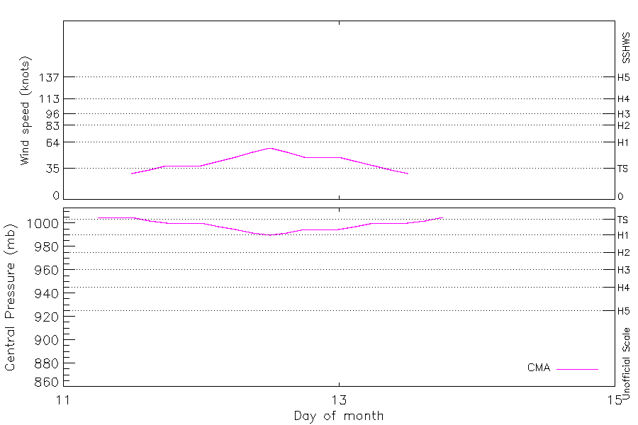
| Max Intensity |
58 kt (Dec 12 12Z), 990 mb (Dec 12 12Z) |
| End |
Dec 13 18Z |
| ATCF IDs |
|
| Track status |
Best track data. |
|
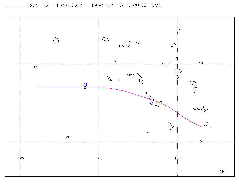
Storm track plot
|
Intensity plots
|
Radial wind information
No radial wind information for this storm
|
Position and Intensity Table
| BASIN |
ISO_TIME_________ |
NATURE |
LAT |
LON |
CMA WIND |
CMA PRES |
| |
|
|
degrees north |
degrees east |
kts |
mb |
| WP |
1950-12-11 06:00:00 |
TS |
6.00 |
171.50 |
|
1005 |
| WP |
09:00:00 |
TS |
6.28 |
170.94 |
|
1005 |
| WP |
12:00:00 |
TS |
6.60 |
170.40 |
29 |
1005 |
| WP |
15:00:00 |
TS |
6.96 |
169.89 |
33 |
1002 |
| WP |
18:00:00 |
TS |
7.30 |
169.40 |
38 |
1000 |
| WP |
21:00:00 |
TS |
7.52 |
168.91 |
38 |
1000 |
| WP |
1950-12-12 00:00:00 |
TS |
7.70 |
168.40 |
38 |
1000 |
| WP |
03:00:00 |
TS |
7.91 |
167.81 |
43 |
997 |
| WP |
06:00:00 |
TS |
8.10 |
167.20 |
48 |
995 |
| WP |
09:00:00 |
TS |
8.27 |
166.63 |
53 |
992 |
| WP |
12:00:00 |
TS |
8.40 |
166.10 |
58 |
990 |
| WP |
15:00:00 |
TS |
8.47 |
165.59 |
53 |
992 |
| WP |
18:00:00 |
TS |
8.50 |
165.10 |
48 |
995 |
| WP |
21:00:00 |
TS |
8.51 |
164.60 |
48 |
995 |
| WP |
1950-12-13 00:00:00 |
TS |
8.50 |
164.10 |
48 |
995 |
| WP |
03:00:00 |
TS |
8.50 |
163.60 |
43 |
997 |
| WP |
06:00:00 |
TS |
8.50 |
163.10 |
38 |
1000 |
| WP |
09:00:00 |
TS |
8.50 |
162.60 |
33 |
1000 |
| WP |
12:00:00 |
TS |
8.50 |
162.10 |
29 |
1000 |
| WP |
15:00:00 |
TS |
8.50 |
161.60 |
|
1002 |
| WP |
18:00:00 |
TS |
8.50 |
161.10 |
|
1005 |
Source Information
| Agency |
Information |
| USA |
|
| TOKYO |
|
| CMA |
CH1950BST.txt:Storm=41:Ellen |
| HKO |
|
| NEWDELHI |
|
| REUNION |
|
| BOM |
|
| NADI |
|
| WELLINGTON |
|
| DS824 |
|
| TD9636 |
|
| TD9635 |
|
| NEUMANN |
|
| MLC |
|
All available IBTrACS Data
| SEASON |
BASIN |
SUBBASIN |
ISO_TIME_________ |
NATURE |
LAT |
LON |
DIST2LAND |
LANDFALL |
IFLAG |
USA SSHS |
CMA LAT |
CMA LON |
CMA CAT |
CMA WIND |
CMA PRES |
STORM SPEED |
STORM DIR |
| Year |
|
|
|
|
degrees north |
degrees east |
km |
km |
|
1 |
degrees north |
degrees east |
1 |
kts |
mb |
kts |
degrees |
| 1950 |
WP |
MM |
1950-12-11 06:00:00 |
TS |
6.00 |
171.50 |
2003 |
1989 |
__O___________ |
-5 |
6.00 |
171.50 |
0 |
|
1005 |
13 |
297 |
| 1950 |
WP |
MM |
09:00:00 |
TS |
6.28 |
170.94 |
1992 |
1986 |
__P___________ |
-5 |
6.28 |
170.94 |
0 |
|
1005 |
13 |
299 |
| 1950 |
WP |
MM |
12:00:00 |
TS |
6.60 |
170.40 |
1990 |
1984 |
__O___________ |
-5 |
6.60 |
170.40 |
1 |
29 |
1005 |
12 |
303 |
| 1950 |
WP |
MM |
15:00:00 |
TS |
6.96 |
169.89 |
1999 |
1992 |
__P___________ |
-5 |
6.96 |
169.89 |
1 |
33 |
1002 |
12 |
305 |
| 1950 |
WP |
MM |
18:00:00 |
TS |
7.30 |
169.40 |
2001 |
1995 |
__O___________ |
-5 |
7.30 |
169.40 |
2 |
38 |
1000 |
11 |
300 |
| 1950 |
WP |
MM |
21:00:00 |
TS |
7.52 |
168.91 |
1995 |
1990 |
__P___________ |
-5 |
7.52 |
168.91 |
2 |
38 |
1000 |
11 |
292 |
| 1950 |
WP |
MM |
1950-12-12 00:00:00 |
TS |
7.70 |
168.40 |
1991 |
1983 |
__O___________ |
-5 |
7.70 |
168.40 |
2 |
38 |
1000 |
12 |
289 |
| 1950 |
WP |
MM |
03:00:00 |
TS |
7.91 |
167.81 |
1984 |
1978 |
__P___________ |
-5 |
7.91 |
167.81 |
2 |
43 |
997 |
13 |
289 |
| 1950 |
WP |
MM |
06:00:00 |
TS |
8.10 |
167.20 |
1980 |
1971 |
__O___________ |
-5 |
8.10 |
167.20 |
3 |
48 |
995 |
12 |
287 |
| 1950 |
WP |
MM |
09:00:00 |
TS |
8.27 |
166.63 |
1978 |
1971 |
__P___________ |
-5 |
8.27 |
166.63 |
3 |
53 |
992 |
11 |
285 |
| 1950 |
WP |
MM |
12:00:00 |
TS |
8.40 |
166.10 |
1971 |
1958 |
__O___________ |
-5 |
8.40 |
166.10 |
3 |
58 |
990 |
11 |
281 |
| 1950 |
WP |
MM |
15:00:00 |
TS |
8.47 |
165.59 |
1959 |
1930 |
__P___________ |
-5 |
8.47 |
165.59 |
3 |
53 |
992 |
10 |
276 |
| 1950 |
WP |
MM |
18:00:00 |
TS |
8.50 |
165.10 |
1930 |
1899 |
__O___________ |
-5 |
8.50 |
165.10 |
3 |
48 |
995 |
10 |
272 |
| 1950 |
WP |
MM |
21:00:00 |
TS |
8.51 |
164.60 |
1899 |
1869 |
__P___________ |
-5 |
8.51 |
164.60 |
3 |
48 |
995 |
10 |
270 |
| 1950 |
WP |
MM |
1950-12-13 00:00:00 |
TS |
8.50 |
164.10 |
1869 |
1835 |
__O___________ |
-5 |
8.50 |
164.10 |
3 |
48 |
995 |
10 |
270 |
| 1950 |
WP |
MM |
03:00:00 |
TS |
8.50 |
163.60 |
1835 |
1799 |
__P___________ |
-5 |
8.50 |
163.60 |
3 |
43 |
997 |
10 |
270 |
| 1950 |
WP |
MM |
06:00:00 |
TS |
8.50 |
163.10 |
1799 |
1764 |
__O___________ |
-5 |
8.50 |
163.10 |
2 |
38 |
1000 |
10 |
270 |
| 1950 |
WP |
MM |
09:00:00 |
TS |
8.50 |
162.60 |
1764 |
1731 |
__P___________ |
-5 |
8.50 |
162.60 |
2 |
33 |
1000 |
10 |
270 |
| 1950 |
WP |
MM |
12:00:00 |
TS |
8.50 |
162.10 |
1731 |
1698 |
__O___________ |
-5 |
8.50 |
162.10 |
1 |
29 |
1000 |
10 |
270 |
| 1950 |
WP |
MM |
15:00:00 |
TS |
8.50 |
161.60 |
1698 |
1663 |
__P___________ |
-5 |
8.50 |
161.60 |
1 |
|
1002 |
10 |
270 |
| 1950 |
WP |
MM |
18:00:00 |
TS |
8.50 |
161.10 |
1663 |
|
__O___________ |
-5 |
8.50 |
161.10 |
0 |
|
1005 |
10 |
270 |