1950
Severe Tropical Storm NOT_NAMED (1950222N25140)
IBTrACS version v04r00. Visit
IBTrACS website for data access.
Please direct all questions to the
IBTrACS Q and A forum
Storm track
-
Intensity
-
Wind Radii
-
Intensity Data
-
Source Data
-
All data
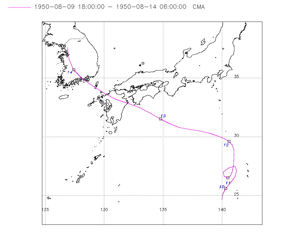
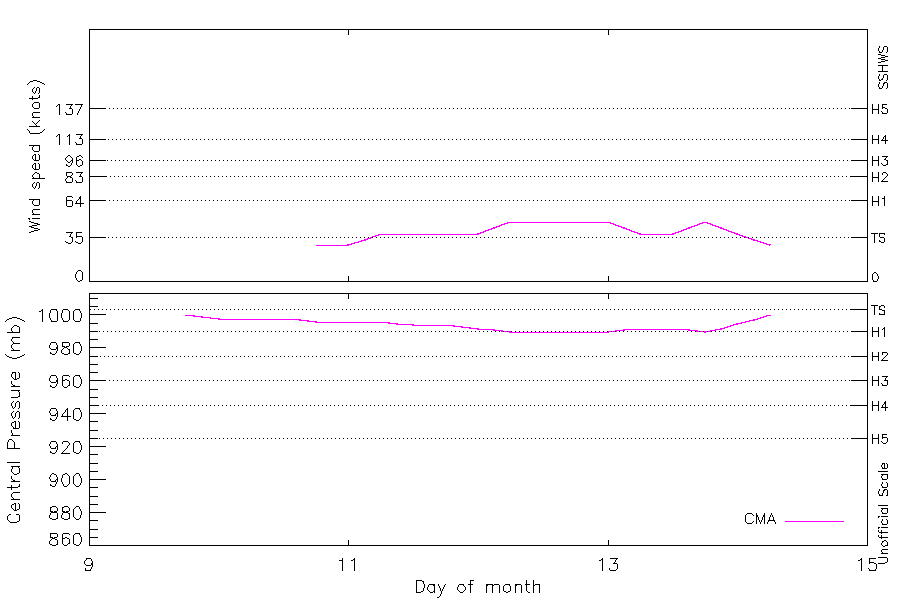
Summary Information
|
|
| Storm ID |
1950222N25140 |
| Start |
Aug 9 18Z |
| Landfall |
Aug 13 12Z, Aug 13 21Z |
| Max Intensity |
48 kt (Aug 12 06Z), 990 mb (Aug 12 06Z) |
| End |
Aug 14 06Z |
| ATCF IDs |
|
| Track status |
Best track data. |
|
Storm track plot
|
Intensity plots
|
Radial wind information
No radial wind information for this storm
|
Position and Intensity Table
| BASIN |
ISO_TIME_________ |
NATURE |
LAT |
LON |
CMA WIND |
CMA PRES |
| |
|
|
degrees north |
degrees east |
kts |
mb |
| WP |
1950-08-09 18:00:00 |
TS |
24.70 |
140.00 |
|
1000 |
| WP |
21:00:00 |
TS |
25.14 |
140.08 |
|
999 |
| WP |
1950-08-10 00:00:00 |
TS |
25.60 |
140.30 |
|
998 |
| WP |
03:00:00 |
TS |
26.10 |
140.72 |
|
998 |
| WP |
06:00:00 |
TS |
26.60 |
141.10 |
|
998 |
| WP |
09:00:00 |
TS |
27.16 |
141.24 |
|
998 |
| WP |
12:00:00 |
TS |
27.50 |
141.10 |
|
998 |
| WP |
15:00:00 |
TS |
27.36 |
140.57 |
|
997 |
| WP |
18:00:00 |
TS |
27.00 |
140.10 |
29 |
996 |
| WP |
21:00:00 |
TS |
26.67 |
140.20 |
29 |
996 |
| WP |
1950-08-11 00:00:00 |
TS |
26.50 |
140.50 |
29 |
996 |
| WP |
03:00:00 |
TS |
26.70 |
140.72 |
33 |
996 |
| WP |
06:00:00 |
TS |
27.10 |
140.90 |
38 |
996 |
| WP |
09:00:00 |
TS |
27.53 |
140.98 |
38 |
995 |
| WP |
12:00:00 |
TS |
28.00 |
141.00 |
38 |
994 |
| WP |
15:00:00 |
TS |
28.46 |
141.04 |
38 |
994 |
| WP |
18:00:00 |
TS |
28.90 |
141.00 |
38 |
994 |
| WP |
21:00:00 |
TS |
29.28 |
140.87 |
38 |
993 |
| WP |
1950-08-12 00:00:00 |
TS |
29.60 |
140.60 |
38 |
992 |
| WP |
03:00:00 |
TS |
29.87 |
140.18 |
43 |
991 |
| WP |
06:00:00 |
TS |
30.10 |
139.60 |
48 |
990 |
| WP |
09:00:00 |
TS |
30.31 |
138.90 |
48 |
990 |
| WP |
12:00:00 |
TS |
30.50 |
138.10 |
48 |
990 |
| WP |
15:00:00 |
TS |
30.63 |
137.26 |
48 |
990 |
| WP |
18:00:00 |
TS |
30.80 |
136.40 |
48 |
990 |
| WP |
21:00:00 |
TS |
31.10 |
135.61 |
48 |
990 |
| WP |
1950-08-13 00:00:00 |
TS |
31.50 |
134.80 |
48 |
990 |
| WP |
03:00:00 |
TS |
32.00 |
133.93 |
43 |
991 |
| WP |
06:00:00 |
TS |
32.50 |
133.00 |
38 |
992 |
| WP |
09:00:00 |
TS |
32.84 |
132.01 |
38 |
992 |
| WP |
12:00:00 |
TS |
33.20 |
131.00 |
38 |
992 |
| WP |
15:00:00 |
TS |
33.70 |
130.03 |
43 |
991 |
| WP |
18:00:00 |
TS |
34.30 |
129.10 |
48 |
990 |
| WP |
21:00:00 |
TS |
34.94 |
128.15 |
43 |
992 |
| WP |
1950-08-14 00:00:00 |
TS |
35.70 |
127.40 |
38 |
995 |
| WP |
03:00:00 |
TS |
36.61 |
127.03 |
33 |
997 |
| WP |
06:00:00 |
TS |
37.60 |
126.90 |
29 |
1000 |
Source Information
| Agency |
Information |
| USA |
|
| TOKYO |
|
| CMA |
CH1950BST.txt:Storm=20:(nameless) |
| HKO |
|
| NEWDELHI |
|
| REUNION |
|
| BOM |
|
| NADI |
|
| WELLINGTON |
|
| DS824 |
|
| TD9636 |
|
| TD9635 |
|
| NEUMANN |
|
| MLC |
|
All available IBTrACS Data
| SEASON |
BASIN |
SUBBASIN |
ISO_TIME_________ |
NATURE |
LAT |
LON |
DIST2LAND |
LANDFALL |
IFLAG |
USA SSHS |
CMA LAT |
CMA LON |
CMA CAT |
CMA WIND |
CMA PRES |
STORM SPEED |
STORM DIR |
| Year |
|
|
|
|
degrees north |
degrees east |
km |
km |
|
1 |
degrees north |
degrees east |
1 |
kts |
mb |
kts |
degrees |
| 1950 |
WP |
MM |
1950-08-09 18:00:00 |
TS |
24.70 |
140.00 |
1052 |
1015 |
__O___________ |
-5 |
24.70 |
140.00 |
0 |
|
1000 |
9 |
9 |
| 1950 |
WP |
MM |
21:00:00 |
TS |
25.14 |
140.08 |
1015 |
972 |
__P___________ |
-5 |
25.14 |
140.08 |
0 |
|
999 |
9 |
17 |
| 1950 |
WP |
MM |
1950-08-10 00:00:00 |
TS |
25.60 |
140.30 |
972 |
941 |
__O___________ |
-5 |
25.60 |
140.30 |
0 |
|
998 |
11 |
31 |
| 1950 |
WP |
MM |
03:00:00 |
TS |
26.10 |
140.72 |
941 |
913 |
__P___________ |
-5 |
26.10 |
140.72 |
0 |
|
998 |
12 |
36 |
| 1950 |
WP |
MM |
06:00:00 |
TS |
26.60 |
141.10 |
913 |
867 |
__O___________ |
-5 |
26.60 |
141.10 |
0 |
|
998 |
12 |
23 |
| 1950 |
WP |
MM |
09:00:00 |
TS |
27.16 |
141.24 |
856 |
821 |
__P___________ |
-5 |
27.16 |
141.24 |
0 |
|
998 |
9 |
0 |
| 1950 |
WP |
MM |
12:00:00 |
TS |
27.50 |
141.10 |
821 |
811 |
__O___________ |
-5 |
27.50 |
141.10 |
0 |
|
998 |
6 |
288 |
| 1950 |
WP |
MM |
15:00:00 |
TS |
27.36 |
140.57 |
811 |
810 |
__P___________ |
-5 |
27.36 |
140.57 |
0 |
|
997 |
10 |
241 |
| 1950 |
WP |
MM |
18:00:00 |
TS |
27.00 |
140.10 |
824 |
824 |
__O___________ |
-5 |
27.00 |
140.10 |
1 |
29 |
996 |
8 |
206 |
| 1950 |
WP |
MM |
21:00:00 |
TS |
26.67 |
140.20 |
858 |
858 |
__P___________ |
-5 |
26.67 |
140.20 |
1 |
29 |
996 |
6 |
144 |
| 1950 |
WP |
MM |
1950-08-11 00:00:00 |
TS |
26.50 |
140.50 |
892 |
883 |
__O___________ |
-5 |
26.50 |
140.50 |
1 |
29 |
996 |
5 |
87 |
| 1950 |
WP |
MM |
03:00:00 |
TS |
26.70 |
140.72 |
883 |
856 |
__P___________ |
-5 |
26.70 |
140.72 |
1 |
33 |
996 |
7 |
31 |
| 1950 |
WP |
MM |
06:00:00 |
TS |
27.10 |
140.90 |
856 |
819 |
__O___________ |
-5 |
27.10 |
140.90 |
2 |
38 |
996 |
9 |
16 |
| 1950 |
WP |
MM |
09:00:00 |
TS |
27.53 |
140.98 |
819 |
765 |
__P___________ |
-5 |
27.53 |
140.98 |
2 |
38 |
995 |
9 |
5 |
| 1950 |
WP |
MM |
12:00:00 |
TS |
28.00 |
141.00 |
765 |
722 |
__O___________ |
-5 |
28.00 |
141.00 |
2 |
38 |
994 |
9 |
3 |
| 1950 |
WP |
MM |
15:00:00 |
TS |
28.46 |
141.04 |
711 |
668 |
__P___________ |
-5 |
28.46 |
141.04 |
2 |
38 |
994 |
9 |
0 |
| 1950 |
WP |
MM |
18:00:00 |
TS |
28.90 |
141.00 |
668 |
623 |
__O___________ |
-5 |
28.90 |
141.00 |
2 |
38 |
994 |
8 |
350 |
| 1950 |
WP |
MM |
21:00:00 |
TS |
29.28 |
140.87 |
623 |
582 |
__P___________ |
-5 |
29.28 |
140.87 |
2 |
38 |
993 |
8 |
333 |
| 1950 |
WP |
MM |
1950-08-12 00:00:00 |
TS |
29.60 |
140.60 |
582 |
540 |
__O___________ |
-5 |
29.60 |
140.60 |
2 |
38 |
992 |
8 |
315 |
| 1950 |
WP |
MM |
03:00:00 |
TS |
29.87 |
140.18 |
540 |
507 |
__P___________ |
-5 |
29.87 |
140.18 |
2 |
43 |
991 |
10 |
300 |
| 1950 |
WP |
MM |
06:00:00 |
TS |
30.10 |
139.60 |
507 |
452 |
__O___________ |
-5 |
30.10 |
139.60 |
3 |
48 |
990 |
12 |
292 |
| 1950 |
WP |
MM |
09:00:00 |
TS |
30.31 |
138.90 |
452 |
389 |
__P___________ |
-5 |
30.31 |
138.90 |
3 |
48 |
990 |
14 |
287 |
| 1950 |
WP |
MM |
12:00:00 |
TS |
30.50 |
138.10 |
389 |
342 |
__O___________ |
-5 |
30.50 |
138.10 |
3 |
48 |
990 |
15 |
282 |
| 1950 |
WP |
MM |
15:00:00 |
TS |
30.63 |
137.26 |
342 |
295 |
__P___________ |
-5 |
30.63 |
137.26 |
3 |
48 |
990 |
15 |
282 |
| 1950 |
WP |
MM |
18:00:00 |
TS |
30.80 |
136.40 |
295 |
256 |
__O___________ |
-5 |
30.80 |
136.40 |
3 |
48 |
990 |
15 |
288 |
| 1950 |
WP |
MM |
21:00:00 |
TS |
31.10 |
135.61 |
257 |
197 |
__P___________ |
-5 |
31.10 |
135.61 |
3 |
48 |
990 |
15 |
297 |
| 1950 |
WP |
MM |
1950-08-13 00:00:00 |
TS |
31.50 |
134.80 |
197 |
122 |
__O___________ |
-5 |
31.50 |
134.80 |
3 |
48 |
990 |
17 |
302 |
| 1950 |
WP |
MM |
03:00:00 |
TS |
32.00 |
133.93 |
114 |
24 |
__P___________ |
-5 |
32.00 |
133.93 |
3 |
43 |
991 |
18 |
303 |
| 1950 |
WP |
MM |
06:00:00 |
TS |
32.50 |
133.00 |
22 |
11 |
__O___________ |
-5 |
32.50 |
133.00 |
2 |
38 |
992 |
18 |
297 |
| 1950 |
WP |
MM |
09:00:00 |
TS |
32.84 |
132.01 |
9 |
0 |
__P___________ |
-5 |
32.84 |
132.01 |
2 |
38 |
992 |
18 |
293 |
| 1950 |
WP |
MM |
12:00:00 |
TS |
33.20 |
131.00 |
0 |
0 |
__O___________ |
-5 |
33.20 |
131.00 |
2 |
38 |
992 |
19 |
297 |
| 1950 |
WP |
MM |
15:00:00 |
TS |
33.70 |
130.03 |
14 |
14 |
__P___________ |
-5 |
33.70 |
130.03 |
2 |
43 |
991 |
19 |
305 |
| 1950 |
WP |
MM |
18:00:00 |
TS |
34.30 |
129.10 |
78 |
0 |
__O___________ |
-5 |
34.30 |
129.10 |
3 |
48 |
990 |
20 |
309 |
| 1950 |
WP |
MM |
21:00:00 |
TS |
34.94 |
128.15 |
0 |
0 |
__P___________ |
-5 |
34.94 |
128.15 |
3 |
43 |
992 |
20 |
315 |
| 1950 |
WP |
MM |
1950-08-14 00:00:00 |
TS |
35.70 |
127.40 |
0 |
0 |
__O___________ |
-5 |
35.70 |
127.40 |
2 |
38 |
995 |
19 |
332 |
| 1950 |
WP |
MM |
03:00:00 |
TS |
36.61 |
127.03 |
0 |
0 |
__P___________ |
-5 |
36.61 |
127.03 |
2 |
33 |
997 |
19 |
348 |
| 1950 |
WP |
MM |
06:00:00 |
TS |
37.60 |
126.90 |
0 |
|
__O___________ |
-5 |
37.60 |
126.90 |
1 |
29 |
1000 |
20 |
354 |