1950
Tropical Depression NOT_NAMED (1950213N25128)
IBTrACS version v04r00. Visit
IBTrACS website for data access.
Please direct all questions to the
IBTrACS Q and A forum
Storm track
-
Intensity
-
Wind Radii
-
Intensity Data
-
Source Data
-
All data
Summary Information
|
|
| Storm ID |
1950213N25128 |
| Start |
Aug 1 06Z |
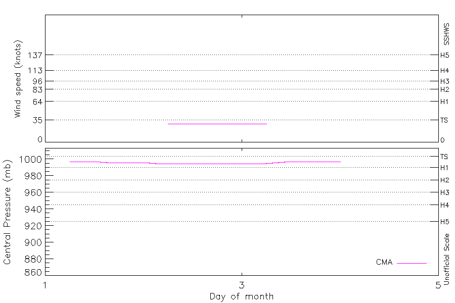
| Max Intensity |
29 kt (Aug 2 06Z), 995 mb (Aug 2 03Z) |
| End |
Aug 4 00Z |
| ATCF IDs |
|
| Track status |
Best track data. |
|
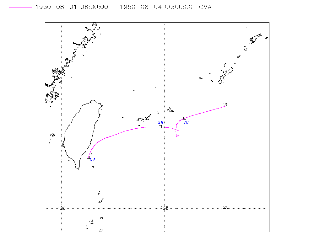
Storm track plot
|
Intensity plots
|
Radial wind information
No radial wind information for this storm
|
Position and Intensity Table
| BASIN |
ISO_TIME_________ |
NATURE |
LAT |
LON |
CMA WIND |
CMA PRES |
| |
|
|
degrees north |
degrees east |
kts |
mb |
| WP |
1950-08-01 06:00:00 |
TS |
25.00 |
128.00 |
|
997 |
| WP |
09:00:00 |
TS |
24.90 |
127.65 |
|
997 |
| WP |
12:00:00 |
TS |
24.80 |
127.30 |
|
997 |
| WP |
15:00:00 |
TS |
24.70 |
126.94 |
|
996 |
| WP |
18:00:00 |
TS |
24.60 |
126.60 |
|
996 |
| WP |
21:00:00 |
TS |
24.51 |
126.28 |
|
996 |
| WP |
1950-08-02 00:00:00 |
TS |
24.40 |
126.00 |
|
996 |
| WP |
03:00:00 |
TS |
24.28 |
125.75 |
|
995 |
| WP |
06:00:00 |
TS |
24.10 |
125.60 |
29 |
995 |
| WP |
09:00:00 |
TS |
23.75 |
125.56 |
29 |
995 |
| WP |
12:00:00 |
TS |
23.50 |
125.60 |
29 |
995 |
| WP |
15:00:00 |
TS |
23.59 |
125.72 |
29 |
995 |
| WP |
18:00:00 |
TS |
23.80 |
125.70 |
29 |
995 |
| WP |
21:00:00 |
TS |
23.93 |
125.35 |
29 |
995 |
| WP |
1950-08-03 00:00:00 |
TS |
24.00 |
124.80 |
29 |
995 |
| WP |
03:00:00 |
TS |
23.99 |
124.21 |
29 |
995 |
| WP |
06:00:00 |
TS |
23.90 |
123.60 |
29 |
995 |
| WP |
09:00:00 |
TS |
23.77 |
123.08 |
|
996 |
| WP |
12:00:00 |
TS |
23.60 |
122.60 |
|
997 |
| WP |
15:00:00 |
TS |
23.43 |
122.11 |
|
997 |
| WP |
18:00:00 |
TS |
23.20 |
121.70 |
|
997 |
| WP |
21:00:00 |
TS |
22.88 |
121.45 |
|
997 |
| WP |
1950-08-04 00:00:00 |
TS |
22.50 |
121.30 |
|
997 |
Source Information
| Agency |
Information |
| USA |
|
| TOKYO |
|
| CMA |
CH1950BST.txt:Storm=14:(nameless) |
| HKO |
|
| NEWDELHI |
|
| REUNION |
|
| BOM |
|
| NADI |
|
| WELLINGTON |
|
| DS824 |
|
| TD9636 |
|
| TD9635 |
|
| NEUMANN |
|
| MLC |
|
All available IBTrACS Data
| SEASON |
BASIN |
SUBBASIN |
ISO_TIME_________ |
NATURE |
LAT |
LON |
DIST2LAND |
LANDFALL |
IFLAG |
USA SSHS |
CMA LAT |
CMA LON |
CMA CAT |
CMA WIND |
CMA PRES |
STORM SPEED |
STORM DIR |
| Year |
|
|
|
|
degrees north |
degrees east |
km |
km |
|
1 |
degrees north |
degrees east |
1 |
kts |
mb |
kts |
degrees |
| 1950 |
WP |
MM |
1950-08-01 06:00:00 |
TS |
25.00 |
128.00 |
604 |
574 |
__O___________ |
-5 |
25.00 |
128.00 |
0 |
|
997 |
7 |
252 |
| 1950 |
WP |
MM |
09:00:00 |
TS |
24.90 |
127.65 |
574 |
534 |
__P___________ |
-5 |
24.90 |
127.65 |
0 |
|
997 |
7 |
253 |
| 1950 |
WP |
MM |
12:00:00 |
TS |
24.80 |
127.30 |
534 |
505 |
__O___________ |
-5 |
24.80 |
127.30 |
0 |
|
997 |
7 |
253 |
| 1950 |
WP |
MM |
15:00:00 |
TS |
24.70 |
126.94 |
495 |
466 |
__P___________ |
-5 |
24.70 |
126.94 |
0 |
|
996 |
7 |
253 |
| 1950 |
WP |
MM |
18:00:00 |
TS |
24.60 |
126.60 |
466 |
437 |
__O___________ |
-5 |
24.60 |
126.60 |
0 |
|
996 |
6 |
252 |
| 1950 |
WP |
MM |
21:00:00 |
TS |
24.51 |
126.28 |
437 |
409 |
__P___________ |
-5 |
24.51 |
126.28 |
0 |
|
996 |
6 |
250 |
| 1950 |
WP |
MM |
1950-08-02 00:00:00 |
TS |
24.40 |
126.00 |
409 |
391 |
__O___________ |
-5 |
24.40 |
126.00 |
0 |
|
996 |
5 |
244 |
| 1950 |
WP |
MM |
03:00:00 |
TS |
24.28 |
125.75 |
391 |
374 |
__P___________ |
-5 |
24.28 |
125.75 |
0 |
|
995 |
5 |
230 |
| 1950 |
WP |
MM |
06:00:00 |
TS |
24.10 |
125.60 |
377 |
377 |
__O___________ |
-5 |
24.10 |
125.60 |
1 |
29 |
995 |
6 |
199 |
| 1950 |
WP |
MM |
09:00:00 |
TS |
23.75 |
125.56 |
383 |
383 |
__P___________ |
-5 |
23.75 |
125.56 |
1 |
29 |
995 |
6 |
179 |
| 1950 |
WP |
MM |
12:00:00 |
TS |
23.50 |
125.60 |
391 |
391 |
__O___________ |
-5 |
23.50 |
125.60 |
1 |
29 |
995 |
2 |
140 |
| 1950 |
WP |
MM |
15:00:00 |
TS |
23.59 |
125.72 |
398 |
393 |
__P___________ |
-5 |
23.59 |
125.72 |
1 |
29 |
995 |
3 |
16 |
| 1950 |
WP |
MM |
18:00:00 |
TS |
23.80 |
125.70 |
393 |
361 |
__O___________ |
-5 |
23.80 |
125.70 |
1 |
29 |
995 |
5 |
315 |
| 1950 |
WP |
MM |
21:00:00 |
TS |
23.93 |
125.35 |
351 |
299 |
__P___________ |
-5 |
23.93 |
125.35 |
1 |
29 |
995 |
8 |
284 |
| 1950 |
WP |
MM |
1950-08-03 00:00:00 |
TS |
24.00 |
124.80 |
299 |
239 |
__O___________ |
-5 |
24.00 |
124.80 |
1 |
29 |
995 |
10 |
273 |
| 1950 |
WP |
MM |
03:00:00 |
TS |
23.99 |
124.21 |
239 |
184 |
__P___________ |
-5 |
23.99 |
124.21 |
1 |
29 |
995 |
11 |
265 |
| 1950 |
WP |
MM |
06:00:00 |
TS |
23.90 |
123.60 |
184 |
144 |
__O___________ |
-5 |
23.90 |
123.60 |
1 |
29 |
995 |
11 |
258 |
| 1950 |
WP |
MM |
09:00:00 |
TS |
23.77 |
123.08 |
144 |
112 |
__P___________ |
-5 |
23.77 |
123.08 |
1 |
|
996 |
10 |
252 |
| 1950 |
WP |
MM |
12:00:00 |
TS |
23.60 |
122.60 |
112 |
69 |
__O___________ |
-5 |
23.60 |
122.60 |
0 |
|
997 |
10 |
249 |
| 1950 |
WP |
MM |
15:00:00 |
TS |
23.43 |
122.11 |
69 |
30 |
__P___________ |
-5 |
23.43 |
122.11 |
0 |
|
997 |
9 |
244 |
| 1950 |
WP |
MM |
18:00:00 |
TS |
23.20 |
121.70 |
30 |
15 |
__O___________ |
-5 |
23.20 |
121.70 |
0 |
|
997 |
8 |
227 |
| 1950 |
WP |
MM |
21:00:00 |
TS |
22.88 |
121.45 |
23 |
15 |
__P___________ |
-5 |
22.88 |
121.45 |
0 |
|
997 |
8 |
208 |
| 1950 |
WP |
MM |
1950-08-04 00:00:00 |
TS |
22.50 |
121.30 |
32 |
|
__O___________ |
-5 |
22.50 |
121.30 |
0 |
|
997 |
8 |
201 |