1947
Typhoon HANNAH (1947326N24136)
IBTrACS version v04r00. Visit
IBTrACS website for data access.
Please direct all questions to the
IBTrACS Q and A forum
Storm track
-
Intensity
-
Wind Radii
-
Intensity Data
-
Source Data
-
All data
Summary Information
|
|
| Storm ID |
1947326N24136 |
| Start |
Nov 22 06Z |
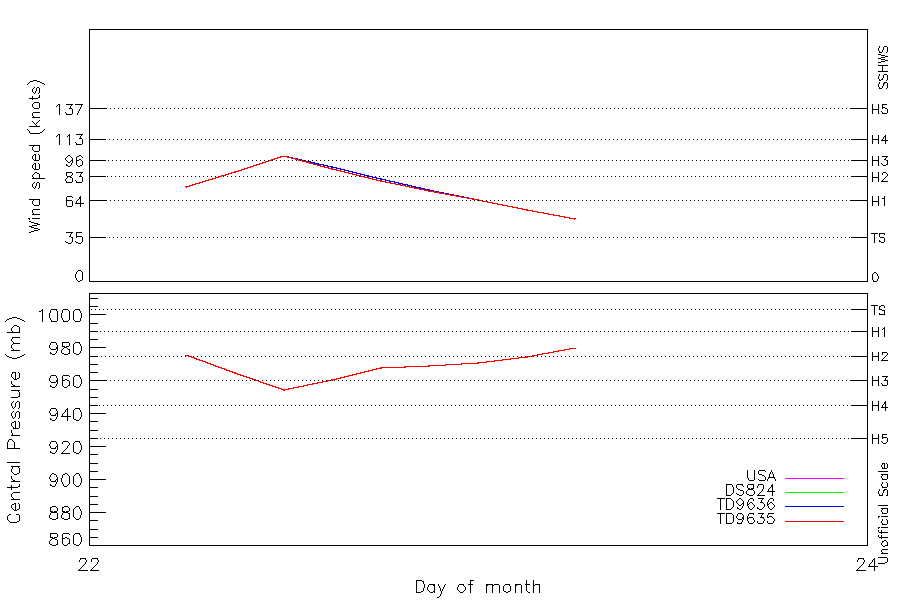
| Max Intensity |
100 kt (Nov 22 12Z), 955 mb (Nov 22 12Z) |
| End |
Nov 23 06Z |
| ATCF IDs |
WP251947 |
| Track status |
Best track data. |
|
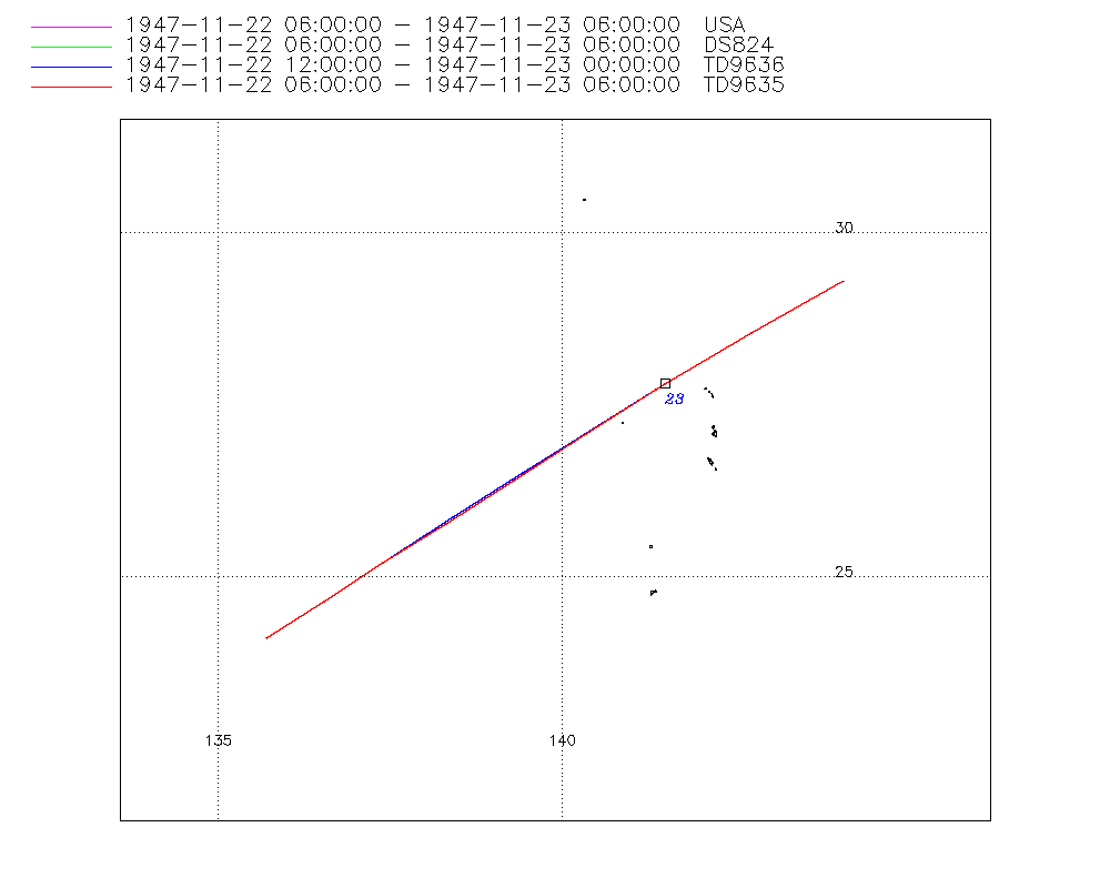
Storm track plot
|
Intensity plots
|
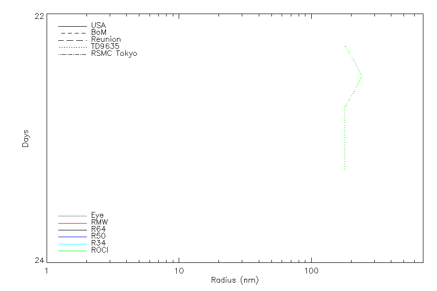
Radial wind information
|
Position and Intensity Table
| BASIN |
ISO_TIME_________ |
NATURE |
LAT |
LON |
USA WIND |
DS824 WIND |
TD9636 WIND |
TD9635 WIND |
TD9635 PRES |
| |
|
|
degrees north |
degrees east |
kts |
kts |
kts |
kts |
mb |
| WP |
1947-11-22 06:00:00 |
TS |
24.10 |
135.70 |
75 |
75 |
|
75 |
976 |
| WP |
09:00:00 |
TS |
24.65 |
136.54 |
87 |
87 |
|
87 |
965 |
| WP |
12:00:00 |
TS |
25.20 |
137.40 |
100 |
100 |
100 |
100 |
955 |
| WP |
15:00:00 |
TS |
25.79 |
138.33 |
90 |
90 |
91 |
90 |
961 |
| WP |
18:00:00 |
TS |
26.42 |
139.33 |
80 |
80 |
82 |
80 |
968 |
| WP |
21:00:00 |
TS |
27.09 |
140.36 |
72 |
72 |
73 |
72 |
969 |
| WP |
1947-11-23 00:00:00 |
TS |
27.80 |
141.50 |
65 |
65 |
65 |
65 |
971 |
| WP |
03:00:00 |
TS |
28.55 |
142.76 |
57 |
57 |
|
57 |
975 |
| WP |
06:00:00 |
TS |
29.30 |
144.10 |
50 |
50 |
|
50 |
980 |
Source Information
| Agency |
Information |
| USA |
bwp251947.txt |
| TOKYO |
|
| CMA |
|
| HKO |
|
| NEWDELHI |
|
| REUNION |
|
| BOM |
|
| NADI |
|
| WELLINGTON |
|
| DS824 |
w_npac.dat:66:25W |
| TD9636 |
cons_worldwide_trop_cyclone_18710101-19891231-003:Line=14626 |
| TD9635 |
typhoons-analogs_19450101-19761231.corrected:Line=12750 |
| NEUMANN |
|
| MLC |
|
All available IBTrACS Data
| SEASON |
BASIN |
SUBBASIN |
ISO_TIME_________ |
NATURE |
LAT |
LON |
DIST2LAND |
LANDFALL |
IFLAG |
USA AGENCY |
USA ATCF_ID |
USA LAT |
USA LON |
USA WIND |
USA SSHS |
DS824 LAT |
DS824 LON |
DS824 STAGE |
DS824 WIND |
TD9636 LAT |
TD9636 LON |
TD9636 STAGE |
TD9636 WIND |
TD9635 LAT |
TD9635 LON |
TD9635 WIND |
TD9635 PRES |
TD9635 ROCI |
STORM SPEED |
STORM DIR |
| Year |
|
|
|
|
degrees north |
degrees east |
km |
km |
|
|
|
degrees north |
degrees east |
kts |
1 |
degrees north |
degrees east |
|
kts |
degrees north |
degrees east |
|
kts |
degrees north |
degrees east |
kts |
mb |
nmile |
kts |
degrees |
| 1947 |
WP |
MM |
1947-11-22 06:00:00 |
TS |
24.10 |
135.70 |
914 |
903 |
O________O_O__ |
jtwc_wp |
WP251947 |
24.10 |
135.70 |
75 |
1 |
24.10 |
135.70 |
TC |
75 |
|
|
|
|
24.10 |
135.70 |
75 |
976 |
180 |
19 |
54 |
| 1947 |
WP |
MM |
09:00:00 |
TS |
24.65 |
136.54 |
908 |
900 |
P________P_P__ |
|
WP251947 |
24.65 |
136.54 |
87 |
2 |
24.65 |
136.54 |
TC |
87 |
|
|
|
|
24.65 |
136.54 |
87 |
965 |
210 |
19 |
55 |
| 1947 |
WP |
MM |
12:00:00 |
TS |
25.20 |
137.40 |
907 |
881 |
O________OOO__ |
jtwc_wp |
WP251947 |
25.20 |
137.40 |
100 |
3 |
25.20 |
137.40 |
TC |
100 |
25.20 |
137.40 |
3 |
100 |
25.20 |
137.40 |
100 |
955 |
240 |
20 |
55 |
| 1947 |
WP |
MM |
15:00:00 |
TS |
25.79 |
138.33 |
881 |
846 |
P________PPP__ |
|
WP251947 |
25.78 |
138.31 |
90 |
2 |
25.78 |
138.31 |
TC |
90 |
25.86 |
138.41 |
3 |
91 |
25.78 |
138.31 |
90 |
961 |
210 |
21 |
55 |
| 1947 |
WP |
MM |
18:00:00 |
TS |
26.42 |
139.33 |
850 |
824 |
O________OPO__ |
jtwc_wp |
WP251947 |
26.40 |
139.30 |
80 |
1 |
26.40 |
139.30 |
TC |
80 |
26.51 |
139.43 |
3 |
82 |
26.40 |
139.30 |
80 |
968 |
180 |
22 |
55 |
| 1947 |
WP |
MM |
21:00:00 |
TS |
27.09 |
140.36 |
829 |
797 |
P________PPP__ |
|
WP251947 |
27.08 |
140.35 |
72 |
1 |
27.08 |
140.35 |
TC |
72 |
27.16 |
140.46 |
3 |
73 |
27.08 |
140.35 |
72 |
969 |
180 |
24 |
55 |
| 1947 |
WP |
MM |
1947-11-23 00:00:00 |
TS |
27.80 |
141.50 |
800 |
757 |
O________OOO__ |
jtwc_wp |
WP251947 |
27.80 |
141.50 |
65 |
1 |
27.80 |
141.50 |
TC |
65 |
27.80 |
141.50 |
4 |
65 |
27.80 |
141.50 |
65 |
971 |
180 |
26 |
55 |
| 1947 |
WP |
MM |
03:00:00 |
TS |
28.55 |
142.76 |
764 |
733 |
P________P_P__ |
|
WP251947 |
28.55 |
142.76 |
57 |
0 |
28.55 |
142.76 |
TC |
57 |
|
|
4 |
|
28.55 |
142.76 |
57 |
975 |
180 |
27 |
57 |
| 1947 |
WP |
MM |
06:00:00 |
TS |
29.30 |
144.10 |
738 |
|
O________O_O__ |
jtwc_wp |
WP251947 |
29.30 |
144.10 |
50 |
0 |
29.30 |
144.10 |
TC |
50 |
|
|
4 |
|
29.30 |
144.10 |
50 |
980 |
180 |
28 |
57 |