1945
Tropical Low NOT_NAMED (1945083S19114)
IBTrACS version v04r00. Visit
IBTrACS website for data access.
Please direct all questions to the
IBTrACS Q and A forum
Storm track
-
Intensity
-
Wind Radii
-
Intensity Data
-
Source Data
-
All data
Summary Information
|
|
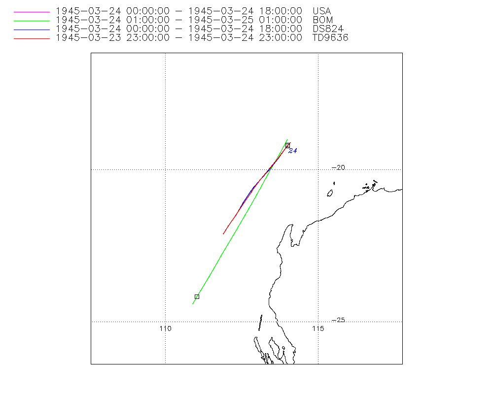
| Storm ID |
1945083S19114 |
| Start |
Mar 23 23Z |
| Max Intensity |
995 mb (Mar 24 01Z) |
| End |
Mar 25 01Z |
| ATCF IDs |
,SH111945 |
| Track status |
Best track data. |
|
Storm track plot
|
Intensity plots
|
Radial wind information
No radial wind information for this storm
|
Position and Intensity Table
| BASIN |
ISO_TIME_________ |
NATURE |
LAT |
LON |
WMO PRES |
BOM PRES |
| |
|
|
degrees north |
degrees east |
mb |
mb |
| SI |
1945-03-23 23:00:00 |
NR |
-19.10 |
114.10 |
|
|
| SI |
1945-03-24 00:00:00 |
TS |
-19.21 |
114.00 |
|
|
| SI |
01:00:00 |
TS |
-19.30 |
113.91 |
995 |
995 |
| SI |
03:00:00 |
TS |
-19.58 |
113.71 |
|
|
| SI |
06:00:00 |
TS |
-20.02 |
113.40 |
|
|
| SI |
09:00:00 |
TS |
-20.46 |
113.07 |
|
|
| SI |
11:00:00 |
TS |
-20.75 |
112.86 |
|
|
| SI |
12:00:00 |
TS |
-20.93 |
112.75 |
|
|
| SI |
15:00:00 |
TS |
-21.45 |
112.44 |
|
|
| SI |
18:00:00 |
TS |
-22.08 |
112.10 |
|
|
| SI |
21:00:00 |
NR |
-22.95 |
111.64 |
|
|
| SI |
23:00:00 |
NR |
-23.49 |
111.35 |
|
|
| SI |
1945-03-25 00:00:00 |
TS |
-24.18 |
111.02 |
|
|
| SI |
01:00:00 |
NR |
-24.40 |
110.90 |
1002 |
1002 |
Source Information
| Agency |
Information |
| USA |
bsh111945.txt |
| TOKYO |
|
| CMA |
|
| HKO |
|
| NEWDELHI |
|
| REUNION |
|
| BOM |
IDCKMSTM0S.csv:Line=1260:unnamed |
| NADI |
|
| WELLINGTON |
|
| DS824 |
s_hem.dat:424:11S |
| TD9636 |
cons_worldwide_trop_cyclone_18710101-19891231-006:Line=2870 |
| TD9635 |
|
| NEUMANN |
|
| MLC |
|
All available IBTrACS Data
| SEASON |
BASIN |
SUBBASIN |
ISO_TIME_________ |
NATURE |
LAT |
LON |
WMO PRES |
WMO AGENCY |
DIST2LAND |
LANDFALL |
IFLAG |
USA AGENCY |
USA ATCF_ID |
USA LAT |
USA LON |
USA SSHS |
BOM LAT |
BOM LON |
BOM PRES |
BOM PRES_METHOD |
DS824 LAT |
DS824 LON |
DS824 STAGE |
TD9636 LAT |
TD9636 LON |
TD9636 STAGE |
STORM SPEED |
STORM DIR |
| Year |
|
|
|
|
degrees north |
degrees east |
mb |
|
km |
km |
|
|
|
degrees north |
degrees east |
1 |
degrees north |
degrees east |
mb |
|
degrees north |
degrees east |
|
degrees north |
degrees east |
|
kts |
degrees |
| 1945 |
SI |
WA |
1945-03-23 23:00:00 |
NR |
-19.10 |
114.10 |
|
|
292 |
290 |
__________O___ |
|
|
|
|
-5 |
|
|
|
|
|
|
|
-19.10 |
114.10 |
7 |
9 |
220 |
| 1945 |
SI |
WA |
1945-03-24 00:00:00 |
TS |
-19.21 |
114.00 |
|
|
290 |
282 |
O________OP___ |
jtwc_sh |
SH111945 |
-19.20 |
114.00 |
-5 |
|
|
|
|
-19.20 |
114.00 |
TC |
-19.23 |
114.00 |
7 |
8 |
222 |
| 1945 |
SI |
WA |
01:00:00 |
TS |
-19.30 |
113.91 |
995 |
bom |
287 |
259 |
P_____O__PP___ |
|
SH111945 |
-19.34 |
113.90 |
-5 |
-19.00 |
114.00 |
995 |
4 |
-19.34 |
113.90 |
TC |
-19.35 |
113.90 |
7 |
9 |
217 |
| 1945 |
SI |
WA |
03:00:00 |
TS |
-19.58 |
113.71 |
|
|
259 |
221 |
P_____P__PP___ |
|
SH111945 |
-19.61 |
113.70 |
-5 |
-19.45 |
113.75 |
|
|
-19.61 |
113.70 |
TC |
-19.60 |
113.70 |
7 |
10 |
214 |
| 1945 |
SI |
WA |
06:00:00 |
TS |
-20.02 |
113.40 |
|
|
221 |
191 |
O_____P__OP___ |
jtwc_sh |
SH111945 |
-20.00 |
113.40 |
-5 |
-20.13 |
113.37 |
|
|
-20.00 |
113.40 |
TC |
-19.98 |
113.40 |
7 |
11 |
214 |
| 1945 |
SI |
WA |
09:00:00 |
TS |
-20.46 |
113.07 |
|
|
182 |
176 |
P_____P__PP___ |
|
SH111945 |
-20.35 |
113.09 |
-5 |
-20.81 |
112.99 |
|
|
-20.35 |
113.09 |
TC |
-20.35 |
113.10 |
7 |
11 |
214 |
| 1945 |
SI |
WA |
11:00:00 |
TS |
-20.75 |
112.86 |
|
|
167 |
167 |
P_____P__PO___ |
|
SH111945 |
-20.58 |
112.89 |
-5 |
-21.26 |
112.74 |
|
|
-20.58 |
112.89 |
TC |
-20.60 |
112.90 |
7 |
11 |
213 |
| 1945 |
SI |
WA |
12:00:00 |
TS |
-20.93 |
112.75 |
|
|
167 |
161 |
O_____P__OP___ |
jtwc_sh |
SH111945 |
-20.70 |
112.80 |
-5 |
-21.48 |
112.61 |
|
|
-20.70 |
112.80 |
TC |
-20.73 |
112.82 |
7 |
12 |
209 |
| 1945 |
SI |
WA |
15:00:00 |
TS |
-21.45 |
112.44 |
|
|
173 |
158 |
P_____P__PP___ |
|
SH111945 |
-21.09 |
112.54 |
-5 |
-22.16 |
112.22 |
|
|
-21.09 |
112.54 |
TC |
-21.10 |
112.57 |
7 |
13 |
208 |
| 1945 |
SI |
WA |
18:00:00 |
TS |
-22.08 |
112.10 |
|
|
164 |
160 |
O_____P__OP___ |
jtwc_sh |
SH111945 |
-21.50 |
112.30 |
-5 |
-22.83 |
111.83 |
|
|
-21.50 |
112.30 |
TC |
-21.48 |
112.32 |
7 |
17 |
206 |
| 1945 |
SI |
WA |
21:00:00 |
NR |
-22.95 |
111.64 |
|
|
209 |
209 |
______P___P___ |
|
SH111945 |
|
|
-5 |
-23.51 |
111.43 |
|
|
|
|
TC |
-21.85 |
112.07 |
7 |
19 |
206 |
| 1945 |
SI |
WA |
23:00:00 |
NR |
-23.49 |
111.35 |
|
|
218 |
218 |
______P___O___ |
|
SH111945 |
|
|
-5 |
-23.95 |
111.17 |
|
|
|
|
TC |
-22.10 |
111.90 |
7 |
27 |
205 |
| 1945 |
SI |
WA |
1945-03-25 00:00:00 |
TS |
-24.18 |
111.02 |
|
|
244 |
243 |
______P_______ |
|
|
|
|
-5 |
-24.18 |
111.03 |
|
|
|
|
|
|
|
7 |
30 |
204 |
| 1945 |
SI |
WA |
01:00:00 |
NR |
-24.40 |
110.90 |
1002 |
bom |
253 |
|
______O_______ |
|
|
|
|
-5 |
-24.40 |
110.90 |
1002 |
|
|
|
|
|
|
7 |
15 |
208 |