2004
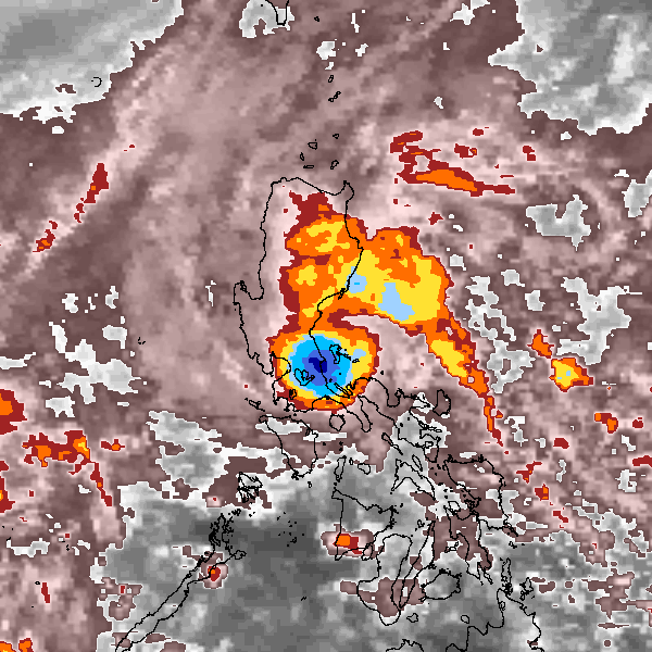
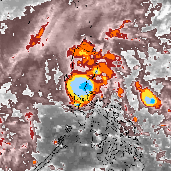
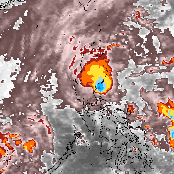
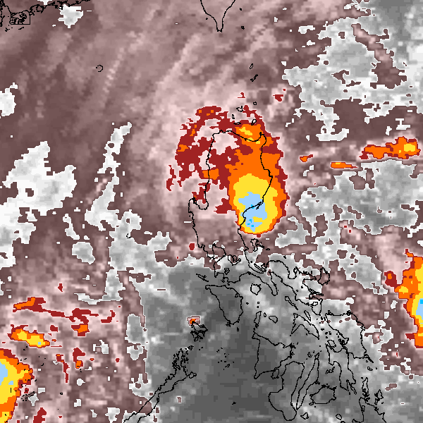
Tropical Storm MERBOK (2004327N16125)
IBTrACS version v04r00. Visit
IBTrACS website for data access.
Please direct all questions to the
IBTrACS Q and A forum
Storm track
-
Intensity
-
Wind Radii
-
Intensity Data
-
Source Data
-
All data
Summary Information
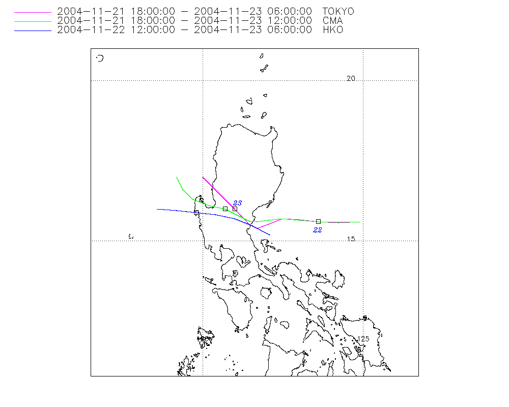
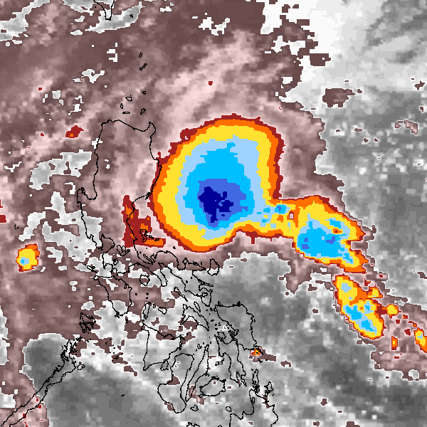
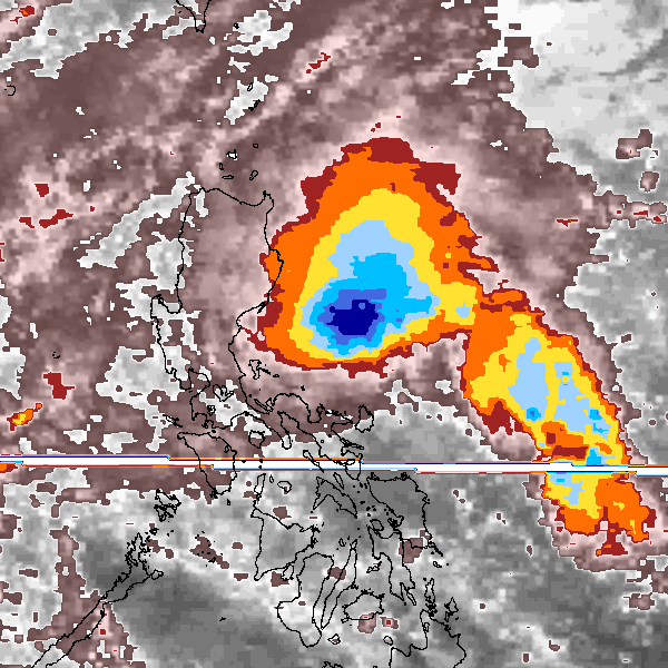
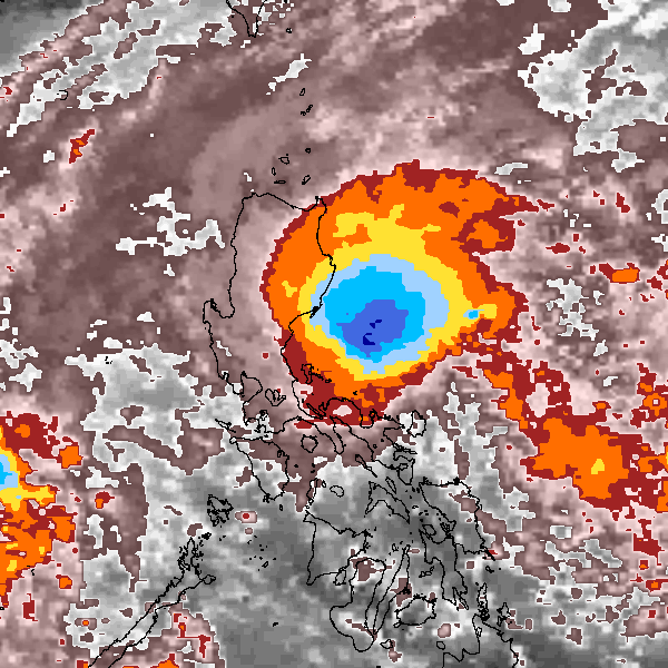
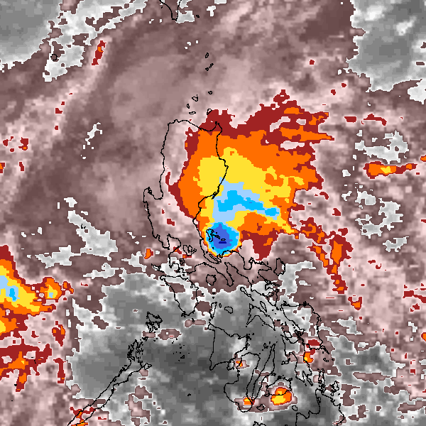
Storm track plot
|
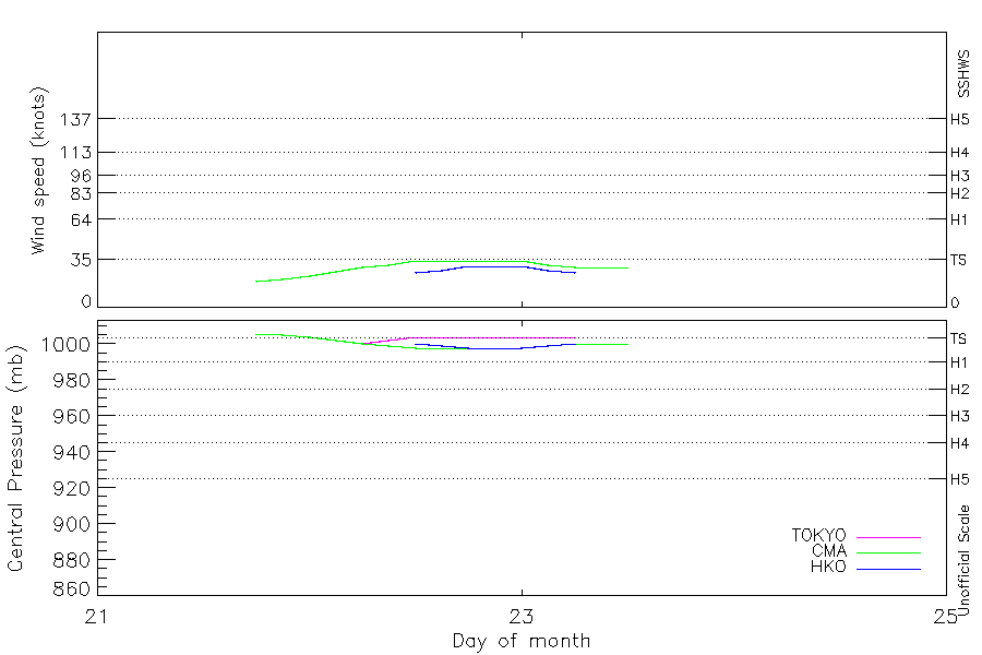
Intensity plots
|
Radial wind information
|
Position and Intensity Table
| BASIN |
ISO_TIME_________ |
NATURE |
LAT |
LON |
WMO WIND |
WMO PRES |
TOKYO WIND |
TOKYO PRES |
CMA WIND |
CMA PRES |
HKO WIND |
HKO PRES |
| |
|
|
degrees north |
degrees east |
kts |
mb |
kts |
mb |
kts |
mb |
kts |
mb |
| WP |
2004-11-21 18:00:00 |
TS |
15.60 |
124.90 |
|
1006 |
|
1006 |
19 |
1006 |
|
|
| WP |
21:00:00 |
TS |
15.58 |
124.24 |
|
|
|
1005 |
21 |
1005 |
|
|
| WP |
2004-11-22 00:00:00 |
TS |
15.60 |
123.60 |
|
1004 |
|
1004 |
23 |
1004 |
|
|
| WP |
03:00:00 |
TS |
15.66 |
123.01 |
|
|
|
1002 |
26 |
1002 |
|
|
| WP |
06:00:00 |
TS |
15.70 |
122.50 |
35 |
1000 |
35 |
1000 |
29 |
1000 |
|
|
| WP |
09:00:00 |
TS |
15.59 |
122.05 |
|
|
|
1002 |
31 |
999 |
|
|
| WP |
12:00:00 |
TS |
15.47 |
121.74 |
|
1004 |
|
1004 |
34 |
998 |
25 |
1000 |
| WP |
15:00:00 |
TS |
15.55 |
121.49 |
|
|
|
1004 |
34 |
998 |
27 |
999 |
| WP |
18:00:00 |
TS |
15.70 |
121.22 |
|
1004 |
|
1004 |
34 |
998 |
30 |
998 |
| WP |
21:00:00 |
TS |
15.82 |
120.88 |
|
|
|
1004 |
34 |
998 |
30 |
998 |
| WP |
2004-11-23 00:00:00 |
TS |
15.97 |
120.52 |
|
1004 |
|
1004 |
34 |
998 |
30 |
998 |
| WP |
03:00:00 |
TS |
16.16 |
120.04 |
|
|
|
1004 |
31 |
999 |
27 |
999 |
| WP |
06:00:00 |
TS |
16.38 |
119.54 |
|
1004 |
|
1004 |
29 |
1000 |
25 |
1000 |
| WP |
09:00:00 |
TS |
16.61 |
119.39 |
|
|
|
|
29 |
1000 |
|
|
| WP |
12:00:00 |
TS |
17.00 |
119.20 |
|
|
|
|
29 |
1000 |
|
|
Source Information
| Agency |
Information |
| USA |
|
| TOKYO |
bst_all.txt:Line=54363:MERBOK:426 |
| CMA |
CH2004BST.txt:Storm=31:Merbok |
| HKO |
tc-besttrack-data-current.txt:Line=31140:MERBOK |
| NEWDELHI |
|
| REUNION |
|
| BOM |
|
| NADI |
|
| WELLINGTON |
|
| DS824 |
|
| TD9636 |
|
| TD9635 |
|
| NEUMANN |
|
| MLC |
|
All available IBTrACS Data
| SEASON |
BASIN |
SUBBASIN |
ISO_TIME_________ |
NATURE |
LAT |
LON |
WMO WIND |
WMO PRES |
WMO AGENCY |
DIST2LAND |
LANDFALL |
IFLAG |
USA SSHS |
TOKYO LAT |
TOKYO LON |
TOKYO GRADE |
TOKYO WIND |
TOKYO PRES |
TOKYO R50_DIR |
TOKYO R30_DIR |
TOKYO R30_LONG |
TOKYO R30_SHORT |
TOKYO LAND |
CMA LAT |
CMA LON |
CMA CAT |
CMA WIND |
CMA PRES |
HKO LAT |
HKO LON |
HKO CAT |
HKO WIND |
HKO PRES |
STORM SPEED |
STORM DIR |
| Year |
|
|
|
|
degrees north |
degrees east |
kts |
mb |
|
km |
km |
|
1 |
degrees north |
degrees east |
1 |
kts |
mb |
|
|
nmile |
nmile |
1 |
degrees north |
degrees east |
1 |
kts |
mb |
degrees north |
degrees east |
|
kts |
mb |
kts |
degrees |
| 2004 |
WP |
MM |
2004-11-21 18:00:00 |
TS |
15.60 |
124.90 |
|
1006 |
tokyo |
190 |
179 |
_OO___________ |
-5 |
15.60 |
124.90 |
2 |
|
1006 |
0 |
0 |
|
|
0 |
15.60 |
124.90 |
0 |
19 |
1006 |
|
|
|
|
|
13 |
268 |
| 2004 |
WP |
MM |
21:00:00 |
TS |
15.58 |
124.24 |
|
|
|
179 |
164 |
_PP___________ |
-5 |
15.58 |
124.24 |
2 |
|
1005 |
0 |
0 |
|
|
|
15.59 |
124.24 |
0 |
21 |
1005 |
|
|
|
|
|
13 |
270 |
| 2004 |
WP |
MM |
2004-11-22 00:00:00 |
TS |
15.60 |
123.60 |
|
1004 |
tokyo |
164 |
102 |
_OO___________ |
-5 |
15.60 |
123.60 |
2 |
|
1004 |
0 |
0 |
|
|
0 |
15.60 |
123.60 |
1 |
23 |
1004 |
|
|
|
|
|
12 |
274 |
| 2004 |
WP |
MM |
03:00:00 |
TS |
15.66 |
123.01 |
|
|
|
102 |
61 |
_PP___________ |
-5 |
15.67 |
123.01 |
2 |
|
1002 |
0 |
0 |
|
|
|
15.66 |
123.01 |
1 |
26 |
1002 |
|
|
|
|
|
11 |
275 |
| 2004 |
WP |
MM |
06:00:00 |
TS |
15.70 |
122.50 |
35 |
1000 |
tokyo |
61 |
39 |
_OO___________ |
-5 |
15.70 |
122.50 |
3 |
35 |
1000 |
0 |
9 |
40 |
40 |
0 |
15.70 |
122.50 |
1 |
29 |
1000 |
|
|
|
|
|
9 |
266 |
| 2004 |
WP |
MM |
09:00:00 |
TS |
15.59 |
122.05 |
|
|
|
44 |
30 |
_PP___________ |
-5 |
15.53 |
122.05 |
3 |
|
1002 |
0 |
9 |
|
|
|
15.65 |
122.05 |
1 |
31 |
999 |
|
|
|
|
|
8 |
252 |
| 2004 |
WP |
MM |
12:00:00 |
TS |
15.47 |
121.74 |
|
1004 |
tokyo |
21 |
0 |
_OOO__________ |
-5 |
15.40 |
121.70 |
2 |
|
1004 |
0 |
0 |
|
|
0 |
15.60 |
121.70 |
2 |
34 |
998 |
15.20 |
122.10 |
TD |
25 |
1000 |
5 |
265 |
| 2004 |
WP |
MM |
15:00:00 |
TS |
15.55 |
121.49 |
|
|
|
0 |
0 |
_PPP__________ |
-5 |
15.50 |
121.46 |
2 |
|
1004 |
0 |
0 |
|
|
|
15.62 |
121.48 |
2 |
34 |
998 |
15.48 |
121.56 |
TD |
27 |
999 |
6 |
295 |
| 2004 |
WP |
MM |
18:00:00 |
TS |
15.70 |
121.22 |
|
1004 |
tokyo |
0 |
0 |
_OOO__________ |
-5 |
15.70 |
121.30 |
2 |
|
1004 |
0 |
0 |
|
|
0 |
15.70 |
121.30 |
2 |
34 |
998 |
15.70 |
121.00 |
TD |
30 |
998 |
6 |
295 |
| 2004 |
WP |
MM |
21:00:00 |
TS |
15.82 |
120.88 |
|
|
|
0 |
0 |
_PPP__________ |
-5 |
15.80 |
121.19 |
2 |
|
1004 |
0 |
0 |
|
|
|
15.83 |
121.04 |
2 |
34 |
998 |
15.83 |
120.41 |
TD |
30 |
998 |
7 |
292 |
| 2004 |
WP |
MM |
2004-11-23 00:00:00 |
TS |
15.97 |
120.52 |
|
1004 |
tokyo |
0 |
0 |
_OOO__________ |
-5 |
16.00 |
121.00 |
2 |
|
1004 |
0 |
0 |
|
|
0 |
16.00 |
120.70 |
2 |
34 |
998 |
15.90 |
119.80 |
TD |
30 |
998 |
9 |
292 |
| 2004 |
WP |
MM |
03:00:00 |
TS |
16.16 |
120.04 |
|
|
|
10 |
0 |
_PPP__________ |
-5 |
16.43 |
120.57 |
2 |
|
1004 |
0 |
0 |
|
|
|
16.12 |
120.19 |
2 |
31 |
999 |
15.95 |
119.20 |
TD |
27 |
999 |
10 |
294 |
| 2004 |
WP |
MM |
06:00:00 |
TS |
16.38 |
119.54 |
|
1004 |
tokyo |
33 |
33 |
_OOO__________ |
-5 |
17.00 |
120.00 |
2 |
|
1004 |
0 |
0 |
|
|
0 |
16.30 |
119.70 |
1 |
29 |
1000 |
16.00 |
118.60 |
TD |
25 |
1000 |
8 |
306 |
| 2004 |
WP |
MM |
09:00:00 |
TS |
16.61 |
119.39 |
|
|
|
54 |
54 |
__P___________ |
-5 |
|
|
2 |
|
|
0 |
0 |
|
|
|
16.61 |
119.39 |
1 |
29 |
1000 |
|
|
TD |
|
|
7 |
332 |
| 2004 |
WP |
MM |
12:00:00 |
TS |
17.00 |
119.20 |
|
|
|
101 |
|
__O___________ |
-5 |
|
|
|
|
|
|
|
|
|
|
17.00 |
119.20 |
1 |
29 |
1000 |
|
|
|
|
|
9 |
335 |