1980
Tropical Depression THELMA (1980269N14146)
IBTrACS version v04r00. Visit
IBTrACS website for data access.
Please direct all questions to the
IBTrACS Q and A forum
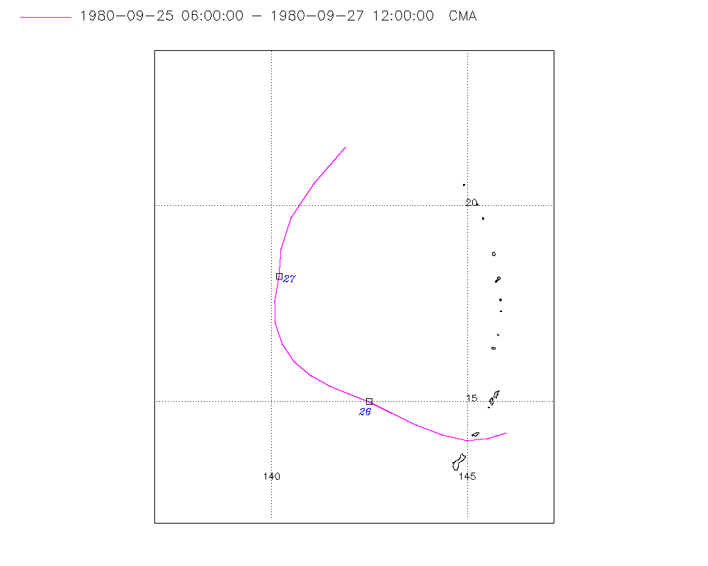
Storm track
-
Intensity
-
Wind Radii
-
Intensity Data
-
Source Data
-
All data
Summary Information
Storm track plot
|
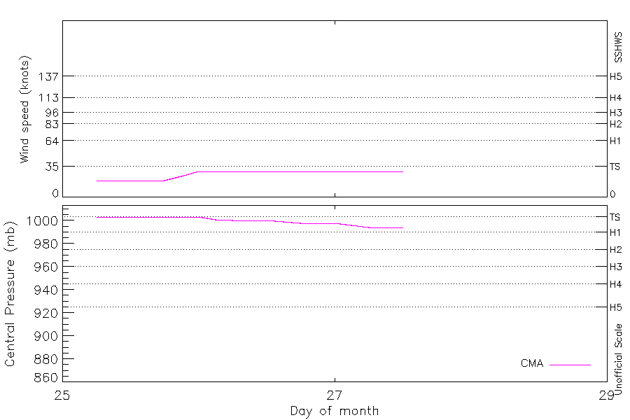
Intensity plots
|
Radial wind information
No radial wind information for this storm
|
Position and Intensity Table
| BASIN |
ISO_TIME_________ |
NATURE |
LAT |
LON |
CMA WIND |
CMA PRES |
| |
|
|
degrees north |
degrees east |
kts |
mb |
| WP |
1980-09-25 06:00:00 |
TS |
14.20 |
146.00 |
19 |
1003 |
| WP |
09:00:00 |
TS |
14.05 |
145.52 |
19 |
1003 |
| WP |
12:00:00 |
TS |
14.00 |
145.00 |
19 |
1003 |
| WP |
15:00:00 |
TS |
14.14 |
144.37 |
19 |
1003 |
| WP |
18:00:00 |
TS |
14.40 |
143.70 |
19 |
1003 |
| WP |
21:00:00 |
TS |
14.70 |
143.08 |
24 |
1003 |
| WP |
1980-09-26 00:00:00 |
TS |
15.00 |
142.50 |
29 |
1003 |
| WP |
03:00:00 |
TS |
15.20 |
141.98 |
29 |
1001 |
| WP |
06:00:00 |
TS |
15.40 |
141.50 |
29 |
1000 |
| WP |
09:00:00 |
TS |
15.66 |
141.01 |
29 |
1000 |
| WP |
12:00:00 |
TS |
16.00 |
140.60 |
29 |
1000 |
| WP |
15:00:00 |
TS |
16.45 |
140.28 |
29 |
999 |
| WP |
18:00:00 |
TS |
17.00 |
140.10 |
29 |
998 |
| WP |
21:00:00 |
TS |
17.56 |
140.09 |
29 |
998 |
| WP |
1980-09-27 00:00:00 |
TS |
18.20 |
140.20 |
29 |
998 |
| WP |
03:00:00 |
TS |
18.90 |
140.25 |
29 |
996 |
| WP |
06:00:00 |
TS |
19.70 |
140.50 |
29 |
994 |
| WP |
09:00:00 |
TS |
20.68 |
141.15 |
29 |
994 |
| WP |
12:00:00 |
TS |
21.50 |
141.90 |
29 |
994 |
| WP |
15:00:00 |
TS |
21.85 |
142.51 |
|
|
Source Information
| Agency |
Information |
| USA |
|
| TOKYO |
|
| CMA |
CH1980BST.txt:Storm=25:Thelma |
| HKO |
|
| NEWDELHI |
|
| REUNION |
|
| BOM |
|
| NADI |
|
| WELLINGTON |
|
| DS824 |
|
| TD9636 |
|
| TD9635 |
|
| NEUMANN |
|
| MLC |
|
All available IBTrACS Data
| SEASON |
BASIN |
SUBBASIN |
ISO_TIME_________ |
NATURE |
LAT |
LON |
DIST2LAND |
LANDFALL |
IFLAG |
USA SSHS |
CMA LAT |
CMA LON |
CMA CAT |
CMA WIND |
CMA PRES |
STORM SPEED |
STORM DIR |
| Year |
|
|
|
|
degrees north |
degrees east |
km |
km |
|
1 |
degrees north |
degrees east |
1 |
kts |
mb |
kts |
degrees |
| 1980 |
WP |
MM |
1980-09-25 06:00:00 |
TS |
14.20 |
146.00 |
1827 |
1817 |
__O___________ |
-5 |
14.20 |
146.00 |
0 |
19 |
1003 |
10 |
252 |
| 1980 |
WP |
MM |
09:00:00 |
TS |
14.05 |
145.52 |
1807 |
1807 |
__P___________ |
-5 |
14.05 |
145.53 |
0 |
19 |
1003 |
10 |
258 |
| 1980 |
WP |
MM |
12:00:00 |
TS |
14.00 |
145.00 |
1812 |
1812 |
__O___________ |
-5 |
14.00 |
145.00 |
0 |
19 |
1003 |
11 |
275 |
| 1980 |
WP |
MM |
15:00:00 |
TS |
14.14 |
144.37 |
1831 |
1831 |
__P___________ |
-5 |
14.14 |
144.37 |
0 |
19 |
1003 |
13 |
288 |
| 1980 |
WP |
MM |
18:00:00 |
TS |
14.40 |
143.70 |
1875 |
1875 |
__O___________ |
-5 |
14.40 |
143.70 |
0 |
19 |
1003 |
14 |
294 |
| 1980 |
WP |
MM |
21:00:00 |
TS |
14.70 |
143.08 |
1904 |
1864 |
__P___________ |
-5 |
14.70 |
143.08 |
0 |
24 |
1003 |
13 |
297 |
| 1980 |
WP |
MM |
1980-09-26 00:00:00 |
TS |
15.00 |
142.50 |
1864 |
1814 |
__O___________ |
-5 |
15.00 |
142.50 |
1 |
29 |
1003 |
12 |
295 |
| 1980 |
WP |
MM |
03:00:00 |
TS |
15.20 |
141.98 |
1814 |
1764 |
__P___________ |
-5 |
15.20 |
141.98 |
1 |
29 |
1001 |
10 |
293 |
| 1980 |
WP |
MM |
06:00:00 |
TS |
15.40 |
141.50 |
1764 |
1716 |
__O___________ |
-5 |
15.40 |
141.50 |
1 |
29 |
1000 |
10 |
296 |
| 1980 |
WP |
MM |
09:00:00 |
TS |
15.66 |
141.01 |
1718 |
1683 |
__P___________ |
-5 |
15.66 |
141.01 |
1 |
29 |
1000 |
11 |
305 |
| 1980 |
WP |
MM |
12:00:00 |
TS |
16.00 |
140.60 |
1683 |
1659 |
__O___________ |
-5 |
16.00 |
140.60 |
1 |
29 |
1000 |
11 |
318 |
| 1980 |
WP |
MM |
15:00:00 |
TS |
16.45 |
140.28 |
1665 |
1653 |
__P___________ |
-5 |
16.45 |
140.28 |
1 |
29 |
999 |
11 |
334 |
| 1980 |
WP |
MM |
18:00:00 |
TS |
17.00 |
140.10 |
1660 |
1660 |
__O___________ |
-5 |
17.00 |
140.10 |
1 |
29 |
998 |
11 |
351 |
| 1980 |
WP |
MM |
21:00:00 |
TS |
17.56 |
140.09 |
1681 |
1681 |
__P___________ |
-5 |
17.56 |
140.09 |
1 |
29 |
998 |
12 |
5 |
| 1980 |
WP |
MM |
1980-09-27 00:00:00 |
TS |
18.20 |
140.20 |
1713 |
1651 |
__O___________ |
-5 |
18.20 |
140.20 |
1 |
29 |
998 |
14 |
7 |
| 1980 |
WP |
MM |
03:00:00 |
TS |
18.90 |
140.25 |
1657 |
1592 |
__P___________ |
-5 |
18.90 |
140.25 |
1 |
29 |
996 |
15 |
11 |
| 1980 |
WP |
MM |
06:00:00 |
TS |
19.70 |
140.50 |
1592 |
1521 |
__O___________ |
-5 |
19.70 |
140.50 |
1 |
29 |
994 |
20 |
25 |
| 1980 |
WP |
MM |
09:00:00 |
TS |
20.68 |
141.15 |
1514 |
1457 |
__P___________ |
-5 |
20.58 |
141.09 |
1 |
29 |
994 |
22 |
36 |
| 1980 |
WP |
MM |
12:00:00 |
TS |
21.50 |
141.90 |
1457 |
1443 |
__O___________ |
-5 |
21.50 |
141.90 |
1 |
29 |
994 |
17 |
47 |
| 1980 |
WP |
MM |
15:00:00 |
TS |
21.85 |
142.51 |
1452 |
|
______________ |
-5 |
|
|
1 |
|
|
13 |
58 |