1979
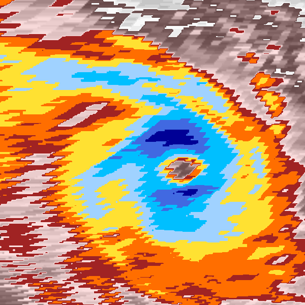
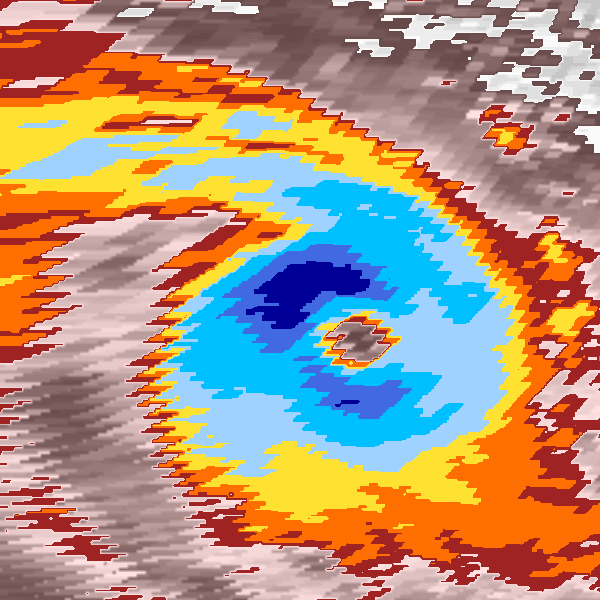
Tropical Cyclone NOT_NAMED (1979094S15429)
IBTrACS version v04r00. Visit
IBTrACS website for data access.
Please direct all questions to the
IBTrACS Q and A forum
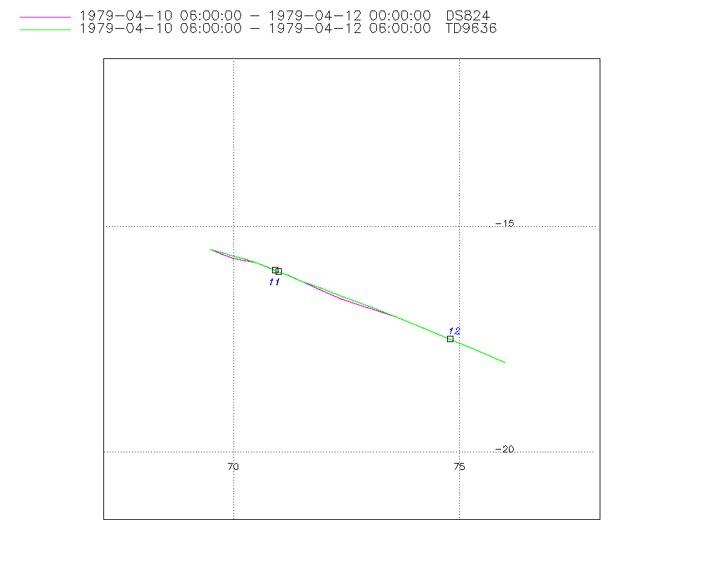
Storm track
-
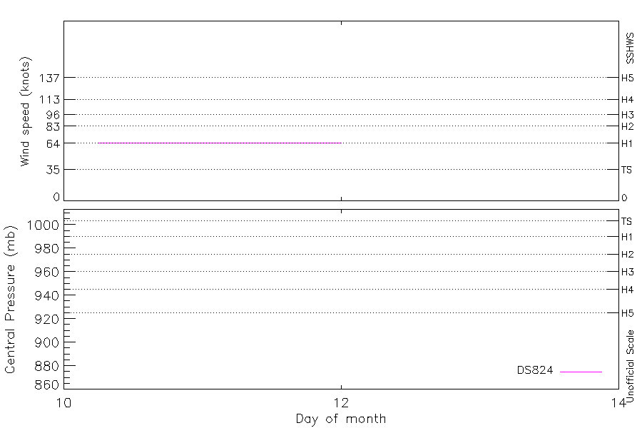
Intensity
-
Wind Radii
-
Intensity Data
-
Source Data
-
All data
Summary Information
|
| Storm ID |
1979094S15429 |
| Start |
Apr 10 03Z |
| Max Intensity |
65 kt (Apr 10 06Z) |
| End |
Apr 12 06Z |
| ATCF IDs |
|
| Track status |
Best track data. |
|
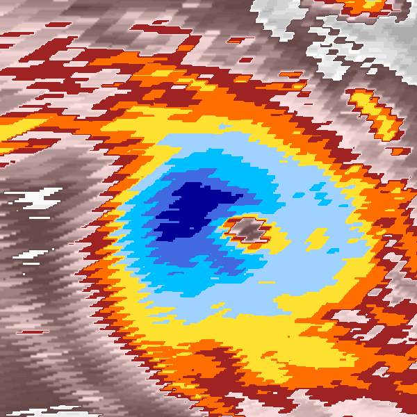
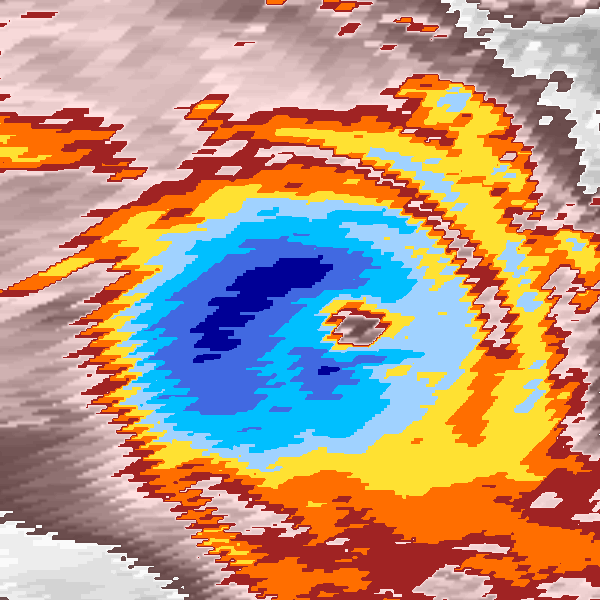
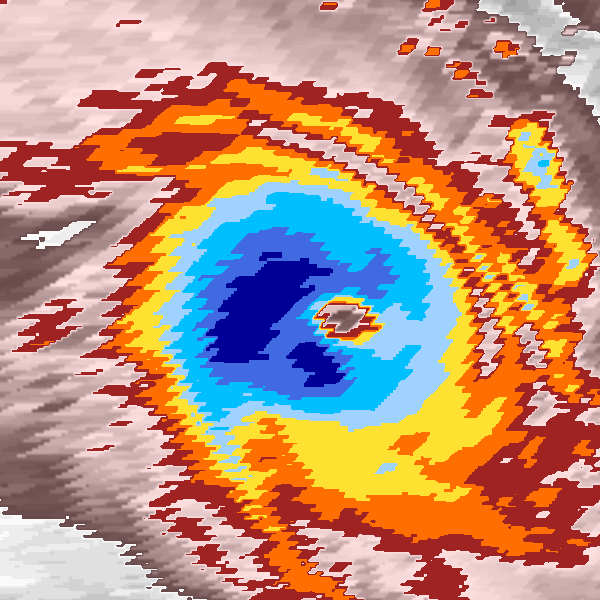
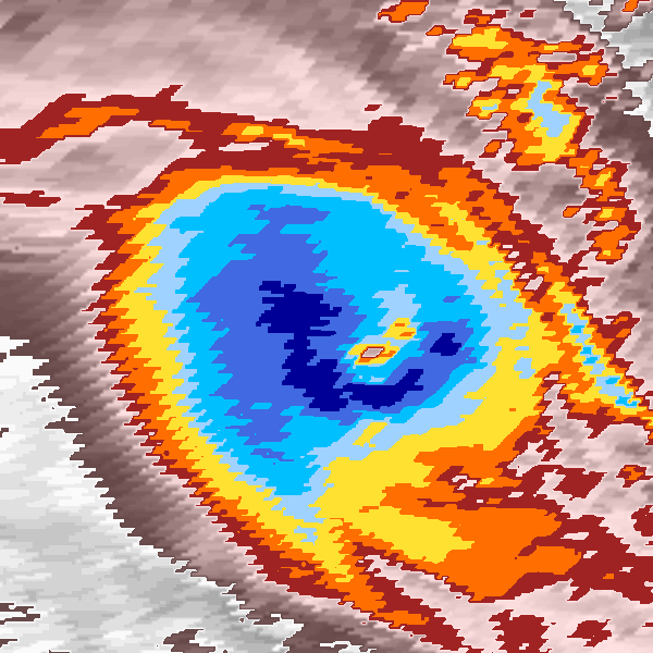
Storm track plot
|
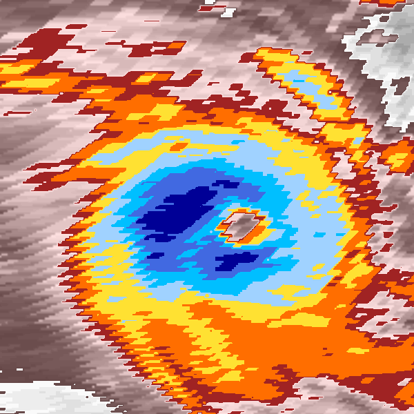
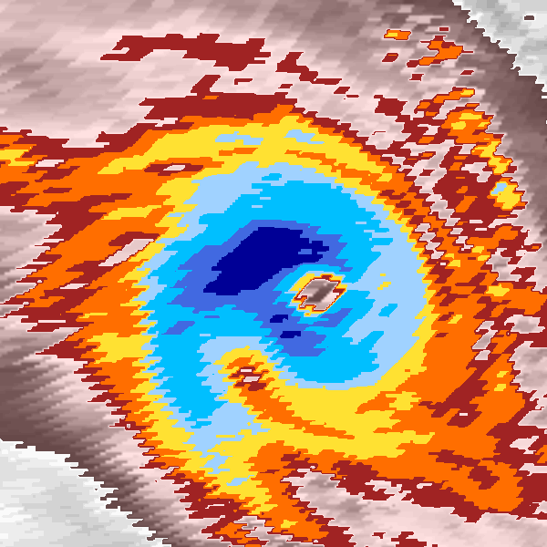
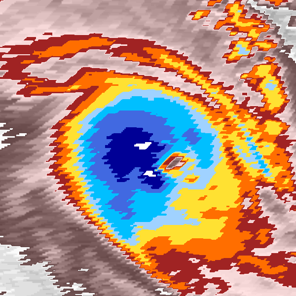
Intensity plots
|
Radial wind information
No radial wind information for this storm
|
Position and Intensity Table
| BASIN |
ISO_TIME_________ |
NATURE |
LAT |
LON |
DS824 WIND |
| |
|
|
degrees north |
degrees east |
kts |
| SI |
1979-04-10 03:00:00 |
TS |
-15.40 |
69.24 |
|
| SI |
06:00:00 |
TS |
-15.50 |
69.50 |
65 |
| SI |
09:00:00 |
TS |
-15.60 |
69.75 |
65 |
| SI |
12:00:00 |
TS |
-15.68 |
70.00 |
65 |
| SI |
15:00:00 |
TS |
-15.74 |
70.25 |
65 |
| SI |
18:00:00 |
TS |
-15.80 |
70.50 |
65 |
| SI |
21:00:00 |
TS |
-15.88 |
70.73 |
65 |
| SI |
1979-04-11 00:00:00 |
TS |
-15.98 |
70.96 |
65 |
| SI |
03:00:00 |
TS |
-16.08 |
71.20 |
65 |
| SI |
06:00:00 |
TS |
-16.20 |
71.50 |
65 |
| SI |
09:00:00 |
TS |
-16.37 |
71.92 |
65 |
| SI |
12:00:00 |
TS |
-16.58 |
72.42 |
65 |
| SI |
15:00:00 |
TS |
-16.78 |
72.99 |
65 |
| SI |
18:00:00 |
TS |
-17.00 |
73.60 |
65 |
| SI |
21:00:00 |
TS |
-17.23 |
74.17 |
65 |
| SI |
1979-04-12 00:00:00 |
TS |
-17.47 |
74.76 |
65 |
| SI |
03:00:00 |
TS |
-17.71 |
75.36 |
|
| SI |
06:00:00 |
NR |
-18.00 |
76.00 |
|
Source Information
| Agency |
Information |
| USA |
|
| TOKYO |
|
| CMA |
|
| HKO |
|
| NEWDELHI |
|
| REUNION |
|
| BOM |
|
| NADI |
|
| WELLINGTON |
|
| DS824 |
s_hem.dat:1403:25S |
| TD9636 |
cons_worldwide_trop_cyclone_18710101-19891231-005:Line=11687 |
| TD9635 |
|
| NEUMANN |
|
| MLC |
|
All available IBTrACS Data
| SEASON |
BASIN |
SUBBASIN |
ISO_TIME_________ |
NATURE |
LAT |
LON |
DIST2LAND |
LANDFALL |
IFLAG |
USA SSHS |
DS824 LAT |
DS824 LON |
DS824 STAGE |
DS824 WIND |
TD9636 LAT |
TD9636 LON |
TD9636 STAGE |
STORM SPEED |
STORM DIR |
| Year |
|
|
|
|
degrees north |
degrees east |
km |
km |
|
1 |
degrees north |
degrees east |
|
kts |
degrees north |
degrees east |
|
kts |
degrees |
| 1979 |
SI |
MM |
1979-04-10 03:00:00 |
TS |
-15.40 |
69.24 |
1324 |
1324 |
______________ |
-5 |
|
|
|
|
|
|
|
5 |
111 |
| 1979 |
SI |
MM |
06:00:00 |
TS |
-15.50 |
69.50 |
1349 |
1349 |
_________OO___ |
-5 |
-15.50 |
69.50 |
TC |
65 |
-15.50 |
69.50 |
4 |
5 |
111 |
| 1979 |
SI |
MM |
09:00:00 |
TS |
-15.60 |
69.75 |
1373 |
1373 |
_________PP___ |
-5 |
-15.61 |
69.75 |
TC |
65 |
-15.58 |
69.77 |
4 |
5 |
110 |
| 1979 |
SI |
MM |
12:00:00 |
TS |
-15.68 |
70.00 |
1388 |
1388 |
_________OP___ |
-5 |
-15.70 |
70.00 |
TC |
65 |
-15.65 |
70.03 |
4 |
5 |
106 |
| 1979 |
SI |
MM |
15:00:00 |
TS |
-15.74 |
70.25 |
1418 |
1413 |
_________PP___ |
-5 |
-15.75 |
70.25 |
TC |
65 |
-15.73 |
70.27 |
4 |
5 |
104 |
| 1979 |
SI |
MM |
18:00:00 |
TS |
-15.80 |
70.50 |
1433 |
1433 |
_________OO___ |
-5 |
-15.80 |
70.50 |
TC |
65 |
-15.80 |
70.50 |
4 |
5 |
108 |
| 1979 |
SI |
MM |
21:00:00 |
TS |
-15.88 |
70.73 |
1449 |
1449 |
_________PP___ |
-5 |
-15.89 |
70.75 |
TC |
65 |
-15.88 |
70.71 |
4 |
5 |
112 |
| 1979 |
SI |
MM |
1979-04-11 00:00:00 |
TS |
-15.98 |
70.96 |
1474 |
1474 |
_________OP___ |
-5 |
-16.00 |
71.00 |
TC |
65 |
-15.96 |
70.92 |
4 |
5 |
113 |
| 1979 |
SI |
MM |
03:00:00 |
TS |
-16.08 |
71.20 |
1490 |
1490 |
_________PP___ |
-5 |
-16.08 |
71.22 |
TC |
65 |
-16.07 |
71.17 |
4 |
6 |
113 |
| 1979 |
SI |
MM |
06:00:00 |
TS |
-16.20 |
71.50 |
1517 |
1517 |
_________OO___ |
-5 |
-16.20 |
71.50 |
TC |
65 |
-16.20 |
71.50 |
4 |
8 |
113 |
| 1979 |
SI |
MM |
09:00:00 |
TS |
-16.37 |
71.92 |
1550 |
1550 |
_________PP___ |
-5 |
-16.38 |
71.90 |
TC |
65 |
-16.36 |
71.93 |
4 |
10 |
113 |
| 1979 |
SI |
MM |
12:00:00 |
TS |
-16.58 |
72.42 |
1594 |
1594 |
_________OP___ |
-5 |
-16.60 |
72.40 |
TC |
65 |
-16.56 |
72.45 |
4 |
11 |
112 |
| 1979 |
SI |
MM |
15:00:00 |
TS |
-16.78 |
72.99 |
1648 |
1648 |
_________PP___ |
-5 |
-16.79 |
72.98 |
TC |
65 |
-16.77 |
73.01 |
4 |
12 |
111 |
| 1979 |
SI |
MM |
18:00:00 |
TS |
-17.00 |
73.60 |
1704 |
1704 |
_________OO___ |
-5 |
-17.00 |
73.60 |
TC |
65 |
-17.00 |
73.60 |
4 |
12 |
112 |
| 1979 |
SI |
MM |
21:00:00 |
TS |
-17.23 |
74.17 |
1760 |
1757 |
_________PP___ |
-5 |
-17.24 |
74.21 |
TC |
65 |
-17.24 |
74.20 |
4 |
12 |
113 |
| 1979 |
SI |
MM |
1979-04-12 00:00:00 |
TS |
-17.47 |
74.76 |
1814 |
1814 |
_________OP___ |
-5 |
-17.50 |
74.80 |
TC |
65 |
-17.49 |
74.80 |
4 |
12 |
113 |
| 1979 |
SI |
MM |
03:00:00 |
TS |
-17.71 |
75.36 |
1872 |
1872 |
__________P___ |
-5 |
|
|
TC |
|
-17.74 |
75.40 |
4 |
13 |
114 |
| 1979 |
SI |
MM |
06:00:00 |
NR |
-18.00 |
76.00 |
1927 |
|
__________O___ |
-5 |
|
|
|
|
-18.00 |
76.00 |
4 |
13 |
115 |