1977
Tropical Depression NOT_NAMED (1977239N22151)
IBTrACS version v04r00. Visit
IBTrACS website for data access.
Please direct all questions to the
IBTrACS Q and A forum
Storm track
-
Intensity
-
Wind Radii
-
Intensity Data
-
Source Data
-
All data
Summary Information
|
|
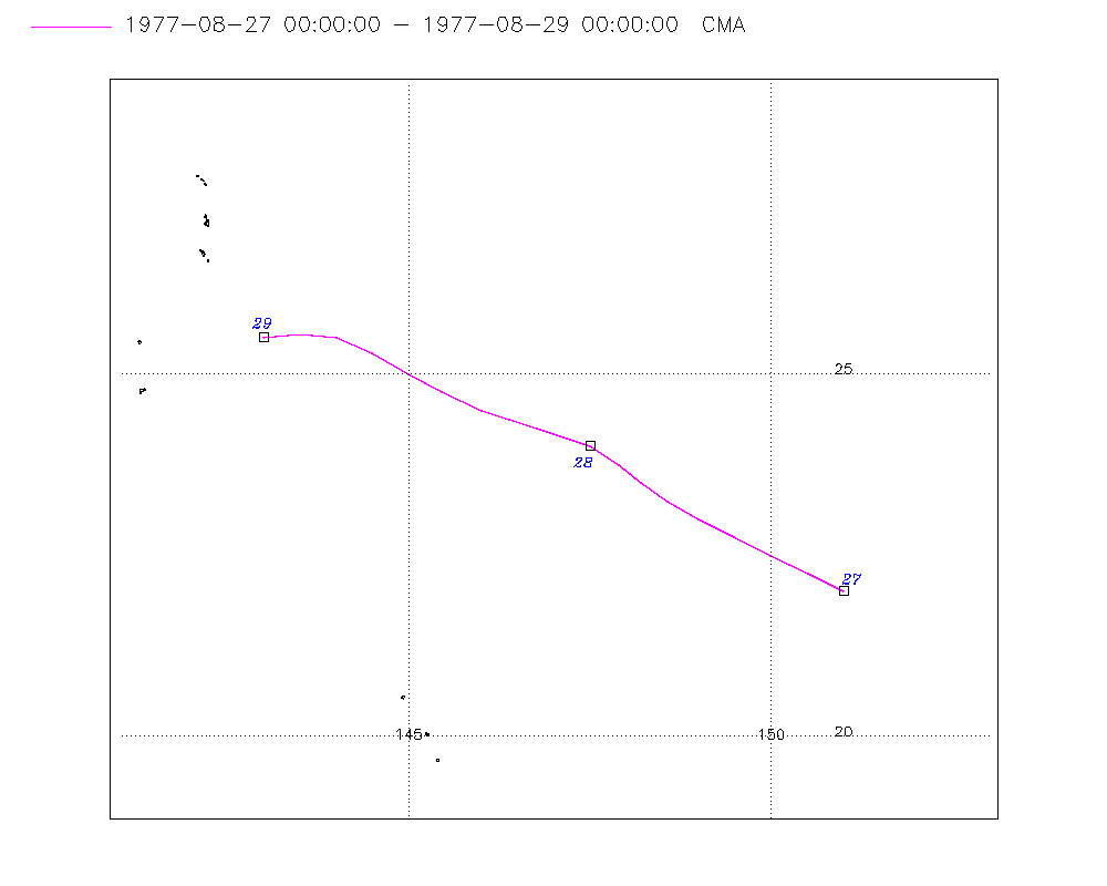
| Storm ID |
1977239N22151 |
| Start |
Aug 27 00Z |
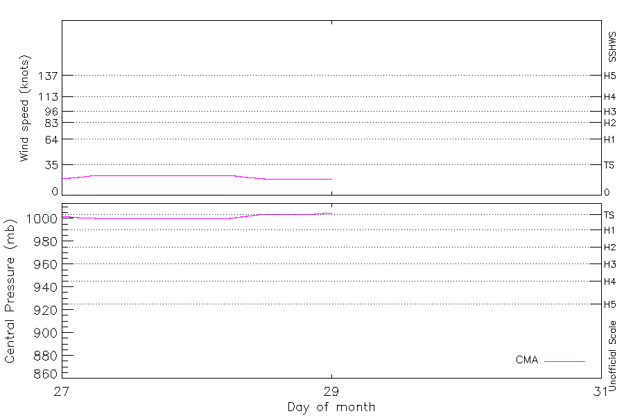
| Max Intensity |
23 kt (Aug 27 06Z) |
| End |
Aug 29 00Z |
| ATCF IDs |
|
| Track status |
Best track data. |
|
Storm track plot
|
Intensity plots
|
Radial wind information
No radial wind information for this storm
|
Position and Intensity Table
| BASIN |
ISO_TIME_________ |
NATURE |
LAT |
LON |
CMA WIND |
CMA PRES |
| |
|
|
degrees north |
degrees east |
kts |
mb |
| WP |
1977-08-27 00:00:00 |
TS |
22.00 |
151.00 |
19 |
1002 |
| WP |
03:00:00 |
TS |
22.25 |
150.51 |
21 |
1001 |
| WP |
06:00:00 |
TS |
22.50 |
150.00 |
23 |
1000 |
| WP |
09:00:00 |
TS |
22.75 |
149.48 |
23 |
1000 |
| WP |
12:00:00 |
TS |
23.00 |
149.00 |
23 |
1000 |
| WP |
15:00:00 |
TS |
23.25 |
148.58 |
23 |
1000 |
| WP |
18:00:00 |
TS |
23.50 |
148.20 |
23 |
1000 |
| WP |
21:00:00 |
TS |
23.75 |
147.90 |
23 |
1000 |
| WP |
1977-08-28 00:00:00 |
TS |
24.00 |
147.50 |
23 |
1000 |
| WP |
03:00:00 |
TS |
24.25 |
146.77 |
23 |
1000 |
| WP |
06:00:00 |
TS |
24.50 |
146.00 |
23 |
1000 |
| WP |
09:00:00 |
TS |
24.75 |
145.46 |
21 |
1002 |
| WP |
12:00:00 |
TS |
25.00 |
145.00 |
19 |
1004 |
| WP |
15:00:00 |
TS |
25.29 |
144.50 |
19 |
1004 |
| WP |
18:00:00 |
TS |
25.50 |
144.00 |
19 |
1004 |
| WP |
21:00:00 |
TS |
25.55 |
143.50 |
19 |
1004 |
| WP |
1977-08-29 00:00:00 |
TS |
25.50 |
143.00 |
19 |
1005 |
Source Information
| Agency |
Information |
| USA |
|
| TOKYO |
|
| CMA |
CH1977BST.txt:Storm=14:(nameless) |
| HKO |
|
| NEWDELHI |
|
| REUNION |
|
| BOM |
|
| NADI |
|
| WELLINGTON |
|
| DS824 |
|
| TD9636 |
|
| TD9635 |
|
| NEUMANN |
|
| MLC |
|
All available IBTrACS Data
| SEASON |
BASIN |
SUBBASIN |
ISO_TIME_________ |
NATURE |
LAT |
LON |
DIST2LAND |
LANDFALL |
IFLAG |
USA SSHS |
CMA LAT |
CMA LON |
CMA CAT |
CMA WIND |
CMA PRES |
STORM SPEED |
STORM DIR |
| Year |
|
|
|
|
degrees north |
degrees east |
km |
km |
|
1 |
degrees north |
degrees east |
1 |
kts |
mb |
kts |
degrees |
| 1977 |
WP |
MM |
1977-08-27 00:00:00 |
TS |
22.00 |
151.00 |
1797 |
1750 |
__O___________ |
-5 |
22.00 |
151.00 |
0 |
19 |
1002 |
10 |
299 |
| 1977 |
WP |
MM |
03:00:00 |
TS |
22.25 |
150.51 |
1741 |
1695 |
__P___________ |
-5 |
22.25 |
150.51 |
0 |
21 |
1001 |
11 |
298 |
| 1977 |
WP |
MM |
06:00:00 |
TS |
22.50 |
150.00 |
1695 |
1649 |
__O___________ |
-5 |
22.50 |
150.00 |
1 |
23 |
1000 |
11 |
298 |
| 1977 |
WP |
MM |
09:00:00 |
TS |
22.75 |
149.48 |
1649 |
1593 |
__P___________ |
-5 |
22.75 |
149.48 |
1 |
23 |
1000 |
11 |
298 |
| 1977 |
WP |
MM |
12:00:00 |
TS |
23.00 |
149.00 |
1593 |
1553 |
__O___________ |
-5 |
23.00 |
149.00 |
1 |
23 |
1000 |
10 |
301 |
| 1977 |
WP |
MM |
15:00:00 |
TS |
23.25 |
148.58 |
1553 |
1503 |
__P___________ |
-5 |
23.25 |
148.58 |
1 |
23 |
1000 |
9 |
304 |
| 1977 |
WP |
MM |
18:00:00 |
TS |
23.50 |
148.20 |
1503 |
1469 |
__O___________ |
-5 |
23.50 |
148.20 |
1 |
23 |
1000 |
8 |
309 |
| 1977 |
WP |
MM |
21:00:00 |
TS |
23.75 |
147.90 |
1469 |
1420 |
__P___________ |
-5 |
23.75 |
147.90 |
1 |
23 |
1000 |
8 |
308 |
| 1977 |
WP |
MM |
1977-08-28 00:00:00 |
TS |
24.00 |
147.50 |
1420 |
1366 |
__O___________ |
-5 |
24.00 |
147.50 |
1 |
23 |
1000 |
11 |
296 |
| 1977 |
WP |
MM |
03:00:00 |
TS |
24.25 |
146.77 |
1356 |
1300 |
__P___________ |
-5 |
24.25 |
146.77 |
1 |
23 |
1000 |
15 |
290 |
| 1977 |
WP |
MM |
06:00:00 |
TS |
24.50 |
146.00 |
1300 |
1259 |
__O___________ |
-5 |
24.50 |
146.00 |
1 |
23 |
1000 |
13 |
293 |
| 1977 |
WP |
MM |
09:00:00 |
TS |
24.75 |
145.46 |
1259 |
1208 |
__P___________ |
-5 |
24.75 |
145.46 |
1 |
21 |
1002 |
10 |
299 |
| 1977 |
WP |
MM |
12:00:00 |
TS |
25.00 |
145.00 |
1208 |
1158 |
__O___________ |
-5 |
25.00 |
145.00 |
0 |
19 |
1004 |
10 |
302 |
| 1977 |
WP |
MM |
15:00:00 |
TS |
25.29 |
144.50 |
1158 |
1119 |
__P___________ |
-5 |
25.29 |
144.50 |
0 |
19 |
1004 |
10 |
299 |
| 1977 |
WP |
MM |
18:00:00 |
TS |
25.50 |
144.00 |
1119 |
1093 |
__O___________ |
-5 |
25.50 |
144.00 |
0 |
19 |
1004 |
9 |
286 |
| 1977 |
WP |
MM |
21:00:00 |
TS |
25.55 |
143.50 |
1093 |
1090 |
__P___________ |
-5 |
25.55 |
143.50 |
0 |
19 |
1004 |
9 |
270 |
| 1977 |
WP |
MM |
1977-08-29 00:00:00 |
TS |
25.50 |
143.00 |
1090 |
|
__O___________ |
-5 |
25.50 |
143.00 |
0 |
19 |
1005 |
9 |
264 |