1977
Moderate Tropical Storm IO:JACK (1977057S28060)
IBTrACS version v04r00. Visit
IBTrACS website for data access.
Please direct all questions to the
IBTrACS Q and A forum
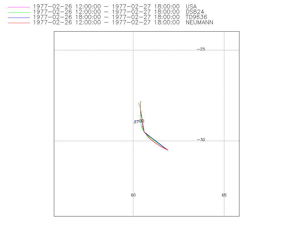
Storm track
-
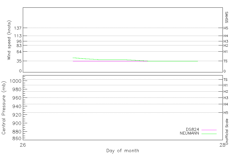
Intensity
-
Wind Radii
-
Intensity Data
-
Source Data
-
All data
Summary Information
|
|
| Storm ID |
1977057S28060 |
| Start |
Feb 26 09Z |
| Max Intensity |
45 kt (Feb 26 12Z) |
| End |
Feb 27 18Z |
| ATCF IDs |
,SH141977 |
| Track status |
Best track data. |
|
Storm track plot
|
Intensity plots
|
Radial wind information
No radial wind information for this storm
|
Position and Intensity Table
| BASIN |
ISO_TIME_________ |
NATURE |
LAT |
LON |
DS824 WIND |
NEUMANN WIND |
| |
|
|
degrees north |
degrees east |
kts |
kts |
| SI |
1977-02-26 09:00:00 |
TS |
-27.68 |
60.30 |
|
|
| SI |
12:00:00 |
MX |
-27.88 |
60.31 |
35 |
45 |
| SI |
15:00:00 |
MX |
-28.08 |
60.35 |
35 |
42 |
| SI |
18:00:00 |
MX |
-28.30 |
60.40 |
35 |
40 |
| SI |
21:00:00 |
MX |
-28.59 |
60.40 |
35 |
40 |
| SI |
1977-02-27 00:00:00 |
MX |
-28.90 |
60.43 |
35 |
40 |
| SI |
03:00:00 |
MX |
-29.20 |
60.47 |
35 |
37 |
| SI |
06:00:00 |
MX |
-29.50 |
60.60 |
35 |
35 |
| SI |
09:00:00 |
MX |
-29.78 |
60.86 |
35 |
35 |
| SI |
12:00:00 |
MX |
-30.03 |
61.19 |
35 |
35 |
| SI |
15:00:00 |
MX |
-30.28 |
61.53 |
35 |
35 |
| SI |
18:00:00 |
MX |
-30.50 |
61.90 |
35 |
35 |
Source Information
| Agency |
Information |
| USA |
bsh141977.txt |
| TOKYO |
|
| CMA |
|
| HKO |
|
| NEWDELHI |
|
| REUNION |
|
| BOM |
|
| NADI |
|
| WELLINGTON |
|
| DS824 |
s_hem.dat:1335:14S |
| TD9636 |
cons_worldwide_trop_cyclone_18710101-19891231-005:Line=11196 |
| TD9635 |
|
| NEUMANN |
tracks.sh:Storm=496:JACK/IO:BSH1477:BM480&Reunion |
| MLC |
|
All available IBTrACS Data
| SEASON |
BASIN |
SUBBASIN |
ISO_TIME_________ |
NATURE |
LAT |
LON |
DIST2LAND |
LANDFALL |
IFLAG |
USA AGENCY |
USA ATCF_ID |
USA LAT |
USA LON |
USA SSHS |
DS824 LAT |
DS824 LON |
DS824 STAGE |
DS824 WIND |
TD9636 LAT |
TD9636 LON |
TD9636 STAGE |
NEUMANN LAT |
NEUMANN LON |
NEUMANN CLASS |
NEUMANN WIND |
STORM SPEED |
STORM DIR |
| Year |
|
|
|
|
degrees north |
degrees east |
km |
km |
|
|
|
degrees north |
degrees east |
1 |
degrees north |
degrees east |
|
kts |
degrees north |
degrees east |
|
degrees north |
degrees east |
|
kts |
kts |
degrees |
| 1977 |
SI |
MM |
1977-02-26 09:00:00 |
TS |
-27.68 |
60.30 |
846 |
846 |
______________ |
|
|
|
|
-5 |
|
|
|
|
|
|
|
|
|
|
|
4 |
172 |
| 1977 |
SI |
MM |
12:00:00 |
MX |
-27.88 |
60.31 |
866 |
866 |
O________O__O_ |
jtwc_sh |
SH141977 |
-27.90 |
60.30 |
-5 |
-27.90 |
60.30 |
TC |
35 |
|
|
|
-27.80 |
60.40 |
EX |
45 |
4 |
175 |
| 1977 |
SI |
MM |
15:00:00 |
MX |
-28.08 |
60.35 |
885 |
885 |
P________P__P_ |
|
SH141977 |
-28.08 |
60.36 |
-5 |
-28.08 |
60.36 |
TC |
35 |
|
|
|
-28.04 |
60.39 |
EX |
42 |
4 |
170 |
| 1977 |
SI |
MM |
18:00:00 |
MX |
-28.30 |
60.40 |
909 |
909 |
O________OO_O_ |
jtwc_sh |
SH141977 |
-28.30 |
60.40 |
-5 |
-28.30 |
60.40 |
TC |
35 |
-28.30 |
60.40 |
2 |
-28.30 |
60.40 |
EX |
40 |
5 |
173 |
| 1977 |
SI |
MM |
21:00:00 |
MX |
-28.59 |
60.40 |
937 |
937 |
P________PP_P_ |
|
SH141977 |
-28.58 |
60.39 |
-5 |
-28.58 |
60.39 |
TC |
35 |
-28.60 |
60.45 |
2 |
-28.59 |
60.44 |
EX |
40 |
6 |
0 |
| 1977 |
SI |
MM |
1977-02-27 00:00:00 |
MX |
-28.90 |
60.43 |
966 |
966 |
O________OP_O_ |
jtwc_sh |
SH141977 |
-28.90 |
60.40 |
-5 |
-28.90 |
60.40 |
TC |
35 |
-28.90 |
60.50 |
2 |
-28.90 |
60.50 |
EX |
40 |
6 |
175 |
| 1977 |
SI |
MM |
03:00:00 |
MX |
-29.20 |
60.47 |
1000 |
1000 |
P________PP_P_ |
|
SH141977 |
-29.21 |
60.46 |
-5 |
-29.21 |
60.46 |
TC |
35 |
-29.20 |
60.55 |
2 |
-29.20 |
60.51 |
EX |
37 |
6 |
166 |
| 1977 |
SI |
MM |
06:00:00 |
MX |
-29.50 |
60.60 |
1034 |
1034 |
O________OO_O_ |
jtwc_sh |
SH141977 |
-29.50 |
60.60 |
-5 |
-29.50 |
60.60 |
TC |
35 |
-29.50 |
60.60 |
2 |
-29.50 |
60.60 |
EX |
35 |
7 |
150 |
| 1977 |
SI |
MM |
09:00:00 |
MX |
-29.78 |
60.86 |
1077 |
1077 |
P________PP_P_ |
|
SH141977 |
-29.76 |
60.86 |
-5 |
-29.76 |
60.86 |
TC |
35 |
-29.75 |
60.92 |
2 |
-29.82 |
60.85 |
EX |
35 |
7 |
136 |
| 1977 |
SI |
MM |
12:00:00 |
MX |
-30.03 |
61.19 |
1111 |
1111 |
O________OP_O_ |
jtwc_sh |
SH141977 |
-30.00 |
61.20 |
-5 |
-30.00 |
61.20 |
TC |
35 |
-30.00 |
61.25 |
2 |
-30.10 |
61.20 |
EX |
35 |
8 |
131 |
| 1977 |
SI |
MM |
15:00:00 |
MX |
-30.28 |
61.53 |
1155 |
1155 |
P________PP_P_ |
|
SH141977 |
-30.25 |
61.55 |
-5 |
-30.25 |
61.55 |
TC |
35 |
-30.25 |
61.57 |
2 |
-30.32 |
61.55 |
EX |
35 |
8 |
127 |
| 1977 |
SI |
MM |
18:00:00 |
MX |
-30.50 |
61.90 |
1193 |
|
O________OO_O_ |
jtwc_sh |
SH141977 |
-30.50 |
61.90 |
-5 |
-30.50 |
61.90 |
TC |
35 |
-30.50 |
61.90 |
2 |
-30.50 |
61.90 |
EX |
35 |
8 |
124 |