1976
Tropical Storm LORNA (1976060N10148)
IBTrACS version v04r00. Visit
IBTrACS website for data access.
Please direct all questions to the
IBTrACS Q and A forum
Storm track
-
Intensity
-
Wind Radii
-
Intensity Data
-
Source Data
-
All data
Summary Information
|
|
| Storm ID |
1976060N10148 |
| Start |
Feb 28 18Z |
| Max Intensity |
35 kt (Feb 28 21Z), 998 mb (Feb 28 21Z) |
| End |
Mar 1 00Z |
| ATCF IDs |
|
| Track status |
Best track data. |
|
Storm track plot

|
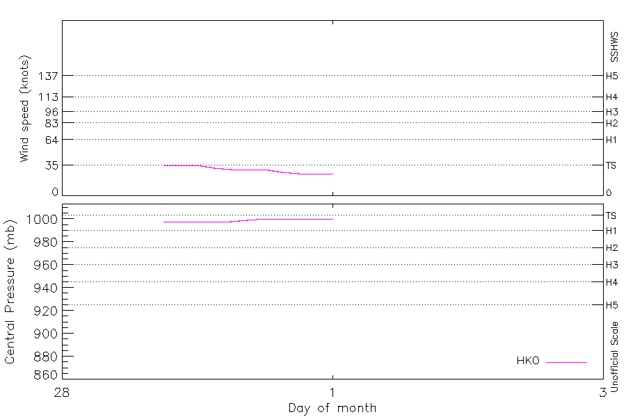
Intensity plots
|
Radial wind information
No radial wind information for this storm
|
Position and Intensity Table
| BASIN |
ISO_TIME_________ |
NATURE |
LAT |
LON |
HKO WIND |
HKO PRES |
| |
|
|
degrees north |
degrees east |
kts |
mb |
| WP |
1976-02-28 18:00:00 |
NR |
10.30 |
147.80 |
35 |
998 |
| WP |
21:00:00 |
NR |
10.31 |
147.64 |
35 |
998 |
| WP |
1976-02-29 00:00:00 |
NR |
10.30 |
147.50 |
35 |
998 |
| WP |
03:00:00 |
NR |
10.31 |
147.32 |
32 |
998 |
| WP |
06:00:00 |
NR |
10.30 |
147.10 |
30 |
998 |
| WP |
09:00:00 |
NR |
10.28 |
146.81 |
30 |
999 |
| WP |
12:00:00 |
NR |
10.20 |
146.50 |
30 |
1000 |
| WP |
15:00:00 |
NR |
10.00 |
146.23 |
27 |
1000 |
| WP |
18:00:00 |
NR |
9.80 |
146.00 |
25 |
1000 |
| WP |
21:00:00 |
NR |
9.71 |
145.79 |
25 |
1000 |
| WP |
1976-03-01 00:00:00 |
NR |
9.70 |
145.60 |
25 |
1000 |
Source Information
| Agency |
Information |
| USA |
|
| TOKYO |
|
| CMA |
|
| HKO |
tc-besttrack-data-current.txt:Line=10679:LORNA |
| NEWDELHI |
|
| REUNION |
|
| BOM |
|
| NADI |
|
| WELLINGTON |
|
| DS824 |
|
| TD9636 |
|
| TD9635 |
|
| NEUMANN |
|
| MLC |
|
All available IBTrACS Data
| SEASON |
BASIN |
SUBBASIN |
ISO_TIME_________ |
NATURE |
LAT |
LON |
DIST2LAND |
LANDFALL |
IFLAG |
USA SSHS |
HKO LAT |
HKO LON |
HKO CAT |
HKO WIND |
HKO PRES |
STORM SPEED |
STORM DIR |
| Year |
|
|
|
|
degrees north |
degrees east |
km |
km |
|
1 |
degrees north |
degrees east |
|
kts |
mb |
kts |
degrees |
| 1976 |
WP |
MM |
1976-02-28 18:00:00 |
NR |
10.30 |
147.80 |
1390 |
1389 |
___O__________ |
-5 |
10.30 |
147.80 |
TS |
35 |
998 |
3 |
273 |
| 1976 |
WP |
MM |
21:00:00 |
NR |
10.31 |
147.64 |
1389 |
1389 |
___P__________ |
-5 |
10.30 |
147.65 |
TS |
35 |
998 |
3 |
270 |
| 1976 |
WP |
MM |
1976-02-29 00:00:00 |
NR |
10.30 |
147.50 |
1389 |
1389 |
___O__________ |
-5 |
10.30 |
147.50 |
TS |
35 |
998 |
3 |
270 |
| 1976 |
WP |
MM |
03:00:00 |
NR |
10.31 |
147.32 |
1389 |
1389 |
___P__________ |
-5 |
10.31 |
147.32 |
TS |
32 |
998 |
4 |
270 |
| 1976 |
WP |
MM |
06:00:00 |
NR |
10.30 |
147.10 |
1389 |
1389 |
___O__________ |
-5 |
10.30 |
147.10 |
TD |
30 |
998 |
5 |
267 |
| 1976 |
WP |
MM |
09:00:00 |
NR |
10.28 |
146.81 |
1389 |
1378 |
___P__________ |
-5 |
10.28 |
146.81 |
TD |
30 |
999 |
6 |
260 |
| 1976 |
WP |
MM |
12:00:00 |
NR |
10.20 |
146.50 |
1378 |
1356 |
___O__________ |
-5 |
10.20 |
146.50 |
TD |
30 |
1000 |
6 |
244 |
| 1976 |
WP |
MM |
15:00:00 |
NR |
10.00 |
146.23 |
1356 |
1334 |
___P__________ |
-5 |
10.00 |
146.23 |
TD |
27 |
1000 |
6 |
231 |
| 1976 |
WP |
MM |
18:00:00 |
NR |
9.80 |
146.00 |
1335 |
1324 |
___O__________ |
-5 |
9.80 |
146.00 |
TD |
25 |
1000 |
5 |
237 |
| 1976 |
WP |
MM |
21:00:00 |
NR |
9.71 |
145.79 |
1325 |
1325 |
___P__________ |
-5 |
9.71 |
145.79 |
TD |
25 |
1000 |
4 |
256 |
| 1976 |
WP |
MM |
1976-03-01 00:00:00 |
NR |
9.70 |
145.60 |
1326 |
|
___O__________ |
-5 |
9.70 |
145.60 |
TD |
25 |
1000 |
4 |
266 |