1963
Tropical Low NOT_NAMED (1963026S19149)
IBTrACS version v04r00. Visit
IBTrACS website for data access.
Please direct all questions to the
IBTrACS Q and A forum
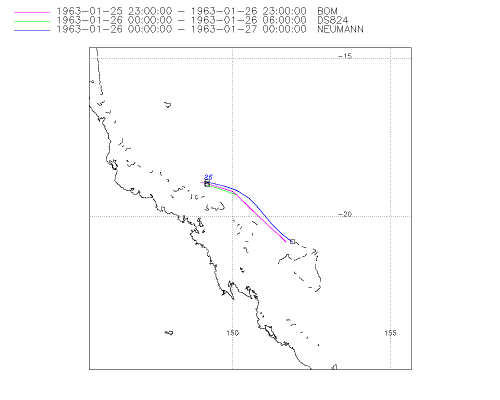
Storm track
-
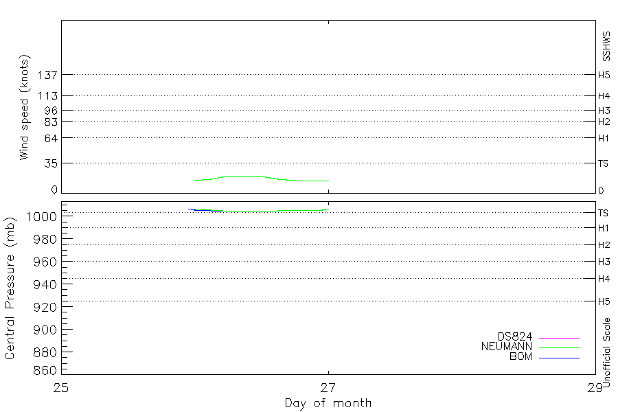
Intensity
-
Wind Radii
-
Intensity Data
-
Source Data
-
All data
Summary Information
|
|
| Storm ID |
1963026S19149 |
| Start |
Jan 25 23Z |
| Max Intensity |
20 kt (Jan 26 06Z) |
| End |
Jan 27 00Z |
| ATCF IDs |
|
| Track status |
Best track data. |
|
Storm track plot
|
Intensity plots
|
Radial wind information
No radial wind information for this storm
|
Position and Intensity Table
| BASIN |
ISO_TIME_________ |
NATURE |
LAT |
LON |
WMO PRES |
BOM PRES |
DS824 WIND |
DS824 PRES |
NEUMANN WIND |
NEUMANN PRES |
| |
|
|
degrees north |
degrees east |
mb |
mb |
kts |
mb |
kts |
mb |
| SP |
1963-01-25 23:00:00 |
NR |
-18.90 |
149.00 |
1007 |
1007 |
|
|
|
|
| SP |
1963-01-26 00:00:00 |
TS |
-18.95 |
149.18 |
|
1006 |
15 |
1007 |
15 |
1007 |
| SP |
03:00:00 |
TS |
-19.10 |
149.68 |
|
1005 |
17 |
1006 |
17 |
1006 |
| SP |
05:00:00 |
TS |
-19.19 |
150.01 |
1005 |
1005 |
19 |
1005 |
19 |
1005 |
| SP |
06:00:00 |
TS |
-19.25 |
150.14 |
|
|
20 |
1005 |
20 |
1005 |
| SP |
09:00:00 |
TS |
-19.49 |
150.46 |
|
|
|
|
20 |
1005 |
| SP |
12:00:00 |
TS |
-19.76 |
150.73 |
|
|
|
|
20 |
1005 |
| SP |
15:00:00 |
TS |
-20.05 |
151.00 |
|
|
|
|
17 |
1005 |
| SP |
18:00:00 |
TS |
-20.32 |
151.27 |
|
|
|
|
15 |
1006 |
| SP |
21:00:00 |
TS |
-20.59 |
151.56 |
|
|
|
|
15 |
1006 |
| SP |
23:00:00 |
TS |
-20.75 |
151.76 |
1007 |
1007 |
|
|
15 |
1006 |
| SP |
1963-01-27 00:00:00 |
TS |
-20.80 |
151.90 |
|
|
|
|
15 |
1007 |
Source Information
| Agency |
Information |
| USA |
|
| TOKYO |
|
| CMA |
|
| HKO |
|
| NEWDELHI |
|
| REUNION |
|
| BOM |
IDCKMSTM0S.csv:Line=3570:unnamed |
| NADI |
|
| WELLINGTON |
|
| DS824 |
aus_area.dat:328:NOT NAMED |
| TD9636 |
|
| TD9635 |
|
| NEUMANN |
tracks.sh:Storm=61:HSK1563:BSH2363:BM316 |
| MLC |
|
All available IBTrACS Data
| SEASON |
BASIN |
SUBBASIN |
ISO_TIME_________ |
NATURE |
LAT |
LON |
WMO PRES |
WMO AGENCY |
DIST2LAND |
LANDFALL |
IFLAG |
USA SSHS |
BOM LAT |
BOM LON |
BOM PRES |
BOM PRES_METHOD |
DS824 LAT |
DS824 LON |
DS824 STAGE |
DS824 WIND |
DS824 PRES |
NEUMANN LAT |
NEUMANN LON |
NEUMANN CLASS |
NEUMANN WIND |
NEUMANN PRES |
STORM SPEED |
STORM DIR |
| Year |
|
|
|
|
degrees north |
degrees east |
mb |
|
km |
km |
|
1 |
degrees north |
degrees east |
mb |
|
degrees north |
degrees east |
|
kts |
mb |
degrees north |
degrees east |
|
kts |
mb |
kts |
degrees |
| 1963 |
SP |
EA |
1963-01-25 23:00:00 |
NR |
-18.90 |
149.00 |
1007 |
bom |
143 |
143 |
______O_______ |
-5 |
-18.90 |
149.00 |
1007 |
|
|
|
|
|
|
|
|
|
|
|
11 |
106 |
| 1963 |
SP |
EA |
1963-01-26 00:00:00 |
TS |
-18.95 |
149.18 |
|
|
146 |
146 |
______P__O__O_ |
-5 |
-18.95 |
149.17 |
1006 |
|
-19.00 |
149.20 |
TC |
15 |
1007 |
-18.90 |
149.20 |
TC |
15 |
1007 |
10 |
107 |
| 1963 |
SP |
EA |
03:00:00 |
TS |
-19.10 |
149.68 |
|
|
163 |
163 |
______P__P__P_ |
-5 |
-19.10 |
149.67 |
1005 |
|
-19.15 |
149.65 |
TC |
17 |
1006 |
-19.03 |
149.74 |
TC |
17 |
1006 |
10 |
107 |
| 1963 |
SP |
EA |
05:00:00 |
TS |
-19.19 |
150.01 |
1005 |
bom |
175 |
175 |
______O__P__P_ |
-5 |
-19.20 |
150.00 |
1005 |
4 |
-19.25 |
149.95 |
TC |
19 |
1005 |
-19.14 |
150.06 |
TC |
19 |
1005 |
9 |
110 |
| 1963 |
SP |
EA |
06:00:00 |
TS |
-19.25 |
150.14 |
|
|
176 |
176 |
______P__O__O_ |
-5 |
-19.29 |
150.09 |
|
|
-19.30 |
150.10 |
TC |
20 |
1005 |
-19.20 |
150.20 |
TC |
20 |
1005 |
8 |
126 |
| 1963 |
SP |
EA |
09:00:00 |
TS |
-19.49 |
150.46 |
|
|
198 |
194 |
______P_____P_ |
-5 |
-19.56 |
150.37 |
|
|
|
|
TC |
|
|
-19.43 |
150.54 |
TC |
20 |
1005 |
8 |
133 |
| 1963 |
SP |
EA |
12:00:00 |
TS |
-19.76 |
150.73 |
|
|
203 |
203 |
______P_____O_ |
-5 |
-19.82 |
150.66 |
|
|
|
|
|
|
|
-19.70 |
150.80 |
TC |
20 |
1005 |
8 |
137 |
| 1963 |
SP |
EA |
15:00:00 |
TS |
-20.05 |
151.00 |
|
|
224 |
218 |
______P_____P_ |
-5 |
-20.09 |
150.94 |
|
|
|
|
|
|
|
-20.00 |
151.05 |
TC |
17 |
1005 |
8 |
138 |
| 1963 |
SP |
EA |
18:00:00 |
TS |
-20.32 |
151.27 |
|
|
236 |
217 |
______P_____O_ |
-5 |
-20.36 |
151.22 |
|
|
|
|
|
|
|
-20.30 |
151.30 |
TC |
15 |
1006 |
8 |
136 |
| 1963 |
SP |
EA |
21:00:00 |
TS |
-20.59 |
151.56 |
|
|
221 |
211 |
______P_____P_ |
-5 |
-20.62 |
151.51 |
|
|
|
|
|
|
|
-20.56 |
151.59 |
TC |
15 |
1006 |
8 |
132 |
| 1963 |
SP |
EA |
23:00:00 |
TS |
-20.75 |
151.76 |
1007 |
bom |
221 |
211 |
______O_____P_ |
-5 |
-20.80 |
151.70 |
1007 |
|
|
|
|
|
|
-20.72 |
151.79 |
TC |
15 |
1006 |
8 |
124 |
| 1963 |
SP |
EA |
1963-01-27 00:00:00 |
TS |
-20.80 |
151.90 |
|
|
217 |
|
____________O_ |
-5 |
|
|
|
|
|
|
|
|
|
-20.80 |
151.90 |
TC |
15 |
1007 |
8 |
112 |