1961
Tropical Depression NOT_NAMED (1961285N25165)
IBTrACS version v04r00. Visit
IBTrACS website for data access.
Please direct all questions to the
IBTrACS Q and A forum
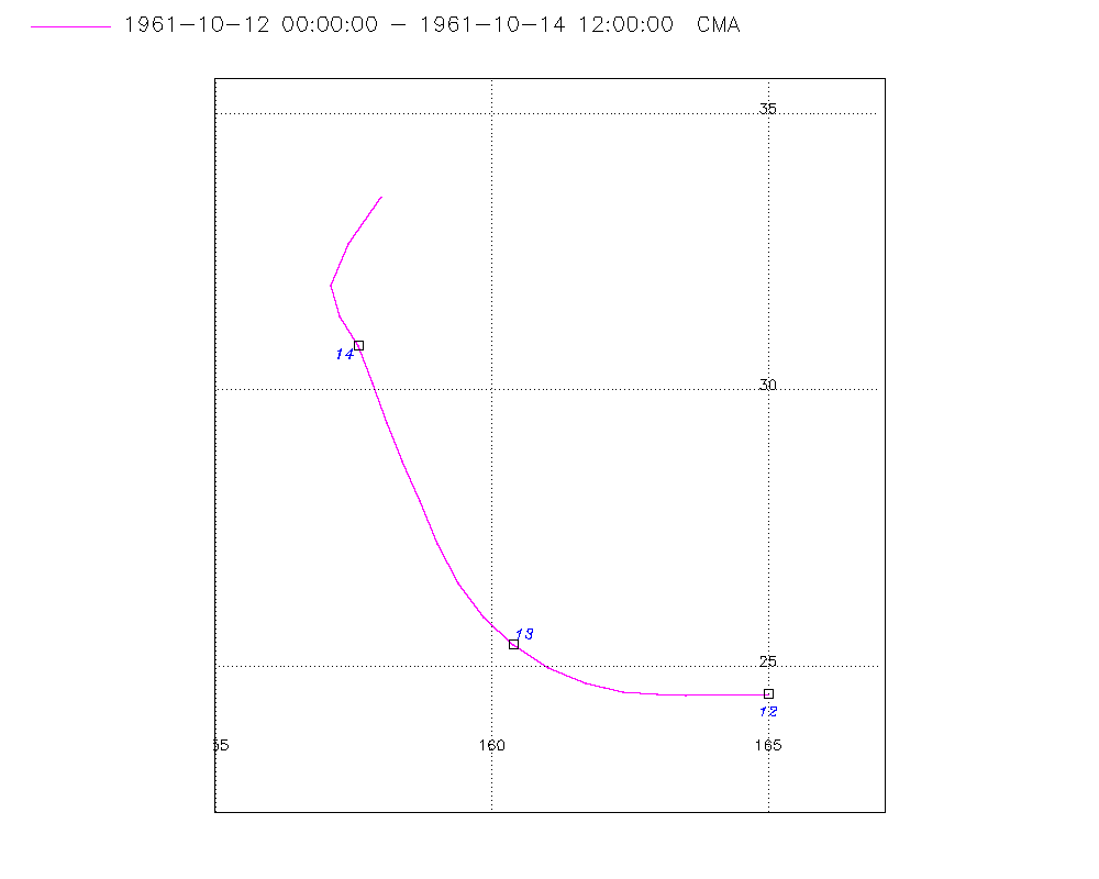
Storm track
-
Intensity
-
Wind Radii
-
Intensity Data
-
Source Data
-
All data
Summary Information
|
|
| Storm ID |
1961285N25165 |
| Start |
Oct 12 00Z |
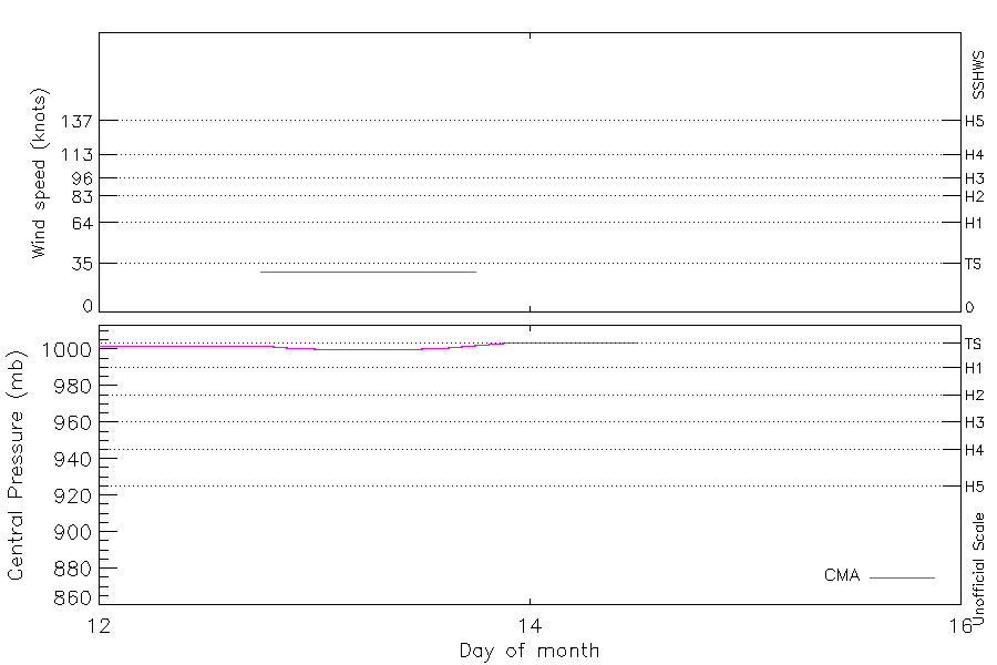
| Max Intensity |
29 kt (Oct 12 18Z) |
| End |
Oct 14 12Z |
| ATCF IDs |
|
| Track status |
Best track data. |
|
Storm track plot
|
Intensity plots
|
Radial wind information
No radial wind information for this storm
|
Position and Intensity Table
| BASIN |
ISO_TIME_________ |
NATURE |
LAT |
LON |
CMA WIND |
CMA PRES |
| |
|
|
degrees north |
degrees east |
kts |
mb |
| WP |
1961-10-12 00:00:00 |
TS |
24.50 |
165.00 |
|
1002 |
| WP |
03:00:00 |
TS |
24.51 |
164.49 |
|
1002 |
| WP |
06:00:00 |
TS |
24.50 |
164.00 |
|
1002 |
| WP |
09:00:00 |
TS |
24.48 |
163.52 |
|
1002 |
| WP |
12:00:00 |
TS |
24.50 |
163.00 |
|
1002 |
| WP |
15:00:00 |
TS |
24.55 |
162.37 |
|
1002 |
| WP |
18:00:00 |
TS |
24.70 |
161.70 |
29 |
1002 |
| WP |
21:00:00 |
TS |
24.98 |
161.03 |
29 |
1001 |
| WP |
1961-10-13 00:00:00 |
TS |
25.40 |
160.40 |
29 |
1000 |
| WP |
03:00:00 |
TS |
25.89 |
159.85 |
29 |
1000 |
| WP |
06:00:00 |
TS |
26.50 |
159.40 |
29 |
1000 |
| WP |
09:00:00 |
TS |
27.23 |
159.02 |
29 |
1000 |
| WP |
12:00:00 |
TS |
28.00 |
158.70 |
29 |
1000 |
| WP |
15:00:00 |
TS |
28.71 |
158.38 |
29 |
1001 |
| WP |
18:00:00 |
TS |
29.40 |
158.10 |
29 |
1002 |
| WP |
21:00:00 |
TS |
30.12 |
157.84 |
|
1003 |
| WP |
1961-10-14 00:00:00 |
TS |
30.80 |
157.60 |
|
1004 |
| WP |
03:00:00 |
TS |
31.33 |
157.25 |
|
1004 |
| WP |
06:00:00 |
ET |
31.90 |
157.10 |
|
1004 |
| WP |
09:00:00 |
ET |
32.64 |
157.41 |
|
1004 |
| WP |
12:00:00 |
ET |
33.50 |
158.00 |
|
1004 |
Source Information
| Agency |
Information |
| USA |
|
| TOKYO |
|
| CMA |
CH1961BST.txt:Storm=37:(nameless) |
| HKO |
|
| NEWDELHI |
|
| REUNION |
|
| BOM |
|
| NADI |
|
| WELLINGTON |
|
| DS824 |
|
| TD9636 |
|
| TD9635 |
|
| NEUMANN |
|
| MLC |
|
All available IBTrACS Data
| SEASON |
BASIN |
SUBBASIN |
ISO_TIME_________ |
NATURE |
LAT |
LON |
DIST2LAND |
LANDFALL |
IFLAG |
USA SSHS |
CMA LAT |
CMA LON |
CMA CAT |
CMA WIND |
CMA PRES |
STORM SPEED |
STORM DIR |
| Year |
|
|
|
|
degrees north |
degrees east |
km |
km |
|
1 |
degrees north |
degrees east |
1 |
kts |
mb |
kts |
degrees |
| 1961 |
WP |
MM |
1961-10-12 00:00:00 |
TS |
24.50 |
165.00 |
2620 |
2578 |
__O___________ |
-5 |
24.50 |
165.00 |
0 |
|
1002 |
9 |
271 |
| 1961 |
WP |
MM |
03:00:00 |
TS |
24.51 |
164.49 |
2578 |
2537 |
__P___________ |
-5 |
24.51 |
164.49 |
0 |
|
1002 |
9 |
270 |
| 1961 |
WP |
MM |
06:00:00 |
TS |
24.50 |
164.00 |
2537 |
2495 |
__O___________ |
-5 |
24.50 |
164.00 |
0 |
|
1002 |
9 |
269 |
| 1961 |
WP |
MM |
09:00:00 |
TS |
24.48 |
163.52 |
2495 |
2454 |
__P___________ |
-5 |
24.48 |
163.52 |
0 |
|
1002 |
9 |
270 |
| 1961 |
WP |
MM |
12:00:00 |
TS |
24.50 |
163.00 |
2454 |
2405 |
__O___________ |
-5 |
24.50 |
163.00 |
0 |
|
1002 |
10 |
273 |
| 1961 |
WP |
MM |
15:00:00 |
TS |
24.55 |
162.37 |
2405 |
2335 |
__P___________ |
-5 |
24.55 |
162.37 |
0 |
|
1002 |
12 |
280 |
| 1961 |
WP |
MM |
18:00:00 |
TS |
24.70 |
161.70 |
2335 |
2266 |
__O___________ |
-5 |
24.70 |
161.70 |
1 |
29 |
1002 |
13 |
290 |
| 1961 |
WP |
MM |
21:00:00 |
TS |
24.98 |
161.03 |
2258 |
2183 |
__P___________ |
-5 |
24.98 |
161.03 |
1 |
29 |
1001 |
14 |
301 |
| 1961 |
WP |
MM |
1961-10-13 00:00:00 |
TS |
25.40 |
160.40 |
2183 |
2110 |
__O___________ |
-5 |
25.40 |
160.40 |
1 |
29 |
1000 |
14 |
311 |
| 1961 |
WP |
MM |
03:00:00 |
TS |
25.89 |
159.85 |
2110 |
2030 |
__P___________ |
-5 |
25.89 |
159.85 |
1 |
29 |
1000 |
14 |
321 |
| 1961 |
WP |
MM |
06:00:00 |
TS |
26.50 |
159.40 |
2030 |
1954 |
__O___________ |
-5 |
26.50 |
159.40 |
1 |
29 |
1000 |
15 |
331 |
| 1961 |
WP |
MM |
09:00:00 |
TS |
27.23 |
159.02 |
1954 |
1881 |
__P___________ |
-5 |
27.23 |
159.02 |
1 |
29 |
1000 |
16 |
337 |
| 1961 |
WP |
MM |
12:00:00 |
TS |
28.00 |
158.70 |
1881 |
1816 |
__O___________ |
-5 |
28.00 |
158.70 |
1 |
29 |
1000 |
16 |
339 |
| 1961 |
WP |
MM |
15:00:00 |
TS |
28.71 |
158.38 |
1816 |
1752 |
__P___________ |
-5 |
28.71 |
158.38 |
1 |
29 |
1001 |
15 |
339 |
| 1961 |
WP |
MM |
18:00:00 |
TS |
29.40 |
158.10 |
1752 |
1699 |
__O___________ |
-5 |
29.40 |
158.10 |
1 |
29 |
1002 |
15 |
342 |
| 1961 |
WP |
MM |
21:00:00 |
TS |
30.12 |
157.84 |
1691 |
1640 |
__P___________ |
-5 |
30.12 |
157.84 |
1 |
|
1003 |
15 |
343 |
| 1961 |
WP |
MM |
1961-10-14 00:00:00 |
TS |
30.80 |
157.60 |
1640 |
1592 |
__O___________ |
-5 |
30.80 |
157.60 |
0 |
|
1004 |
13 |
337 |
| 1961 |
WP |
MM |
03:00:00 |
TS |
31.33 |
157.25 |
1583 |
1550 |
__P___________ |
-5 |
31.33 |
157.25 |
0 |
|
1004 |
12 |
339 |
| 1961 |
WP |
MM |
06:00:00 |
ET |
31.90 |
157.10 |
1550 |
1543 |
__O___________ |
-5 |
31.90 |
157.10 |
9 |
|
1004 |
13 |
6 |
| 1961 |
WP |
MM |
09:00:00 |
ET |
32.64 |
157.41 |
1552 |
1520 |
__P___________ |
-5 |
32.64 |
157.41 |
9 |
|
1004 |
18 |
25 |
| 1961 |
WP |
MM |
12:00:00 |
ET |
33.50 |
158.00 |
1520 |
|
__O___________ |
-5 |
33.50 |
158.00 |
9 |
|
1004 |
20 |
30 |