1950
Tropical Depression NOT_NAMED (1950299N12145)
IBTrACS version v04r00. Visit
IBTrACS website for data access.
Please direct all questions to the
IBTrACS Q and A forum
Storm track
-
Intensity
-
Wind Radii
-
Intensity Data
-
Source Data
-
All data
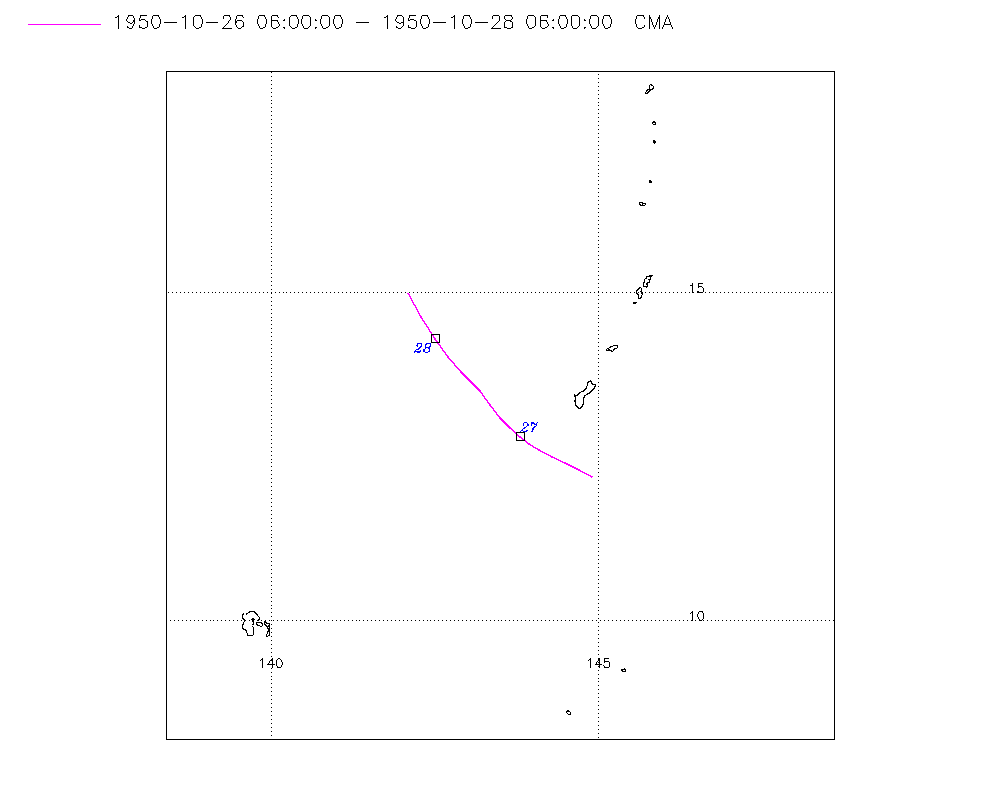
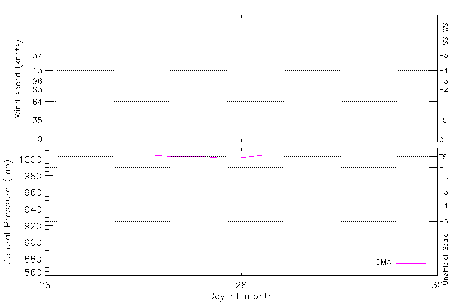
Summary Information
|
|
| Storm ID |
1950299N12145 |
| Start |
Oct 26 06Z |
| Max Intensity |
29 kt (Oct 27 12Z) |
| End |
Oct 28 06Z |
| ATCF IDs |
|
| Track status |
Best track data. |
|
Storm track plot
|
Intensity plots
|
Radial wind information
No radial wind information for this storm
|
Position and Intensity Table
| BASIN |
ISO_TIME_________ |
NATURE |
LAT |
LON |
CMA WIND |
CMA PRES |
| |
|
|
degrees north |
degrees east |
kts |
mb |
| WP |
1950-10-26 06:00:00 |
TS |
12.20 |
144.90 |
|
1006 |
| WP |
09:00:00 |
TS |
12.30 |
144.70 |
|
1006 |
| WP |
12:00:00 |
TS |
12.40 |
144.50 |
|
1006 |
| WP |
15:00:00 |
TS |
12.50 |
144.29 |
|
1006 |
| WP |
18:00:00 |
TS |
12.60 |
144.10 |
|
1006 |
| WP |
21:00:00 |
TS |
12.69 |
143.94 |
|
1006 |
| WP |
1950-10-27 00:00:00 |
TS |
12.80 |
143.80 |
|
1006 |
| WP |
03:00:00 |
TS |
12.93 |
143.65 |
|
1005 |
| WP |
06:00:00 |
TS |
13.10 |
143.50 |
|
1004 |
| WP |
09:00:00 |
TS |
13.30 |
143.35 |
|
1004 |
| WP |
12:00:00 |
TS |
13.50 |
143.20 |
29 |
1004 |
| WP |
15:00:00 |
TS |
13.64 |
143.06 |
29 |
1003 |
| WP |
18:00:00 |
TS |
13.80 |
142.90 |
29 |
1002 |
| WP |
21:00:00 |
TS |
14.02 |
142.71 |
29 |
1002 |
| WP |
1950-10-28 00:00:00 |
TS |
14.30 |
142.50 |
29 |
1002 |
| WP |
03:00:00 |
TS |
14.64 |
142.30 |
|
1004 |
| WP |
06:00:00 |
TS |
15.00 |
142.10 |
|
1006 |
Source Information
| Agency |
Information |
| USA |
|
| TOKYO |
|
| CMA |
CH1950BST.txt:Storm=36:(nameless) |
| HKO |
|
| NEWDELHI |
|
| REUNION |
|
| BOM |
|
| NADI |
|
| WELLINGTON |
|
| DS824 |
|
| TD9636 |
|
| TD9635 |
|
| NEUMANN |
|
| MLC |
|
All available IBTrACS Data
| SEASON |
BASIN |
SUBBASIN |
ISO_TIME_________ |
NATURE |
LAT |
LON |
DIST2LAND |
LANDFALL |
IFLAG |
USA SSHS |
CMA LAT |
CMA LON |
CMA CAT |
CMA WIND |
CMA PRES |
STORM SPEED |
STORM DIR |
| Year |
|
|
|
|
degrees north |
degrees east |
km |
km |
|
1 |
degrees north |
degrees east |
1 |
kts |
mb |
kts |
degrees |
| 1950 |
WP |
MM |
1950-10-26 06:00:00 |
TS |
12.20 |
144.90 |
1613 |
1613 |
__O___________ |
-5 |
12.20 |
144.90 |
0 |
|
1006 |
4 |
297 |
| 1950 |
WP |
MM |
09:00:00 |
TS |
12.30 |
144.70 |
1627 |
1627 |
__P___________ |
-5 |
12.30 |
144.70 |
0 |
|
1006 |
4 |
297 |
| 1950 |
WP |
MM |
12:00:00 |
TS |
12.40 |
144.50 |
1641 |
1641 |
__O___________ |
-5 |
12.40 |
144.50 |
0 |
|
1006 |
4 |
297 |
| 1950 |
WP |
MM |
15:00:00 |
TS |
12.50 |
144.29 |
1655 |
1655 |
__P___________ |
-5 |
12.50 |
144.29 |
0 |
|
1006 |
4 |
297 |
| 1950 |
WP |
MM |
18:00:00 |
TS |
12.60 |
144.10 |
1670 |
1670 |
__O___________ |
-5 |
12.60 |
144.10 |
0 |
|
1006 |
4 |
299 |
| 1950 |
WP |
MM |
21:00:00 |
TS |
12.69 |
143.94 |
1684 |
1684 |
__P___________ |
-5 |
12.69 |
143.94 |
0 |
|
1006 |
4 |
304 |
| 1950 |
WP |
MM |
1950-10-27 00:00:00 |
TS |
12.80 |
143.80 |
1697 |
1697 |
__O___________ |
-5 |
12.80 |
143.80 |
0 |
|
1006 |
4 |
310 |
| 1950 |
WP |
MM |
03:00:00 |
TS |
12.93 |
143.65 |
1710 |
1712 |
__P___________ |
-5 |
12.93 |
143.65 |
0 |
|
1005 |
4 |
316 |
| 1950 |
WP |
MM |
06:00:00 |
TS |
13.10 |
143.50 |
1737 |
1737 |
__O___________ |
-5 |
13.10 |
143.50 |
0 |
|
1004 |
5 |
321 |
| 1950 |
WP |
MM |
09:00:00 |
TS |
13.30 |
143.35 |
1761 |
1761 |
__P___________ |
-5 |
13.30 |
143.35 |
0 |
|
1004 |
5 |
324 |
| 1950 |
WP |
MM |
12:00:00 |
TS |
13.50 |
143.20 |
1779 |
1779 |
__O___________ |
-5 |
13.50 |
143.20 |
1 |
29 |
1004 |
4 |
320 |
| 1950 |
WP |
MM |
15:00:00 |
TS |
13.64 |
143.06 |
1786 |
1786 |
__P___________ |
-5 |
13.64 |
143.06 |
1 |
29 |
1003 |
4 |
316 |
| 1950 |
WP |
MM |
18:00:00 |
TS |
13.80 |
142.90 |
1801 |
1801 |
__O___________ |
-5 |
13.80 |
142.90 |
1 |
29 |
1002 |
5 |
318 |
| 1950 |
WP |
MM |
21:00:00 |
TS |
14.02 |
142.71 |
1816 |
1816 |
__P___________ |
-5 |
14.02 |
142.71 |
1 |
29 |
1002 |
6 |
322 |
| 1950 |
WP |
MM |
1950-10-28 00:00:00 |
TS |
14.30 |
142.50 |
1841 |
1834 |
__O___________ |
-5 |
14.30 |
142.50 |
1 |
29 |
1002 |
7 |
327 |
| 1950 |
WP |
MM |
03:00:00 |
TS |
14.64 |
142.30 |
1834 |
1819 |
__P___________ |
-5 |
14.64 |
142.30 |
1 |
|
1004 |
8 |
331 |
| 1950 |
WP |
MM |
06:00:00 |
TS |
15.00 |
142.10 |
1821 |
|
__O___________ |
-5 |
15.00 |
142.10 |
0 |
|
1006 |
8 |
333 |