1945
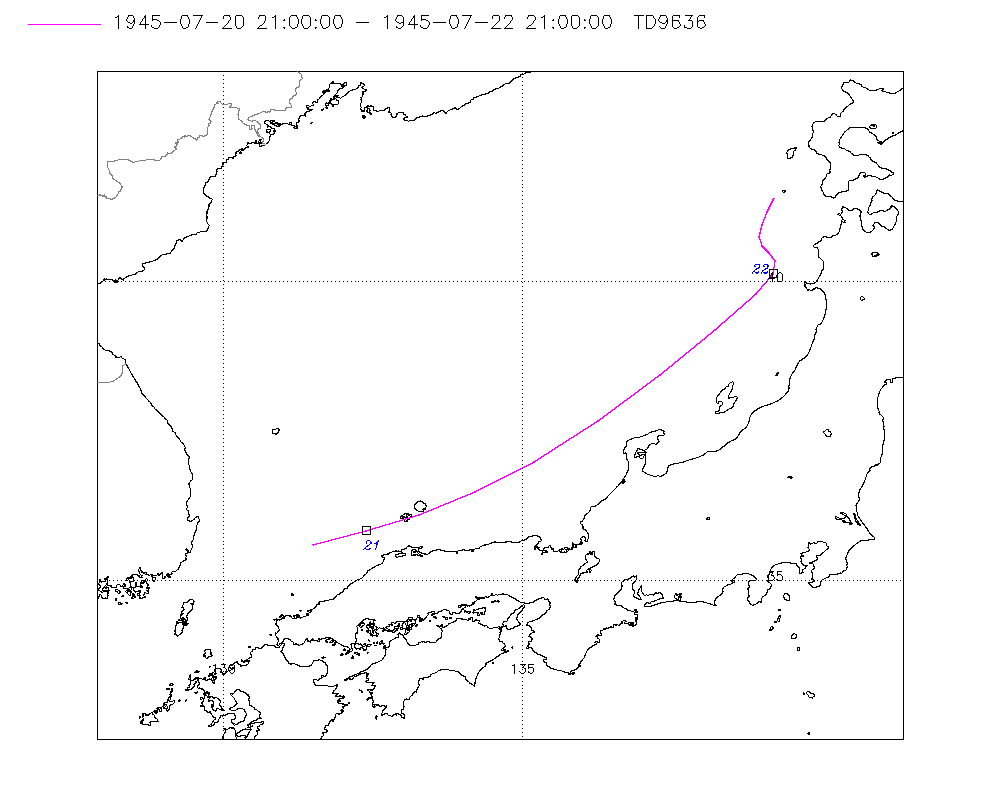
NOT_NAMED (1945202N34130)
IBTrACS version v04r00. Visit
IBTrACS website for data access.
Please direct all questions to the
IBTrACS Q and A forum
Storm track
-
Intensity
-
Wind Radii
-
Intensity Data
-
Source Data
-
All data
Summary Information
|
|
| Storm ID |
1945202N34130 |
| Start |
Jul 20 15Z |
| End |
Jul 22 21Z |
| ATCF IDs |
|
| Track status |
Best track data. |
|
Storm track plot
|
Intensity plots
No Intensity information for this storm
|
Radial wind information
No radial wind information for this storm
|
Position and Intensity Table
| BASIN |
ISO_TIME_________ |
NATURE |
LAT |
LON |
| |
|
|
degrees north |
degrees east |
| WP |
1945-07-20 15:00:00 |
NR |
34.46 |
130.02 |
| WP |
18:00:00 |
NR |
35.07 |
130.71 |
| WP |
21:00:00 |
NR |
35.60 |
131.50 |
| WP |
1945-07-21 00:00:00 |
NR |
35.98 |
132.35 |
| WP |
03:00:00 |
NR |
36.29 |
133.27 |
| WP |
06:00:00 |
NR |
36.60 |
134.24 |
| WP |
09:00:00 |
NR |
37.00 |
135.20 |
| WP |
12:00:00 |
NR |
37.68 |
136.26 |
| WP |
15:00:00 |
NR |
38.45 |
137.30 |
| WP |
18:00:00 |
NR |
39.19 |
138.22 |
| WP |
21:00:00 |
NR |
39.80 |
138.90 |
| WP |
1945-07-22 00:00:00 |
NR |
40.14 |
139.19 |
| WP |
03:00:00 |
NR |
40.34 |
139.23 |
| WP |
06:00:00 |
NR |
40.48 |
139.12 |
| WP |
09:00:00 |
NR |
40.60 |
139.00 |
| WP |
12:00:00 |
NR |
40.76 |
138.96 |
| WP |
15:00:00 |
NR |
40.95 |
138.99 |
| WP |
18:00:00 |
NR |
41.17 |
139.08 |
| WP |
21:00:00 |
NR |
41.40 |
139.20 |
Source Information
| Agency |
Information |
| USA |
|
| TOKYO |
|
| CMA |
|
| HKO |
|
| NEWDELHI |
|
| REUNION |
|
| BOM |
|
| NADI |
|
| WELLINGTON |
|
| DS824 |
|
| TD9636 |
cons_worldwide_trop_cyclone_18710101-19891231-003:Line=13705 |
| TD9635 |
|
| NEUMANN |
|
| MLC |
|
All available IBTrACS Data
| SEASON |
BASIN |
SUBBASIN |
ISO_TIME_________ |
NATURE |
LAT |
LON |
DIST2LAND |
LANDFALL |
IFLAG |
USA SSHS |
TD9636 LAT |
TD9636 LON |
TD9636 STAGE |
STORM SPEED |
STORM DIR |
| Year |
|
|
|
|
degrees north |
degrees east |
km |
km |
|
1 |
degrees north |
degrees east |
|
kts |
degrees |
| 1945 |
WP |
MM |
1945-07-20 15:00:00 |
NR |
34.46 |
130.02 |
85 |
70 |
______________ |
-5 |
|
|
|
17 |
43 |
| 1945 |
WP |
MM |
18:00:00 |
NR |
35.07 |
130.71 |
91 |
89 |
______________ |
-5 |
|
|
|
17 |
47 |
| 1945 |
WP |
MM |
21:00:00 |
NR |
35.60 |
131.50 |
92 |
66 |
__________O___ |
-5 |
35.60 |
131.50 |
7 |
16 |
56 |
| 1945 |
WP |
MM |
1945-07-21 00:00:00 |
NR |
35.98 |
132.35 |
72 |
66 |
__________P___ |
-5 |
35.83 |
132.38 |
7 |
16 |
64 |
| 1945 |
WP |
MM |
03:00:00 |
NR |
36.29 |
133.27 |
89 |
89 |
__________P___ |
-5 |
36.11 |
133.27 |
7 |
16 |
68 |
| 1945 |
WP |
MM |
06:00:00 |
NR |
36.60 |
134.24 |
112 |
111 |
__________P___ |
-5 |
36.48 |
134.21 |
7 |
17 |
65 |
| 1945 |
WP |
MM |
09:00:00 |
NR |
37.00 |
135.20 |
111 |
57 |
__________O___ |
-5 |
37.00 |
135.20 |
7 |
19 |
56 |
| 1945 |
WP |
MM |
12:00:00 |
NR |
37.68 |
136.26 |
55 |
51 |
__________P___ |
-5 |
37.68 |
136.26 |
7 |
22 |
49 |
| 1945 |
WP |
MM |
15:00:00 |
NR |
38.45 |
137.30 |
122 |
122 |
__________P___ |
-5 |
38.45 |
137.30 |
7 |
22 |
46 |
| 1945 |
WP |
MM |
18:00:00 |
NR |
39.19 |
138.22 |
130 |
68 |
__________P___ |
-5 |
39.19 |
138.22 |
7 |
18 |
43 |
| 1945 |
WP |
MM |
21:00:00 |
NR |
39.80 |
138.90 |
68 |
47 |
__________O___ |
-5 |
39.80 |
138.90 |
7 |
12 |
38 |
| 1945 |
WP |
MM |
1945-07-22 00:00:00 |
NR |
40.14 |
139.19 |
47 |
47 |
__________P___ |
-5 |
40.14 |
139.19 |
7 |
6 |
25 |
| 1945 |
WP |
MM |
03:00:00 |
NR |
40.34 |
139.23 |
61 |
59 |
__________P___ |
-5 |
40.34 |
139.23 |
7 |
3 |
350 |
| 1945 |
WP |
MM |
06:00:00 |
NR |
40.48 |
139.12 |
68 |
68 |
__________P___ |
-5 |
40.48 |
139.12 |
7 |
3 |
326 |
| 1945 |
WP |
MM |
09:00:00 |
NR |
40.60 |
139.00 |
75 |
75 |
__________O___ |
-5 |
40.60 |
139.00 |
7 |
3 |
336 |
| 1945 |
WP |
MM |
12:00:00 |
NR |
40.76 |
138.96 |
78 |
78 |
__________P___ |
-5 |
40.76 |
138.96 |
7 |
4 |
0 |
| 1945 |
WP |
MM |
15:00:00 |
NR |
40.95 |
138.99 |
87 |
78 |
__________P___ |
-5 |
40.95 |
138.99 |
7 |
4 |
14 |
| 1945 |
WP |
MM |
18:00:00 |
NR |
41.17 |
139.08 |
78 |
66 |
__________P___ |
-5 |
41.17 |
139.08 |
7 |
5 |
19 |
| 1945 |
WP |
MM |
21:00:00 |
NR |
41.40 |
139.20 |
66 |
|
__________O___ |
-5 |
41.40 |
139.20 |
7 |
5 |
21 |