1939
Tropical Low NOT_NAMED (1939011S09091)
IBTrACS version v04r00. Visit
IBTrACS website for data access.
Please direct all questions to the
IBTrACS Q and A forum
Storm track
-
Intensity
-
Wind Radii
-
Intensity Data
-
Source Data
-
All data
Summary Information
|
|
| Storm ID |
1939011S09091 |
| Start |
Jan 11 00Z |
| Max Intensity |
25 kt (Jan 11 03Z) |
| End |
Jan 13 00Z |
| ATCF IDs |
|
| Track status |
Best track data. |
|
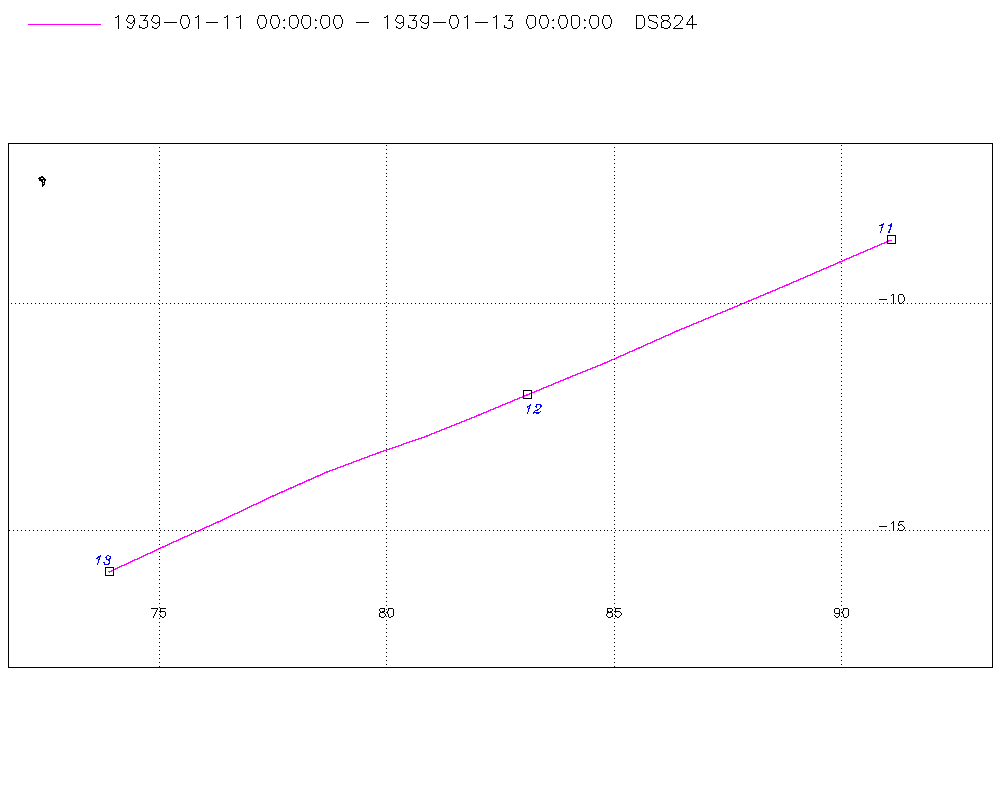
Storm track plot
|
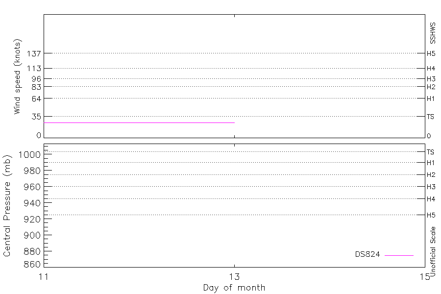
Intensity plots
|
Radial wind information
No radial wind information for this storm
|
Position and Intensity Table
| BASIN |
ISO_TIME_________ |
NATURE |
LAT |
LON |
DS824 WIND |
| |
|
|
degrees north |
degrees east |
kts |
| SI |
1939-01-11 00:00:00 |
TS |
-8.60 |
91.10 |
25 |
| SI |
03:00:00 |
TS |
-9.09 |
89.98 |
25 |
| SI |
06:00:00 |
TS |
-9.60 |
88.80 |
25 |
| SI |
09:00:00 |
TS |
-10.12 |
87.55 |
25 |
| SI |
12:00:00 |
TS |
-10.60 |
86.40 |
25 |
| SI |
15:00:00 |
TS |
-10.97 |
85.55 |
25 |
| SI |
18:00:00 |
TS |
-11.30 |
84.80 |
25 |
| SI |
21:00:00 |
TS |
-11.63 |
83.99 |
25 |
| SI |
1939-01-12 00:00:00 |
TS |
-12.00 |
83.10 |
25 |
| SI |
03:00:00 |
TS |
-12.44 |
82.04 |
25 |
| SI |
06:00:00 |
TS |
-12.90 |
80.90 |
25 |
| SI |
09:00:00 |
TS |
-13.28 |
79.81 |
25 |
| SI |
12:00:00 |
TS |
-13.70 |
78.70 |
25 |
| SI |
15:00:00 |
TS |
-14.23 |
77.51 |
25 |
| SI |
18:00:00 |
TS |
-14.80 |
76.30 |
25 |
| SI |
21:00:00 |
TS |
-15.36 |
75.10 |
25 |
| SI |
1939-01-13 00:00:00 |
TS |
-15.90 |
73.90 |
25 |
Source Information
| Agency |
Information |
| USA |
|
| TOKYO |
|
| CMA |
|
| HKO |
|
| NEWDELHI |
|
| REUNION |
|
| BOM |
|
| NADI |
|
| WELLINGTON |
|
| DS824 |
s_hem.dat:365:NOT NAMED |
| TD9636 |
|
| TD9635 |
|
| NEUMANN |
|
| MLC |
|
All available IBTrACS Data
| SEASON |
BASIN |
SUBBASIN |
ISO_TIME_________ |
NATURE |
LAT |
LON |
DIST2LAND |
LANDFALL |
IFLAG |
USA SSHS |
DS824 LAT |
DS824 LON |
DS824 STAGE |
DS824 WIND |
STORM SPEED |
STORM DIR |
| Year |
|
|
|
|
degrees north |
degrees east |
km |
km |
|
1 |
degrees north |
degrees east |
|
kts |
kts |
degrees |
| 1939 |
SI |
WA |
1939-01-11 00:00:00 |
TS |
-8.60 |
91.10 |
1159 |
1159 |
_________O____ |
-5 |
-8.60 |
91.10 |
TC |
25 |
24 |
246 |
| 1939 |
SI |
MM |
03:00:00 |
TS |
-9.09 |
89.98 |
1287 |
1287 |
_________P____ |
-5 |
-9.09 |
89.98 |
TC |
25 |
25 |
246 |
| 1939 |
SI |
MM |
06:00:00 |
TS |
-9.60 |
88.80 |
1425 |
1425 |
_________O____ |
-5 |
-9.60 |
88.80 |
TC |
25 |
26 |
247 |
| 1939 |
SI |
MM |
09:00:00 |
TS |
-10.12 |
87.55 |
1573 |
1573 |
_________P____ |
-5 |
-10.12 |
87.55 |
TC |
25 |
26 |
247 |
| 1939 |
SI |
MM |
12:00:00 |
TS |
-10.60 |
86.40 |
1704 |
1704 |
_________O____ |
-5 |
-10.60 |
86.40 |
TC |
25 |
21 |
247 |
| 1939 |
SI |
MM |
15:00:00 |
TS |
-10.97 |
85.55 |
1810 |
1810 |
_________P____ |
-5 |
-10.97 |
85.55 |
TC |
25 |
17 |
246 |
| 1939 |
SI |
MM |
18:00:00 |
TS |
-11.30 |
84.80 |
1892 |
1892 |
_________O____ |
-5 |
-11.30 |
84.80 |
TC |
25 |
17 |
246 |
| 1939 |
SI |
MM |
21:00:00 |
TS |
-11.63 |
83.99 |
1984 |
1984 |
_________P____ |
-5 |
-11.63 |
83.99 |
TC |
25 |
18 |
247 |
| 1939 |
SI |
MM |
1939-01-12 00:00:00 |
TS |
-12.00 |
83.10 |
2024 |
2023 |
_________O____ |
-5 |
-12.00 |
83.10 |
TC |
25 |
21 |
247 |
| 1939 |
SI |
MM |
03:00:00 |
TS |
-12.44 |
82.04 |
2056 |
2056 |
_________P____ |
-5 |
-12.44 |
82.04 |
TC |
25 |
23 |
247 |
| 1939 |
SI |
MM |
06:00:00 |
TS |
-12.90 |
80.90 |
2106 |
2106 |
_________O____ |
-5 |
-12.90 |
80.90 |
TC |
25 |
23 |
249 |
| 1939 |
SI |
MM |
09:00:00 |
TS |
-13.28 |
79.81 |
2152 |
2152 |
_________P____ |
-5 |
-13.28 |
79.81 |
TC |
25 |
23 |
250 |
| 1939 |
SI |
MM |
12:00:00 |
TS |
-13.70 |
78.70 |
2205 |
2205 |
_________O____ |
-5 |
-13.70 |
78.70 |
TC |
25 |
24 |
247 |
| 1939 |
SI |
MM |
15:00:00 |
TS |
-14.23 |
77.51 |
2198 |
2064 |
_________P____ |
-5 |
-14.23 |
77.51 |
TC |
25 |
26 |
245 |
| 1939 |
SI |
MM |
18:00:00 |
TS |
-14.80 |
76.30 |
2054 |
1924 |
_________O____ |
-5 |
-14.80 |
76.30 |
TC |
25 |
26 |
244 |
| 1939 |
SI |
MM |
21:00:00 |
TS |
-15.36 |
75.10 |
1910 |
1780 |
_________P____ |
-5 |
-15.36 |
75.10 |
TC |
25 |
26 |
245 |
| 1939 |
SI |
MM |
1939-01-13 00:00:00 |
TS |
-15.90 |
73.90 |
1770 |
|
_________O____ |
-5 |
-15.90 |
73.90 |
TC |
25 |
25 |
245 |