1929
Tropical Cyclone NOT_NAMED (1929009S15132)
IBTrACS version v04r00. Visit
IBTrACS website for data access.
Please direct all questions to the
IBTrACS Q and A forum
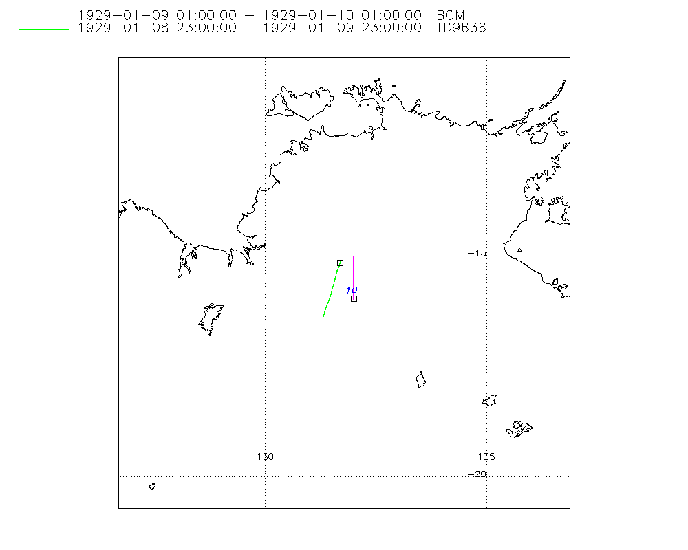
Storm track
-
Intensity
-
Wind Radii
-
Intensity Data
-
Source Data
-
All data
Summary Information
|
|
| Storm ID |
1929009S15132 |
| Start |
Jan 8 23Z |
| Max Intensity |
40 kt (Jan 10 00Z), 995 mb (Jan 10 00Z) |
| End |
Jan 10 01Z |
| ATCF IDs |
|
| Track status |
Best track data. |
|
Storm track plot
|
Intensity plots
|
Radial wind information
No radial wind information for this storm
|
Position and Intensity Table
| BASIN |
ISO_TIME_________ |
NATURE |
LAT |
LON |
WMO PRES |
BOM PRES |
DS824 WIND |
DS824 PRES |
| |
|
|
degrees north |
degrees east |
mb |
mb |
kts |
mb |
| SI |
1929-01-08 23:00:00 |
NR |
-15.10 |
131.70 |
|
|
|
|
| SI |
1929-01-09 00:00:00 |
NR |
-15.16 |
131.68 |
|
|
|
|
| SI |
01:00:00 |
NR |
-15.16 |
131.75 |
997 |
997 |
|
|
| SI |
03:00:00 |
NR |
-15.25 |
131.76 |
|
|
|
|
| SI |
06:00:00 |
NR |
-15.38 |
131.76 |
|
|
|
|
| SI |
09:00:00 |
NR |
-15.51 |
131.77 |
|
|
|
|
| SI |
11:00:00 |
NR |
-15.61 |
131.75 |
|
|
|
|
| SI |
12:00:00 |
NR |
-15.65 |
131.74 |
|
|
|
|
| SI |
15:00:00 |
NR |
-15.79 |
131.72 |
|
|
|
|
| SI |
18:00:00 |
NR |
-15.90 |
131.74 |
|
|
|
|
| SI |
21:00:00 |
NR |
-15.99 |
131.78 |
|
|
|
|
| SI |
23:00:00 |
NR |
-16.04 |
131.82 |
|
|
|
|
| SI |
1929-01-10 00:00:00 |
TS |
-15.97 |
132.00 |
|
|
40 |
995 |
| SI |
01:00:00 |
NR |
-16.00 |
132.00 |
995 |
995 |
|
|
Source Information
| Agency |
Information |
| USA |
|
| TOKYO |
|
| CMA |
|
| HKO |
|
| NEWDELHI |
|
| REUNION |
|
| BOM |
IDCKMSTM0S.csv:Line=659:unnamed |
| NADI |
|
| WELLINGTON |
|
| DS824 |
aus_area.dat:63:NOT NAMED |
| TD9636 |
cons_worldwide_trop_cyclone_18710101-19891231-006:Line=1694 |
| TD9635 |
|
| NEUMANN |
|
| MLC |
|
All available IBTrACS Data
| SEASON |
BASIN |
SUBBASIN |
ISO_TIME_________ |
NATURE |
LAT |
LON |
WMO PRES |
WMO AGENCY |
DIST2LAND |
LANDFALL |
IFLAG |
USA SSHS |
BOM LAT |
BOM LON |
BOM PRES |
DS824 LAT |
DS824 LON |
DS824 STAGE |
DS824 WIND |
DS824 PRES |
TD9636 LAT |
TD9636 LON |
TD9636 STAGE |
STORM SPEED |
STORM DIR |
| Year |
|
|
|
|
degrees north |
degrees east |
mb |
|
km |
km |
|
1 |
degrees north |
degrees east |
mb |
degrees north |
degrees east |
|
kts |
mb |
degrees north |
degrees east |
|
kts |
degrees |
| 1929 |
SI |
WA |
1929-01-08 23:00:00 |
NR |
-15.10 |
131.70 |
|
|
0 |
0 |
__________O___ |
-5 |
|
|
|
|
|
|
|
|
-15.10 |
131.70 |
7 |
4 |
0 |
| 1929 |
SI |
WA |
1929-01-09 00:00:00 |
NR |
-15.16 |
131.68 |
|
|
0 |
0 |
__________P___ |
-5 |
|
|
|
|
|
|
|
|
-15.16 |
131.68 |
7 |
2 |
156 |
| 1929 |
SI |
WA |
01:00:00 |
NR |
-15.16 |
131.75 |
997 |
bom |
0 |
0 |
______O___P___ |
-5 |
-15.00 |
132.00 |
997 |
|
|
|
|
|
-15.22 |
131.67 |
7 |
2 |
145 |
| 1929 |
SI |
WA |
03:00:00 |
NR |
-15.25 |
131.76 |
|
|
0 |
0 |
______P___P___ |
-5 |
-15.08 |
132.00 |
|
|
|
|
|
|
-15.33 |
131.63 |
7 |
3 |
0 |
| 1929 |
SI |
WA |
06:00:00 |
NR |
-15.38 |
131.76 |
|
|
0 |
0 |
______P___P___ |
-5 |
-15.21 |
132.00 |
|
|
|
|
|
|
-15.51 |
131.58 |
7 |
3 |
175 |
| 1929 |
SI |
WA |
09:00:00 |
NR |
-15.51 |
131.77 |
|
|
0 |
0 |
______P___P___ |
-5 |
-15.33 |
132.00 |
|
|
|
|
|
|
-15.68 |
131.53 |
7 |
3 |
0 |
| 1929 |
SI |
WA |
11:00:00 |
NR |
-15.61 |
131.75 |
|
|
0 |
0 |
______P___O___ |
-5 |
-15.42 |
132.00 |
|
|
|
|
|
|
-15.80 |
131.50 |
7 |
3 |
190 |
| 1929 |
SI |
WA |
12:00:00 |
NR |
-15.65 |
131.74 |
|
|
0 |
0 |
______P___P___ |
-5 |
-15.46 |
132.00 |
|
|
|
|
|
|
-15.85 |
131.48 |
7 |
3 |
189 |
| 1929 |
SI |
WA |
15:00:00 |
NR |
-15.79 |
131.72 |
|
|
0 |
0 |
______P___P___ |
-5 |
-15.58 |
132.00 |
|
|
|
|
|
|
-16.00 |
131.43 |
7 |
2 |
183 |
| 1929 |
SI |
WA |
18:00:00 |
NR |
-15.90 |
131.74 |
|
|
0 |
0 |
______P___P___ |
-5 |
-15.71 |
132.00 |
|
|
|
|
|
|
-16.15 |
131.38 |
7 |
2 |
164 |
| 1929 |
SI |
WA |
21:00:00 |
NR |
-15.99 |
131.78 |
|
|
0 |
0 |
______P___P___ |
-5 |
-15.83 |
132.00 |
|
|
|
|
|
|
-16.30 |
131.33 |
7 |
2 |
149 |
| 1929 |
SI |
WA |
23:00:00 |
NR |
-16.04 |
131.82 |
|
|
0 |
0 |
______P___O___ |
-5 |
-15.92 |
132.00 |
|
|
|
|
|
|
-16.40 |
131.30 |
7 |
4 |
86 |
| 1929 |
SI |
WA |
1929-01-10 00:00:00 |
TS |
-15.97 |
132.00 |
|
|
0 |
0 |
______P_______ |
-5 |
-15.96 |
132.00 |
|
-16.00 |
132.00 |
TC |
40 |
995 |
|
|
7 |
5 |
77 |
| 1929 |
SI |
WA |
01:00:00 |
NR |
-16.00 |
132.00 |
995 |
bom |
0 |
|
______O_______ |
-5 |
-16.00 |
132.00 |
995 |
|
|
|
|
|
|
|
7 |
2 |
0 |